Keywords: maps
- Historical Items (939)
- Tax Records (0)
- Architecture & Landscape (209)
- Online Exhibits (33)
- Site Pages (232)
- My Maine Stories (8)
- Lesson Plans (6)
Historical Items
These results include photographs, documents, letters, paintings, artifacts, and many other kinds of Maine related items from collections around the state and elsewhere.
Item 105920

Redline map of Portland and South Portland, 1935
Contributed by: Maine Historical Society Date: 1935-11-15 Location: Portland; South Portland Media: Ink on paper
Item 4325

"Brunswick in the late Province of Mayne in New England," 1719
Contributed by: Maine Historical Society Date: 1718-01-28 Location: Brunswick Media: Ink on paper
Item 105439

Plan of the village of Augusta, 1838
Contributed by: Osher Map Library and Smith Center for Cartographic Education Date: 1838 Location: Augusta Media: Lithograph
Item 11043

Waterfront and downtown Bath, 1851
Contributed by: Patten Free Library Date: 1851 Location: Bath Media: Ink on paper
Item 105443

A shopper's guide map of Portland, 1965
Contributed by: Osher Map Library and Smith Center for Cartographic Education Date: 1965 Location: Portland; South Portland; Cape Elizabeth Media: Lithograph
Item 105267

Contributed by: Osher Map Library and Smith Center for Cartographic Education Date: 1874 Location: Skowhegan Media: Lithograph
Item 4316

Plan of J. Robinson lot, Topsham, 1761
Contributed by: Maine Historical Society Date: 1761 Location: Topsham Media: Ink on paper
Item 12570

Foster's Neck, Georgetown, 1746
Contributed by: Maine Historical Society Date: 1746-11-01 Location: Georgetown Media: Ink on paper
Item 105265

Map of the northern part of New England, 1821
Contributed by: Osher Map Library and Smith Center for Cartographic Education Date: 1821 Media: Engraving
Item 105268

Contributed by: Osher Map Library and Smith Center for Cartographic Education Date: 1875 Location: Belfast Media: Lithograph
Item 10887

Map from Hay's Guide to Portland and Motoring in Maine, 1928
Contributed by: Maine Historical Society Date: 1928 Media: Ink on paper, map
Item 11826

Moses Greenleaf's map of the District of Maine, 1815
Contributed by: Maine Historical Society Date: 1815 Media: Ink on paper, map
Item 17574

Railroad map of Northern Maine, 1910
Contributed by: Maine Historical Society Date: 1910 Media: Ink on paper, map
Item 11784

Map of the Inhabited Part of Maine, Moses Greenleaf, 1829
Contributed by: Maine Historical Society Date: 1778 Media: Ink on paper, map
Item 105316

Map of the villages of Saco and Biddeford, York County, 1851
Contributed by: Osher Map Library and Smith Center for Cartographic Education Date: 1951 Location: Saco; Biddeford Media: Lithograph
Item 18722

Modern rendering of John Small's map of Falmouth, 1753
Contributed by: Maine Historical Society Date: 1753 Location: Falmouth Media: Map, ink on paper
Item 16997

Map of Fryeburg Village in 1878
Contributed by: Fryeburg Historical Society Date: circa 1878 Location: Fryeburg Media: Map
Item 105360

Contributed by: Osher Map Library and Smith Center for Cartographic Education Date: 1855 Media: Lithograph
Item 4323
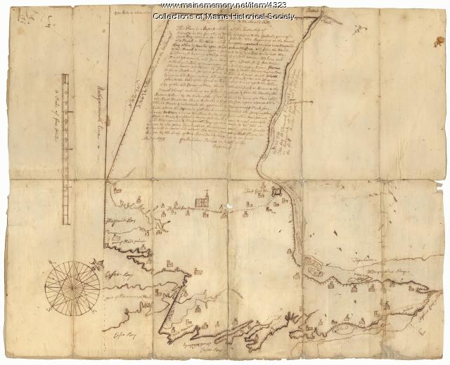
Contributed by: Maine Historical Society Date: 1738 Location: Brunswick; Harpswell; Topsham Media: Ink on paper
Item 11835

St. Croix Island and Passaquomoddy Bay, 1925
Contributed by: Maine Historical Society Date: 1925 Media: Ink on paper, map
Item 105272

"Map of Portland and some places thereabout," 1928
Contributed by: Osher Map Library and Smith Center for Cartographic Education Date: 1928 Location: Portland Media: Lithograph
Item 14760

Map of Portland Harbour and islands, 1825
Contributed by: Maine Historical Society Date: 1825 Media: Ink on paper, map
Item 110888

Map of the Northern part of the state of Maine and of the adjacent British Provinces, 1830
Contributed by: Maine Historical Society Date: circa 1830 Media: Ink on paper
Item 11827
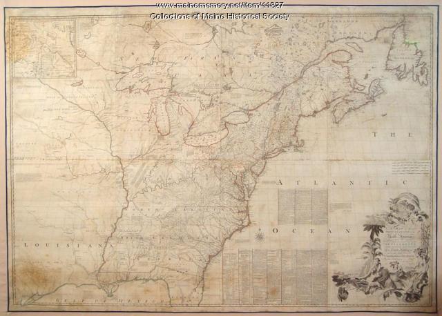
Map of the British and French North America, 1775
Contributed by: Maine Historical Society Date: 1755 Media: Ink on paper, map
