Keywords: Street maps
- Historical Items (89)
- Tax Records (0)
- Architecture & Landscape (41)
- Online Exhibits (17)
- Site Pages (62)
- My Maine Stories (2)
- Lesson Plans (0)
Historical Items
These results include photographs, documents, letters, paintings, artifacts, and many other kinds of Maine related items from collections around the state and elsewhere.
Item 71155

Contributed by: Boston Public Library Date: 1888 Location: Bridgton Media: Ink on paper, lithograph
Item 71154

Bird's-eye view of Boothbay Harbor, 1885
Contributed by: Boston Public Library Date: 1885 Location: Boothbay Harbor Media: Ink on paper, lithograph
Item 71162

Fort Fairfield bird's-eye view, 1893
Contributed by: Boston Public Library Date: 1893 Location: Fort Fairfield Media: Ink on paper, lithograph
Item 71169

Bird's-eye view of Springvale, 1888
Contributed by: Boston Public Library Date: 1888 Location: Sanford Media: Ink on paper
Item 11960

Plan of land on Bramhall Hill by Peleg Wadsworth, ca. 1800
Contributed by: City of Portland Dept. of Public Works Date: circa 1800 Location: Portland Media: Ink and wash on paper, map
Item 4173

Contributed by: Maine Historical Society Date: 1866 Location: Portland Media: Ink on paper
Item 71156

St. Stephen, New Brunswick, and Calais, 1889
Contributed by: Boston Public Library Date: 1889 Location: Calais; St. Stephen Media: Ink on paper, lithograph
Item 176

Plan of Portland, engraved as a directory, 1852
Contributed by: Maine Historical Society Date: 1852 Location: Portland Media: Ink on paper
Item 100772

Hampden, Upper and Lower corners, 1835
Contributed by: Maine Historical Society and Maine State Museum Date: circa 1835 Location: Bangor; Hampden Media: Ink and watercolor on paper
Item 11454

Contributed by: Maine Historical Society Date: 1763-08-11 Location: Brunswick; Topsham Media: Ink on paper
Item 4175

Plan of the City of Portland, 1837
Contributed by: Maine Historical Society Date: 1837 Location: Portland Media: Paper
Item 6893

A new and correct plan of Portland, 1823
Contributed by: Maine Historical Society Date: 1823 Location: Portland Media: Ink on paper
Item 28910
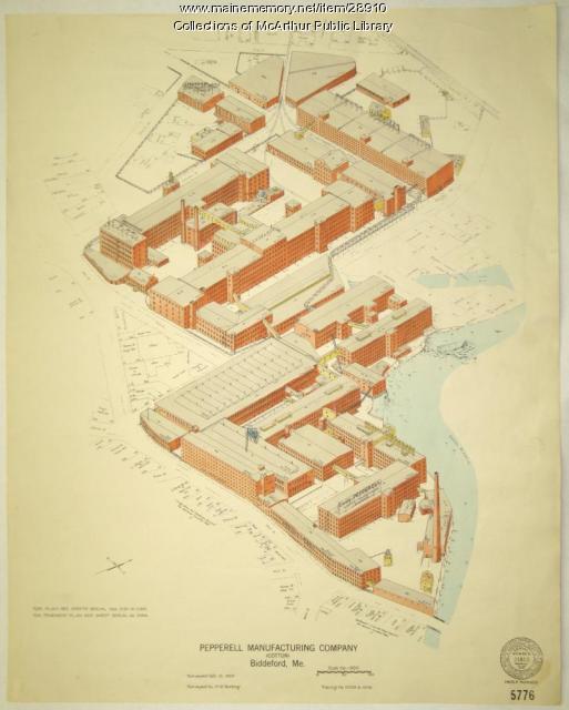
Pepperell Manufacturing fire insurance map, 1929
Contributed by: McArthur Public Library Date: 1929-10-10 Location: Biddeford Media: Ink on paper
Item 11752

Contributed by: Maine Historical Society Date: circa 1760 Location: North Yarmouth Media: Ink on paper
Item 59765
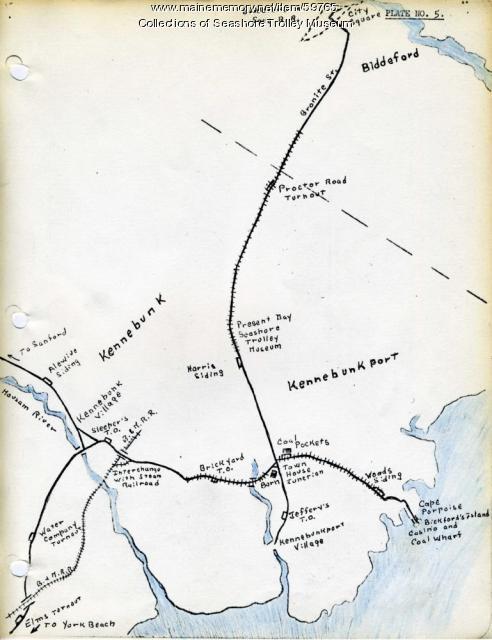
Kennebunk Village to Cape Porpoise electric railroads, ca. 1927
Contributed by: Seashore Trolley Museum Date: circa 1927 Location: Kennebunk; Cape Porpoise Media: Ink on paper
Item 35630

Plan of the Grand Trunk Railway grounds, Portland, 1858
Contributed by: Maine Historical Society Date: 1858 Location: Portland Media: Ink on paper
Item 11925

Seven lots on the Androscoggin River, 1771
Contributed by: Maine Historical Society Date: 1771 Location: Brunswick; Topsham; Freeport; Durham Media: Ink on paper
Item 59764

Kittery to York Beach electric railroad lines, ca. 1923
Contributed by: Seashore Trolley Museum Date: circa 1923 Location: York; Kittery Media: Ink on paper
Item 9948

12 Bodwell Street, Broggi Home, Sanford, ca. 1900
Contributed by: Sanford-Springvale Historical Society Date: circa 1900 Location: Sanford Media: Photographic print
Item 9949

12 Bodwell Street, Broggi Home, Sanford, ca. 1900
Contributed by: Sanford-Springvale Historical Society Date: circa 1900 Location: Sanford Media: Photographic print
Item 74738

Contributed by: Maine Historical Society Date: 1927 Media: Ink on paper
Item 59801

Freeport electric railroads map, ca. 1929
Contributed by: Seashore Trolley Museum Date: circa 1929 Location: Freeport Media: Ink on paper
Item 4176

Falmouth Neck before burning, 1775
Contributed by: Maine Historical Society Date: 1775-10-18 Location: Portland Media: Paper
Item 59806

Sabattus Village to Dennis Hill electric railroads, ca. 1941
Contributed by: Seashore Trolley Museum Date: circa 1941 Location: Lewiston; Litchfield; Sabattus; Greene Media: Ink on paper
