Contributed by McArthur Public Library

- Item 28910
- print page
- download web image
Purchase a reproduction of this item on VintageMaineImages.com.
Description
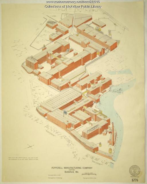
Architectural elevation map/drawing of Pepperell Manufacturing Company, Biddeford.
The colored drawing shows surrounding streets and buildings and the Saco River's course around the complex.
Outlines of the Saco-Lowell Shops buildings can be seen along the upper right hand side of the elevation.
Surveyed by H. W. Bunting for the Associated Factory Mutual Fire Insurance Companies Inspection Department, 184 High Street, Boston, Massachusetts.
About This Item
- Title: Pepperell Manufacturing fire insurance map, 1929
- Creator: H. W. Bunting
- Creation Date: 1929-10-10
- Subject Date: 1929-10-10
- Location: Biddeford, York County, ME
- Media: Ink on paper
- Dimensions: 67 cm x 53 cm
- Local Code: mcamap.0034
- Collection: Special Collections
- Object Type: Image
Cross Reference Searches
Standardized Subject Headings
- Fire insurance--Maps
- Architectural drawing
- Pepperell Manufacturing Company--Maps
- Saco River (N.H. and Me.)--Maps
People
Other Keywords
For more information about this item, contact:
McArthur Public LibraryPO Box 346, Biddeford, ME 04005
(207) 284-4181
Website
This Item is protected by copyright and/or related rights. No Permission is required to use the low-resolution watermarked image for educational use, or as allowed by the applicable copyright. For all other uses, permission is required.
Please post your comment below to share with others. If you'd like to privately share a comment or correction with MMN staff, please send us a message with this link.
