Keywords: Early map
- Historical Items (262)
- Tax Records (0)
- Architecture & Landscape (0)
- Online Exhibits (26)
- Site Pages (131)
- My Maine Stories (7)
- Lesson Plans (0)
Historical Items
These results include photographs, documents, letters, paintings, artifacts, and many other kinds of Maine related items from collections around the state and elsewhere.
Item 4319

Contributed by: Maine Historical Society Date: circa 1795 Location: Freeport; New Gloucester; Brunswick Media: Ink on paper
Item 7494

Map of New England and New York, ca. 1676
Contributed by: Maine Historical Society Date: circa 1676 Media: Ink on paper
Item 105628

Contributed by: Maine Historical Society Date: 1796 Media: Ink on paper
Item 9259

Early map of the Salmon Falls River in Lebanon, 1766
Contributed by: Maine Historical Society Date: 1766 Location: Lebanon Media: Ink on paper
Item 34148

Black Point, Scarborough, ca. 1741
Contributed by: Scarborough Historical Society & Museum Date: circa 1741 Location: Scarborough Media: Paper on cardboard
Item 4325

"Brunswick in the late Province of Mayne in New England," 1719
Contributed by: Maine Historical Society Date: 1718-01-28 Location: Brunswick Media: Ink on paper
Item 104782

Contributed by: Osher Map Library and Smith Center for Cartographic Education Date: 1793 Media: Engraving
Item 10832

Map by Francis Joseph Neptune, Cobscook River, 1798
Contributed by: Maine Historical Society Date: 1798 Media: Ink on paper
Item 58322

Copy of early Surry map, ca. 1880
Contributed by: Maine Historical Society Date: circa 1880 Location: Surry Media: Ink on paper
Item 17126
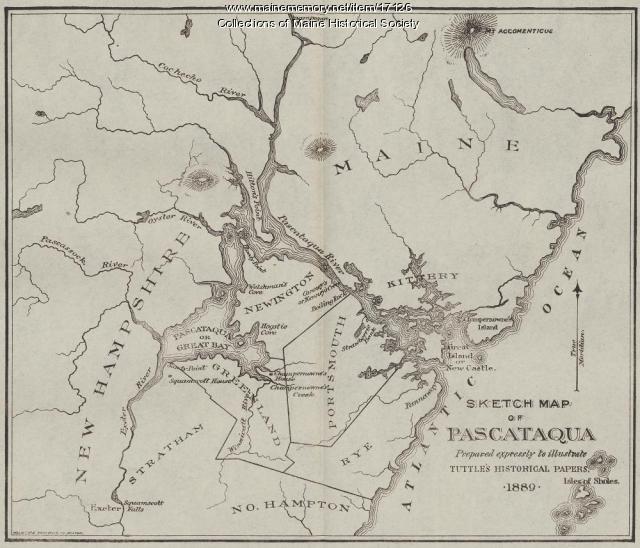
Sketch Map of Pascataqua, ca. 1690
Contributed by: Maine Historical Society Date: circa 1690 Media: Ink on paper, map
Item 5314

Plan of rivers of Saco and Kennebunk, 1731
Contributed by: Maine Historical Society Date: 1731 Media: Ink on paper
Item 22383

Contributed by: Maine Historical Society Date: 1727 Location: North Yarmouth; Falmouth; Freeport Media: Ink on paper
Item 11743

Contributed by: Maine Historical Society Date: 1742-11-12 Location: Harpswell Media: Ink on paper
Item 11714
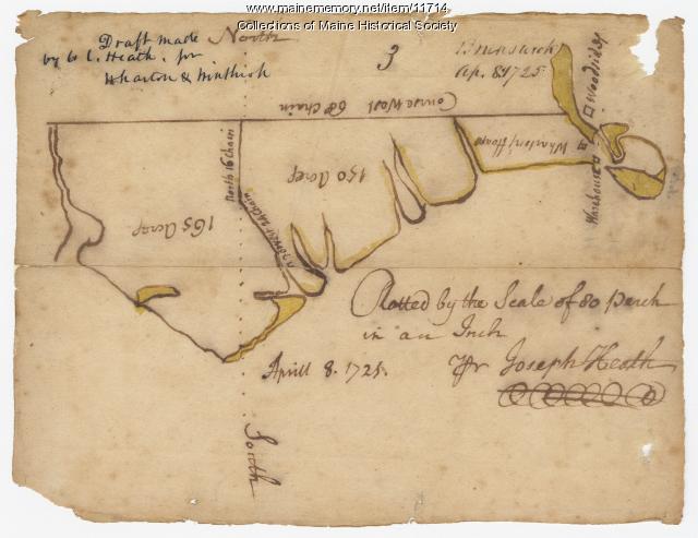
Contributed by: Maine Historical Society Date: 1725-04-08 Location: Brunswick Media: Ink on paper
Item 31237

Moses Banks Map, Scarborough, 1787
Contributed by: Scarborough Historical Society & Museum Date: 1787 Location: Scarborough Media: Paper and ink
Item 9166

Contributed by: Maine Historical Society Date: 1795 Media: Ink on paper
Item 11726

Contributed by: Maine Historical Society Date: 1795-05-29 Location: Brunswick; Durham; Freeport; Bath Media: Ink on paper
Item 11739
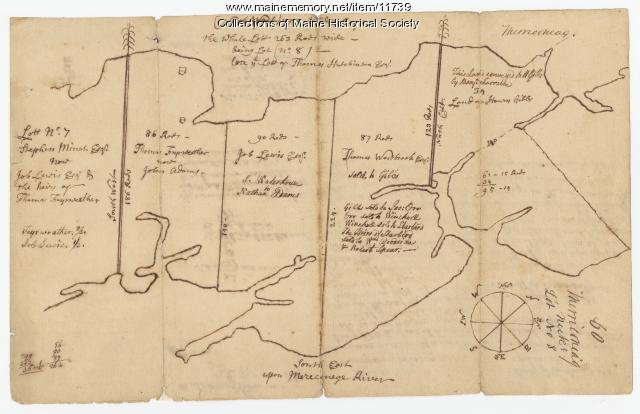
Contributed by: Maine Historical Society Date: 1771-06-17 Location: Harpswell Media: Ink on paper
Item 7540

Map of the New England Coast, 1610
Contributed by: Maine Historical Society Date: 1610 Media: Ink on paper
Item 10762

Enclosure map, Stroudwater, 1756
Contributed by: Maine Historical Society Date: 1756 Location: Portland; Westbrook Media: Ink on paper
Item 68865

Contributed by: Maine Historical Society Date: 1784 Location: Scarborough Media: Ink on paper
Item 12570

Foster's Neck, Georgetown, 1746
Contributed by: Maine Historical Society Date: 1746-11-01 Location: Georgetown Media: Ink on paper
Item 12399

Map of Draper's Claim, near Bath, 1795
Contributed by: Maine Historical Society Date: 1795 Media: Ink on paper
Item 109000

Dresden and Woolwich proposed border, ca. 1757
Contributed by: Maine Historical Society Date: circa 1757 Location: Woolwich; Dresden Media: Ink on paper
