Category: Nature & Geography, Maps
- Historical Items (576)
- Tax Records (0)
- Architecture & Landscape (0)
- Online Exhibits (6)
- Site Pages (10)
- My Maine Stories (1)
- Lesson Plans (1)
Historical Items
These results include photographs, documents, letters, paintings, artifacts, and many other kinds of Maine related items from collections around the state and elsewhere.
Item 9599

Mucalesa Mountain from Mucalesa Pond, Talcott Survey, 1841
Contributed by: Maine Historical Society Date: 1841 Media: Phototransparency
Item 10067

Contributed by: Maine Historical Society Date: circa 1780 Location: Gray Media: Ink on paper
Item 10522

Kennebec and Sheepscot rivers, 1868
Contributed by: Maine Historical Society Date: 1868 Media: Ink on paper
Item 10763
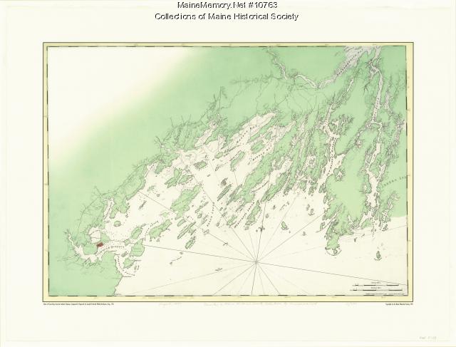
Chart of Casco Bay from the Atlantic Neptune, 1776
Contributed by: Maine Historical Society Date: circa 1776 Media: Ink on paper, map
Item 10833

Topographic map, Bath sheet, 1894
Contributed by: Maine Historical Society Date: 1894 Media: Map, ink on paper
Item 11285

Map of the Conquest of Katahdin, 1933
Contributed by: Baxter State Park Date: 1934 Location: Mt. Katahdin Twp. Media: Ink on paper, Photographic print
Item 11746

Contributed by: Maine Historical Society Date: 1749-07-04 Location: Brunswick; Harpswell Media: Ink on paper
Item 11775

Trelawny Black Point Deed, 1631
Contributed by: Maine Historical Society Date: 1631 Location: Scarborough; Scarborough Media: Ink on vellum
Item 11962

Contributed by: City of Portland Dept. of Public Works Date: circa 1813 Location: Portland Media: Ink on paper, map
Item 12133

Plan of that part of the county of Hancock lying on the Piscataquis.., 1806
Contributed by: Maine Historical Society Date: 1806 Media: Ink on parchment, map
Item 17401

Falls of the Du Loup, ca. 1841
Contributed by: Maine Historical Society Date: circa 1841 Media: Transparency
Item 17541

Map of Moosehead Lake, ca. 1870
Contributed by: Maine Historical Society Date: circa 1870 Media: Ink on paper
Item 17586

Map of Ragged Lake and Roach Pond, ca. 1893
Contributed by: Maine Historical Society Date: 1893 Media: Ink on paper
Item 22213

Contributed by: Aroostook County Historical and Art Museum Date: circa 1870 Location: Mechanic Falls Media: Print
Item 22490

Contributed by: Maine Historical Society Date: 1851 Location: Cape Elizabeth Media: Ink on paper, map
Item 28353
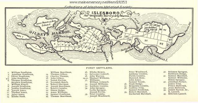
Warren Survey Map, Islesboro, ca. 1893
Contributed by: Islesboro Historical Society Date: circa 1799 Location: Islesboro Media: Ink on paper
Item 28910
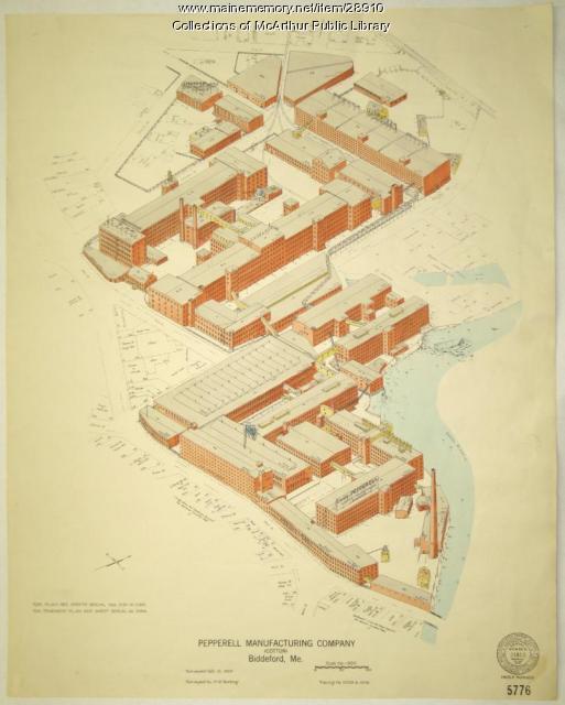
Pepperell Manufacturing fire insurance map, 1929
Contributed by: McArthur Public Library Date: 1929-10-10 Location: Biddeford Media: Ink on paper
Item 28982

Map of coastal Maine forts, 1723
Contributed by: Maine Historical Society Date: 1723 Media: Pencil on paper
Item 31099

Balloon view of Saco Bay, including Biddeford Pool, ca. 1880
Contributed by: McArthur Public Library Date: circa 1880 Location: Biddeford; Saco; Old Orchard Beach; Scarborough Media: Ink on paper
Item 33847

Champlain's map of Saco Bay and the Saco River, 1605
Contributed by: McArthur Public Library Date: 1605 Location: Biddeford; Saco Media: Photographic print
Item 59764

Kittery to York Beach electric railroad lines, ca. 1923
Contributed by: Seashore Trolley Museum Date: circa 1923 Location: York; Kittery Media: Ink on paper
Item 59770

Portland, South Portland, & Cape Elizabeth electric railroads, ca. 1941
Contributed by: Seashore Trolley Museum Date: circa 1941 Location: Portland Media: Ink on paper
Item 59772

Electric railroad route map, ca. 1933
Contributed by: Seashore Trolley Museum Date: circa 1933 Location: Portland; Falmouth; Yarmouth; Cumberland Media: Ink on paper
Item 59807

Gardiner to Augusta to Winthrop electric railroads, ca. 1932
Contributed by: Seashore Trolley Museum Date: circa 1932 Location: Augusta; Winthrop; Gardiner; Manchester Media: Ink on paper
