LC Subject Heading: Portland (ME)--Maps
- Historical Items (60)
- Tax Records (0)
- Architecture & Landscape (0)
- Online Exhibits (0)
- Site Pages (0)
- My Maine Stories (0)
- Lesson Plans (0)
Historical Items
These results include photographs, documents, letters, paintings, artifacts, and many other kinds of Maine related items from collections around the state and elsewhere.
Item 10887

Map from Hay's Guide to Portland and Motoring in Maine, 1928
Contributed by: Maine Historical Society Date: 1928 Media: Ink on paper, map
Item 25354

Plan of the town of New Portland, 1808
Contributed by: Maine Historical Society Date: 1808 Location: New Portland Media: Ink on paper, map
Item 35627

Map of Evergreen Cemetery, Portland, 1868
Contributed by: Maine Historical Society Date: 1868 Location: Portland Media: Ink on paper
Item 71166

Bird's-eye view of Portland, 1876
Contributed by: Boston Public Library Date: 1876 Location: Portland Media: Ink on paper, lithograph
Item 100726

Plan of Portland enhanced with school districts, ca. 1858
Contributed by: Maine Historical Society Date: circa 1858 Location: Portland Media: Lithograph with hand coloring
Item 100727

Contributed by: Maine Historical Society Date: 1826 Location: Portland Media: Watercolor and pen and ink, mounted on fabric
Item 105272

"Map of Portland and some places thereabout," 1928
Contributed by: Osher Map Library and Smith Center for Cartographic Education Date: 1928 Location: Portland Media: Lithograph
Item 105433

"Falmouth Neck, as it was when destroyed by Mowett," 1831
Contributed by: Osher Map Library and Smith Center for Cartographic Education Date: 1775-10-18 Location: Portland Media: Lithograph
Item 105920

Redline map of Portland and South Portland, 1935
Contributed by: Maine Historical Society Date: 1935-11-15 Location: Portland; South Portland Media: Ink on paper
Item 4173

Contributed by: Maine Historical Society Date: 1866 Location: Portland Media: Ink on paper
Item 4176

Falmouth Neck before burning, 1775
Contributed by: Maine Historical Society Date: 1775-10-18 Location: Portland Media: Paper
Item 5179

Eastern Cemetery, Portland, 1889
Contributed by: Maine Historical Society Date: 1889 Location: Portland Media: Blueprint
Item 5741

Detail from a Map of Portland Harbour and islands, 1825
Contributed by: Maine Historical Society Date: 1825 Location: Portland Media: Ink on paper, jpg
Item 14760

Map of Portland Harbour and islands, 1825
Contributed by: Maine Historical Society Date: 1825 Media: Ink on paper, map
Item 35626

Bird's-eye view of Deering, 1886
Contributed by: Maine Historical Society Date: 1886 Location: Portland Media: Ink on paper, lithograph
Item 176

Plan of Portland, engraved as a directory, 1852
Contributed by: Maine Historical Society Date: 1852 Location: Portland Media: Ink on paper
Item 6893

A new and correct plan of Portland, 1823
Contributed by: Maine Historical Society Date: 1823 Location: Portland Media: Ink on paper
Item 10884

Street guide of Portland, 1928
Contributed by: Maine Historical Society Date: 1928 Location: Portland Media: Ink on paper, map
Item 16128
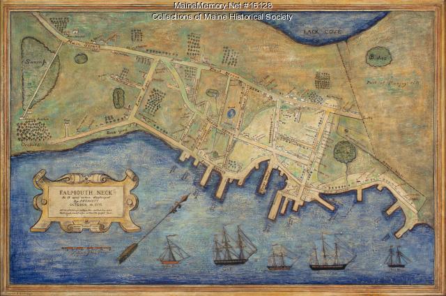
Mildred Burrage's painted map of 1775 destroyed Falmouth Neck, 1925
Contributed by: Maine Historical Society Date: 1775-10-18 Location: Portland Media: Painted gesso
Item 16876

Portland Harbor chart, ca. 1825
Contributed by: Maine Historical Society Date: circa 1825 Location: Portland Media: Ink on paper
Item 18722

Modern rendering of John Small's map of Falmouth, 1753
Contributed by: Maine Historical Society Date: 1753 Location: Falmouth Media: Map, ink on paper
Item 62538

General Plan for Western Promenade, Portland, 1905
Contributed by: Maine Historical Society Date: 1905 Location: Portland Media: Ink on paper
Item 100208

Plan of Falmouth as it appeared in 1775
Contributed by: Maine Historical Society Date: 1775 Location: Portland Media: Ink on paper
Item 148262

Map FOS 62, Portland, ca. 1804
Contributed by: Maine Historical Society Date: circa 1804 Location: Portland Media: ink on paper
