LC Subject Heading: Manuscript maps
- Historical Items (112)
- Tax Records (0)
- Architecture & Landscape (0)
- Online Exhibits (0)
- Site Pages (0)
- My Maine Stories (0)
- Lesson Plans (0)
Historical Items
These results include photographs, documents, letters, paintings, artifacts, and many other kinds of Maine related items from collections around the state and elsewhere.
Item 59811

Skowhegan, Norridgewock, & Madison electric railway lines, ca. 1928
Contributed by: Seashore Trolley Museum Date: circa 1928 Location: Norridgewock; Skowhegan Media: Ink on paper
Item 59812

Rockland, Thomaston & Camden electric railroad lines, ca. 1931
Contributed by: Seashore Trolley Museum Date: circa 1931 Location: Rockport; Rockland; Thomaston; Owls Head; Camden Media: Ink on paper
Item 68864

James Libby land in Scarborough, 1773
Contributed by: Maine Historical Society Date: 1773 Location: Scarborough Media: Ink and wash on paper
Item 68866

Libby River land, Scarborough, 1794
Contributed by: Maine Historical Society Date: 1794 Location: Scarborough; Scarborough Media: Ink on paper, map
Item 100208

Plan of Falmouth as it appeared in 1775
Contributed by: Maine Historical Society Date: 1775 Location: Portland Media: Ink on paper
Item 102068

"Tract of land lying in Poland," 1798
Contributed by: Maine Historical Society Date: 1798 Location: Auburn; Poland; Minot; Turner Media: Ink on paper
Item 104602

A plan of the District of Maine, 1795
Contributed by: Osher Map Library and Smith Center for Cartographic Education Date: 1795 Media: Ink on Paper
Item 108831

Contributed by: Maine Historical Society Date: 1774-03-29 Location: Vassalboro Media: Ink on paper
Item 110867

"Plan of a tract of land lying 15 English miles on each side of Kennebeck River," 1751
Contributed by: Maine Historical Society Date: 1751 Media: Ink on paper
Item 11923

Survey of Robert and John Donlop lots, Brunswick, 1757
Contributed by: Maine Historical Society Date: 1757 Location: Brunswick Media: Ink on paper
Item 11924

Lots on Maquoit Road, Brunswick, 1761
Contributed by: Maine Historical Society Date: 1761 Location: Brunswick Media: Ink on paper
Item 11925

Seven lots on the Androscoggin River, 1771
Contributed by: Maine Historical Society Date: 1771 Location: Brunswick; Topsham; Freeport; Durham Media: Ink on paper
Item 11926
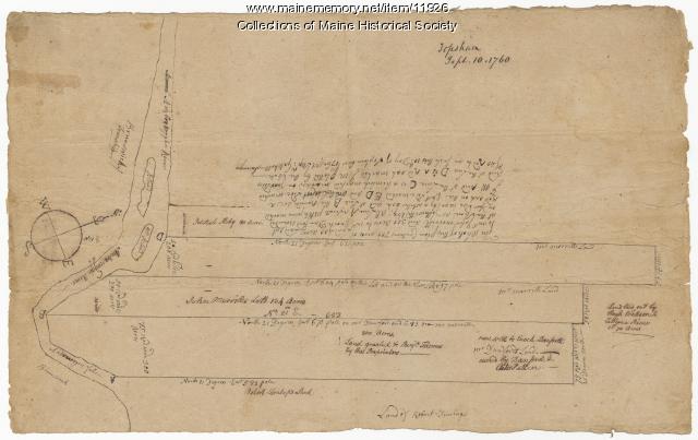
Morrill and Danforth lots, Topsham, 1760
Contributed by: Maine Historical Society Date: 1760-09-10 Location: Topsham Media: Ink on paper
Item 12197
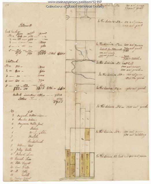
Division of the Tyng and Lowell estates, ca. 1760
Contributed by: Maine Historical Society Date: circa 1760 Media: Ink on paper
Item 12199

Plan of Cathance River, Bowdoinham, ca. 1740
Contributed by: Maine Historical Society Date: circa 1740 Location: Bowdoinham Media: Ink on paper
Item 12380

Tract granted to Samuel Goodwin, ca. 1757
Contributed by: Maine Historical Society Date: circa 1757 Location: Dresden Media: Ink on paper
Item 12381

Lot No. 39 of the Plymouth Company grant, June 1764
Contributed by: Maine Historical Society Date: 1764-06-27 Location: Winslow Media: Ink on paper
Item 12395

Map of Wesserunsett stream, 1790
Contributed by: Maine Historical Society Date: 1790-12-12 Location: Canaan; Canaan Media: Ink on paper
Item 12398

Early map of the Sheepscot River, 1816
Contributed by: Maine Historical Society Date: 1816-01-08 Location: Somerville; Whitefield; Windsor Media: Ink on paper
Item 12851

Contributed by: Maine Historical Society Date: 1798 Media: Ink on paper
Item 12852

Kennebec River above Fort Western, ca. 1800
Contributed by: Maine Historical Society Date: circa 1800 Media: Ink on paper
Item 12939

Henry May, James Larking lot, near the Sheepscot River, 1805
Contributed by: Maine Historical Society Date: 1805-11-25 Media: Ink on paper
Item 62539

Chart of the Penobscot River, ca. 1779
Contributed by: Maine Historical Society Date: 1779 Location: Castine Media: Ink on paper
Item 63561

O.O. Howard sketch of Gettysburg battlefield, 1899
Contributed by: Maine Historical Society Date: 1899 Location: Gettysburg Media: Ink on paper
