LC Subject Heading: Maine -- Maps, Manuscript.
- Historical Items (64)
- Tax Records (0)
- Architecture & Landscape (0)
- Online Exhibits (0)
- Site Pages (0)
- My Maine Stories (0)
- Lesson Plans (0)
Historical Items
These results include photographs, documents, letters, paintings, artifacts, and many other kinds of Maine related items from collections around the state and elsewhere.
Item 35622

Contributed by: Maine Historical Society Date: 1871 Location: Lovell Media: Ink on paper
Item 59765
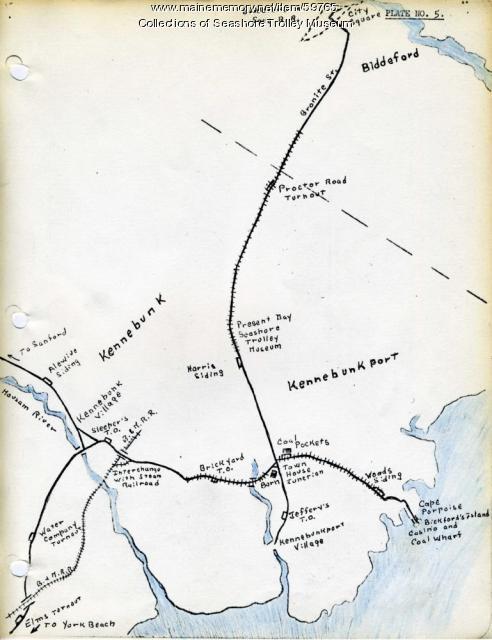
Kennebunk Village to Cape Porpoise electric railroads, ca. 1927
Contributed by: Seashore Trolley Museum Date: circa 1927 Location: Kennebunk; Cape Porpoise Media: Ink on paper
Item 59770

Portland, South Portland, & Cape Elizabeth electric railroads, ca. 1941
Contributed by: Seashore Trolley Museum Date: circa 1941 Location: Portland Media: Ink on paper
Item 6849

Contributed by: Maine Historical Society Date: 1794 Location: Augusta; Hallowell Media: Ink on paper
Item 20763

Penobscot River and Chesuncook Lake, 1820
Contributed by: Maine Historical Society Date: 1820 Media: Ink on paper
Item 7489

Nova Anglia, Novum Belgium et Virginia, ca. 1642
Contributed by: Maine Historical Society Date: circa 1642 Media: Map, ink on paper
Item 7490

Nova Belgica et Anglia Nova, ca. 1635
Contributed by: Maine Historical Society Date: circa 1635 Media: Map, ink on paper
Item 7492

Novi Belgii: Novaeque Angliae Nec Non partis Virginiae, ca. 1655
Contributed by: Maine Historical Society Date: circa 1655 Media: Map, ink on paper
Item 12558

Contributed by: Maine Historical Society Date: circa 1800 Location: Skowhegan Media: Ink on paper
Item 11743

Contributed by: Maine Historical Society Date: 1742-11-12 Location: Harpswell Media: Ink on paper
Item 6846

Plan of Saint Croix River, Calais, 1807
Contributed by: Maine Historical Society Date: 1807 Location: Calais Media: Ink on paper
Item 59801

Freeport electric railroads map, ca. 1929
Contributed by: Seashore Trolley Museum Date: circa 1929 Location: Freeport Media: Ink on paper
Item 59811

Skowhegan, Norridgewock, & Madison electric railway lines, ca. 1928
Contributed by: Seashore Trolley Museum Date: circa 1928 Location: Norridgewock; Skowhegan Media: Ink on paper
Item 104602

A plan of the District of Maine, 1795
Contributed by: Osher Map Library and Smith Center for Cartographic Education Date: 1795 Media: Ink on Paper
Item 148262

Map FOS 62, Portland, ca. 1804
Contributed by: Maine Historical Society Date: circa 1804 Location: Portland Media: ink on paper
Item 4316

Plan of J. Robinson lot, Topsham, 1761
Contributed by: Maine Historical Society Date: 1761 Location: Topsham Media: Ink on paper
Item 4319

Contributed by: Maine Historical Society Date: circa 1795 Location: Freeport; New Gloucester; Brunswick Media: Ink on paper
Item 20766

Manuscript Map of Moose River, Moosehead Lake, and Kennebeck Road, 1820
Contributed by: Maine Historical Society Date: 1820 Media: Ink on paper
Item 28982

Map of coastal Maine forts, 1723
Contributed by: Maine Historical Society Date: 1723 Media: Pencil on paper
Item 51266

A.W. Longfellow map of Presumpscot River, Windham, 1840
Contributed by: Maine Historical Society Date: 1840 Location: Westbrook Media: Ink on paper
Item 37701

Contributed by: Maine Historical Society Date: circa 1750 Media: Ink on paper
Item 7494

Map of New England and New York, ca. 1676
Contributed by: Maine Historical Society Date: circa 1676 Media: Ink on paper
Item 10097

Contributed by: The General Henry Knox Museum Date: 1786 Media: Ink on paper
Item 12196

Map of Kennebec Purchase lots, ca. 1750
Contributed by: Maine Historical Society Date: circa 1750 Media: Ink on paper
