Keywords: lot map
- Historical Items (205)
- Tax Records (0)
- Architecture & Landscape (3)
- Online Exhibits (15)
- Site Pages (38)
- My Maine Stories (2)
- Lesson Plans (0)
Historical Items
These results include photographs, documents, letters, paintings, artifacts, and many other kinds of Maine related items from collections around the state and elsewhere.
Item 96522

Baldwin and Sebago lot map, ca. 1820
Contributed by: Baldwin Historical Society Date: circa 1805 Location: Baldwin; Sebago Media: ink on paper
Item 108835

Plan of lots 1-10, Fairfield, 1782
Contributed by: Maine Historical Society Date: 1782-12-20 Location: Fairfield Media: Ink on paper
Item 108862

Survey of lots for Peter Brown, Georgetown, 1761
Contributed by: Maine Historical Society Date: 1761-01-12 Location: Bath Media: Ink on paper
Item 102069

Early map of Lewiston, Auburn and Minot, 1820
Contributed by: Maine Historical Society Date: 1820 Location: Lewiston; Auburn; Minot Media: Ink on paper
Item 105268

Contributed by: Osher Map Library and Smith Center for Cartographic Education Date: 1875 Location: Belfast Media: Lithograph
Item 105270

Manuscript map of Windham, 1872
Contributed by: Osher Map Library and Smith Center for Cartographic Education Date: circa 1740 Location: Windham Media: Ink on Paper
Item 18722

Modern rendering of John Small's map of Falmouth, 1753
Contributed by: Maine Historical Society Date: 1753 Location: Falmouth Media: Map, ink on paper
Item 31237

Moses Banks Map, Scarborough, 1787
Contributed by: Scarborough Historical Society & Museum Date: 1787 Location: Scarborough Media: Paper and ink
Item 23341

Map of Cushing Island, ca. 1888
Contributed by: Maine Historical Society Date: circa 1888 Location: Portland Media: Ink on paper, map
Item 109022

Disputed lot E, Brunswick, 1811
Contributed by: Maine Historical Society Date: 1811-09-03 Location: Brunswick Media: Ink on paper
Item 108858

Plan of 200 acres on the Western Side of Kennebec River, Frankfort Plantation, 1758
Contributed by: Maine Historical Society Date: 1758 Location: Dresden Media: Ink on paper
Item 12937
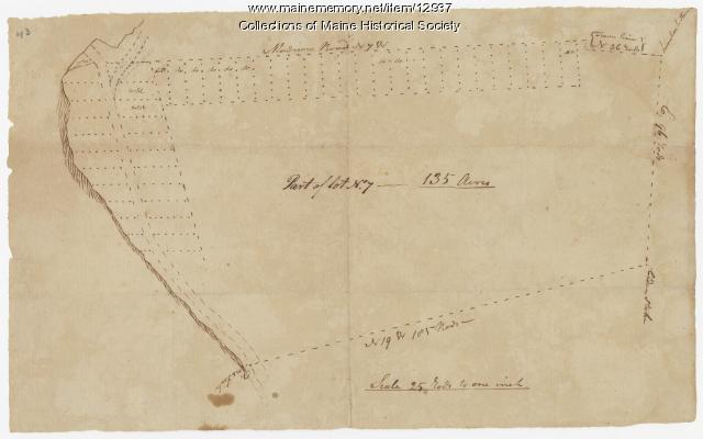
Map of lot no. 7, 135 acres on Madison Road, Skowhegan, ca. 1760
Contributed by: Maine Historical Society Date: circa 1760 Location: Skowhegan Media: Ink on paper
Item 11739
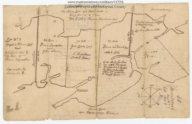
Contributed by: Maine Historical Society Date: 1771-06-17 Location: Harpswell Media: Ink on paper
Item 11730

Contributed by: Maine Historical Society Date: 1761-11-12 Location: Topsham Media: Ink on paper
Item 11743

Contributed by: Maine Historical Society Date: 1742-11-12 Location: Harpswell Media: Ink on paper
Item 68865

Contributed by: Maine Historical Society Date: 1784 Location: Scarborough Media: Ink on paper
Item 11725

Contributed by: Maine Historical Society Date: 1772 Location: Brunswick Media: Ink on paper
Item 11741

Contributed by: Maine Historical Society Date: 1742 Location: Harpswell Media: Ink on paper
Item 12396

Androscoggin River area map, 1771
Contributed by: Maine Historical Society Date: 1771-06-11 Location: Jay; Canton; Livermore Falls Media: Ink on paper
Item 12196

Map of Kennebec Purchase lots, ca. 1750
Contributed by: Maine Historical Society Date: circa 1750 Media: Ink on paper
Item 109025

Manuscript map of Topsham Lots, 1763
Contributed by: Maine Historical Society Date: 1763 Location: Topsham Media: Ink on paper
Item 11732

Contributed by: Maine Historical Society Date: circa 1760 Location: Topsham Media: Ink on paper
Item 12395

Map of Wesserunsett stream, 1790
Contributed by: Maine Historical Society Date: 1790-12-12 Location: Canaan; Canaan Media: Ink on paper
Item 102073

Map of Lewiston and Auburn, 1851
Contributed by: Maine Historical Society Date: 1851 Location: Lewiston; Auburn Media: Ink on paper
