Keywords: Political Map
- Historical Items (137)
- Tax Records (0)
- Architecture & Landscape (2)
- Online Exhibits (17)
- Site Pages (78)
- My Maine Stories (3)
- Lesson Plans (2)
Historical Items
These results include photographs, documents, letters, paintings, artifacts, and many other kinds of Maine related items from collections around the state and elsewhere.
Item 12936

Plan for the house of worship, Pownalborough, 1760
Contributed by: Maine Historical Society Date: 1760-12-12 Location: Dresden Media: Ink on paper
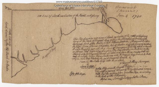
Item 11723

Contributed by: Maine Historical Society Date: 1747-07-06 Location: Brunswick Media: Ink on paper
Item 11925

Seven lots on the Androscoggin River, 1771
Contributed by: Maine Historical Society Date: 1771 Location: Brunswick; Topsham; Freeport; Durham Media: Ink on paper
Item 11749

Contributed by: Maine Historical Society Date: circa 1760 Location: Durham Media: Ink on paper
Item 5957

William Patten's land, Topsham, 1771
Contributed by: Maine Historical Society Date: 1771-04-12 Location: Bowdoinham Media: Ink on paper
Item 11748

Joshua Scottow's land boundary, Brunswick, 1737
Contributed by: Maine Historical Society Date: 1737-06-24 Location: Brunswick Media: Ink on paper
Item 11736

Lots on Cathance River, Topsham, 1764
Contributed by: Maine Historical Society Date: 1764-02-28 Location: Topsham Media: Ink on paper
Item 5343

Contributed by: Maine Historical Society Date: 1743 Location: Harpswell Media: Ink on paper
Item 11734

Hugh Wilson property, Topsham, 1762
Contributed by: Maine Historical Society Date: 1762-03-04 Location: Topsham Media: Ink on paper
Item 11746

Contributed by: Maine Historical Society Date: 1749-07-04 Location: Brunswick; Harpswell Media: Ink on paper
Item 22387

Contributed by: Maine Historical Society Date: 1898 Location: Portland Media: Ink on paper
Item 5958

Acter Patten's land, Topsham, 1765
Contributed by: Maine Historical Society Date: 1765-11-09 Location: Topsham Media: Ink on paper
Item 11719
Contributed by: Maine Historical Society Date: 1740-06-04 Location: Brunswick Media: Ink on paper
Item 11729

Land surveyed for Hugh Wilson, Topsham, 1761
Contributed by: Maine Historical Society Date: 1761-01-01 Location: Topsham Media: Ink on paper
Item 68864

James Libby land in Scarborough, 1773
Contributed by: Maine Historical Society Date: 1773 Location: Scarborough Media: Ink and wash on paper
Item 6848

Contributed by: Maine Historical Society Date: circa 1840 Location: Westbrook Media: Ink on paper
Item 11727

Cathance Millright's land, Topsham, 1759
Contributed by: Maine Historical Society Date: 1759-06-16 Location: Topsham Media: Ink on paper
Item 11735

Samuel Wilson lot, Topsham, 1762
Contributed by: Maine Historical Society Date: 1762 Location: Topsham Media: Ink on paper
Item 102767

Copy of a plan of lands on the west side of Madomack River, Waldoboro, 1774
Contributed by: Maine Historical Society Date: 1774 Location: Waldoboro Media: Ink on paper
Item 5320

Peletiah Haly's lot, Haly's Island, ca. 1750
Contributed by: Maine Historical Society Date: circa 1750 Location: Topsham; Brunswick Media: Ink on paper
Item 5890

Sara Cotta's lot, Brunswick, 1731
Contributed by: Maine Historical Society Date: 1731 Location: Brunswick Media: Ink on paper
Item 11733

Noyes, Skinner, and Merrill lots, Topsham, 1762
Contributed by: Maine Historical Society Date: 1762-01-05 Location: Topsham Media: Ink on paper
Item 11927

Thomas Wilson lot, Topsham, 1764
Contributed by: Maine Historical Society Date: 1764 Location: Topsham Media: Ink on paper
Item 11976

Plan of the Kennebec River describing the Plymouth patent, ca. 1719
Contributed by: Maine Historical Society Date: circa 1719 Media: Ink on paper
