Keywords: Maps, Manuscript.
- Historical Items (357)
- Tax Records (0)
- Architecture & Landscape (0)
- Online Exhibits (9)
- Site Pages (58)
- My Maine Stories (0)
- Lesson Plans (0)
Historical Items
These results include photographs, documents, letters, paintings, artifacts, and many other kinds of Maine related items from collections around the state and elsewhere.
Item 4319

Contributed by: Maine Historical Society Date: circa 1795 Location: Freeport; New Gloucester; Brunswick Media: Ink on paper
Item 116491

Manuscript map of Lake Superior to Lake of the Woods, ca. 1822
Contributed by: Maine Historical Society Date: circa 1820 Media: Ink on paper
Item 12570

Foster's Neck, Georgetown, 1746
Contributed by: Maine Historical Society Date: 1746-11-01 Location: Georgetown Media: Ink on paper
Item 110957

Manuscript map of Lake Erie, ca. 1818
Contributed by: Maine Historical Society Date: circa 1818 Media: Ink on paper
Item 4323
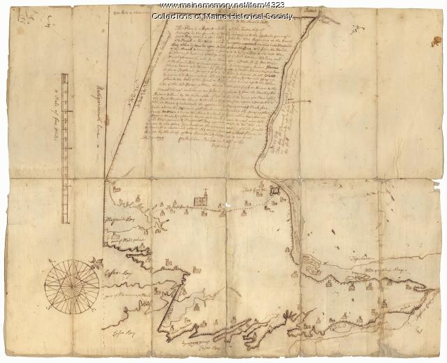
Contributed by: Maine Historical Society Date: 1738 Location: Brunswick; Harpswell; Topsham Media: Ink on paper
Item 4316

Plan of J. Robinson lot, Topsham, 1761
Contributed by: Maine Historical Society Date: 1761 Location: Topsham Media: Ink on paper
Item 116498

Manuscript survey of Lac La Croci, Vermillion Lake, ca. 1820
Contributed by: Maine Historical Society Date: circa 1820 Media: Ink on paper
Item 20766

Manuscript Map of Moose River, Moosehead Lake, and Kennebeck Road, 1820
Contributed by: Maine Historical Society Date: 1820 Media: Ink on paper
Item 116504

Manuscript Map of Lake Ontario, 1819
Contributed by: Maine Historical Society Date: 1819 Media: Ink on paper
Item 110958

Manuscript map of Lake Ontario, ca. 1820
Contributed by: Maine Historical Society Date: circa 1815 Media: Ink on paper
Item 18722

Modern rendering of John Small's map of Falmouth, 1753
Contributed by: Maine Historical Society Date: 1753 Location: Falmouth Media: Map, ink on paper
Item 16997

Map of Fryeburg Village in 1878
Contributed by: Fryeburg Historical Society Date: circa 1878 Location: Fryeburg Media: Map
Item 116523

Manuscript map of Cape Hurd, Lake Huron, ca. 1820
Contributed by: Maine Historical Society Date: circa 1820 Media: Ink on paper
Item 108853

A plan of a survey of sundry settlers' lots in Sheepscut Great Pond Settlement, 1802
Contributed by: Maine Historical Society Date: circa 1802 Location: Palermo Media: ink on paper
Item 12937
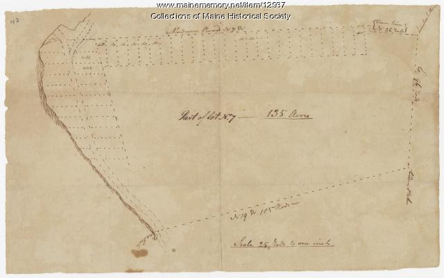
Map of lot no. 7, 135 acres on Madison Road, Skowhegan, ca. 1760
Contributed by: Maine Historical Society Date: circa 1760 Location: Skowhegan Media: Ink on paper
Item 108837

Copy of Thomas Johnston's Plan of part of the Eastern Shore, ca. 1770
Contributed by: Maine Historical Society Date: 1753 Media: Ink on paper
Item 8564

North shore, Lake Huron, ca. 1819
Contributed by: Maine Historical Society Date: circa 1819 Media: Ink on paper
Item 111022

A plane chart of Rainy Lake, ca. 1820
Contributed by: Maine Historical Society Date: circa 1820 Media: Ink on paper
Item 31237

Moses Banks Map, Scarborough, 1787
Contributed by: Scarborough Historical Society & Museum Date: 1787 Location: Scarborough Media: Paper and ink
Item 110949

Boundary survey between New Brunswick and Maine, 1842
Contributed by: Maine Historical Society Date: 1842 Media: Ink on paper
Item 22383

Contributed by: Maine Historical Society Date: 1727 Location: North Yarmouth; Falmouth; Freeport Media: Ink on paper
Item 102069

Early map of Lewiston, Auburn and Minot, 1820
Contributed by: Maine Historical Society Date: 1820 Location: Lewiston; Auburn; Minot Media: Ink on paper
Item 12398

Early map of the Sheepscot River, 1816
Contributed by: Maine Historical Society Date: 1816-01-08 Location: Somerville; Whitefield; Windsor Media: Ink on paper
Item 18728

Plan of Georgetown, Maine, 1839
Contributed by: Maine Historical Society Date: 1839 Location: Georgetown; Georgetown Media: Ink, pencil, watercolor, map
