Keywords: Land grants.
- Historical Items (460)
- Tax Records (0)
- Architecture & Landscape (1)
- Online Exhibits (34)
- Site Pages (89)
- My Maine Stories (4)
- Lesson Plans (1)
Historical Items
These results include photographs, documents, letters, paintings, artifacts, and many other kinds of Maine related items from collections around the state and elsewhere.
Item 108751

50 acres bargained, Leeds, 1834
Contributed by: Maine Historical Society Date: 1834-10-02 Location: Leeds Media: Ink on paper
Item 108848

Map and petition, Sandy River, 1798
Contributed by: Maine Historical Society Date: 1798 Location: New Vineyard; Farmington Media: Ink on paper
Item 6145

Joseph Frye's land deed for Fryeburg, 1763
Contributed by: Fryeburg Historical Society Date: 1763 Location: Fryeburg Media: Ink on paper
Item 12380

Tract granted to Samuel Goodwin, ca. 1757
Contributed by: Maine Historical Society Date: circa 1757 Location: Dresden Media: Ink on paper
Item 11454

Contributed by: Maine Historical Society Date: 1763-08-11 Location: Brunswick; Topsham Media: Ink on paper
Item 12567

Samuel Goodwin mill grant, Dresden, 1757
Contributed by: Maine Historical Society Date: 1757-10-24 Location: Dresden Media: Ink on paper
Item 12939

Henry May, James Larking lot, near the Sheepscot River, 1805
Contributed by: Maine Historical Society Date: 1805-11-25 Media: Ink on paper
Item 108752

Plan of William Libby's lot, Durham, 1819
Contributed by: Maine Historical Society Date: 1819-12-08 Location: Durham Media: Ink on paper
Item 108754

Plan excepting a road to Durham, 1821
Contributed by: Maine Historical Society Date: 1821-06-29 Location: Durham Media: Ink on paper
Item 12381

Lot No. 39 of the Plymouth Company grant, June 1764
Contributed by: Maine Historical Society Date: 1764-06-27 Location: Winslow Media: Ink on paper
Item 17660

John Pyles land petition, ca. 1675
Contributed by: Maine Historical Society Date: circa 1675 Media: Ink on paper
Item 105270

Manuscript map of Windham, 1872
Contributed by: Osher Map Library and Smith Center for Cartographic Education Date: circa 1740 Location: Windham Media: Ink on Paper
Item 11976

Plan of the Kennebec River describing the Plymouth patent, ca. 1719
Contributed by: Maine Historical Society Date: circa 1719 Media: Ink on paper
Item 11719
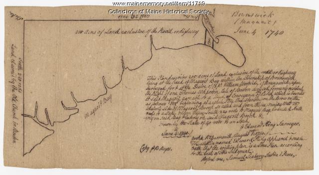
Contributed by: Maine Historical Society Date: 1740-06-04 Location: Brunswick Media: Ink on paper
Item 12854

Contributed by: Maine Historical Society Date: 1719-05-16 Media: Ink on paper
Item 122800

Plymouth Company Records, box 1/14, ca. 1755
Contributed by: Maine Historical Society Date: circa 1755 Location: Dresden Media: Ink on Paper
Item 58324

Mount Vernon land controversy, ca. 1806
Contributed by: Maine Historical Society Date: 1806 Location: Mount Vernon Media: Ink on paper
Item 6847

Plan of a division of land belonging to Dominicus Jordan, 1751
Contributed by: Maine Historical Society Date: 1751 Location: Cape Elizabeth Media: Ink on paper
Item 102252

Plan of burial ground, Minot, ca. 1835
Contributed by: Maine Historical Society Date: 1835 Location: Minot Media: Ink on paper
Item 102767

Copy of a plan of lands on the west side of Madomack River, Waldoboro, 1774
Contributed by: Maine Historical Society Date: 1774 Location: Waldoboro Media: Ink on paper
Item 12571

Contributed by: Maine Historical Society Date: 1810-06-15 Location: Windsor; Windsor Media: Ink on paper
Item 108758

Survey of part of lot 155, 1841
Contributed by: Maine Historical Society Date: 1841-06-17 Media: Ink on paper
Item 108846

Contributed by: Maine Historical Society Date: 1760-04-08 Location: West Bath Media: Ink on paper
Item 5890

Sara Cotta's lot, Brunswick, 1731
Contributed by: Maine Historical Society Date: 1731 Location: Brunswick Media: Ink on paper
