Keywords: Maine--Maps, Manuscript
- Historical Items (116)
- Tax Records (0)
- Architecture & Landscape (0)
- Online Exhibits (4)
- Site Pages (49)
- My Maine Stories (0)
- Lesson Plans (0)
Historical Items
These results include photographs, documents, letters, paintings, artifacts, and many other kinds of Maine related items from collections around the state and elsewhere.
Item 104782

Contributed by: Osher Map Library and Smith Center for Cartographic Education Date: 1793 Media: Engraving
Item 135882

Contributed by: Osher Map Library and Smith Center for Cartographic Education Date: 1761 Media: Ink on paper
Item 13074

Manuscript map of Kennebec River area, 1771
Contributed by: Maine Historical Society Date: 1771 Media: Ink on paper
Item 109025

Manuscript map of Topsham Lots, 1763
Contributed by: Maine Historical Society Date: 1763 Location: Topsham Media: Ink on paper
Item 108853

A plan of a survey of sundry settlers' lots in Sheepscut Great Pond Settlement, 1802
Contributed by: Maine Historical Society Date: circa 1802 Location: Palermo Media: ink on paper
Item 10832

Map by Francis Joseph Neptune, Cobscook River, 1798
Contributed by: Maine Historical Society Date: 1798 Media: Ink on paper
Item 4325

"Brunswick in the late Province of Mayne in New England," 1719
Contributed by: Maine Historical Society Date: 1718-01-28 Location: Brunswick Media: Ink on paper
Item 4318

Androscoggin River above Lewiston, ca. 1750
Contributed by: Maine Historical Society Date: circa 1750 Location: Turner; Livermore; Wayne; Leeds Media: Ink on paper
Item 109022

Disputed lot E, Brunswick, 1811
Contributed by: Maine Historical Society Date: 1811-09-03 Location: Brunswick Media: Ink on paper
Item 4319

Contributed by: Maine Historical Society Date: circa 1795 Location: Freeport; New Gloucester; Brunswick Media: Ink on paper
Item 20766

Manuscript Map of Moose River, Moosehead Lake, and Kennebeck Road, 1820
Contributed by: Maine Historical Society Date: 1820 Media: Ink on paper
Item 6846

Plan of Saint Croix River, Calais, 1807
Contributed by: Maine Historical Society Date: 1807 Location: Calais Media: Ink on paper
Item 4316

Plan of J. Robinson lot, Topsham, 1761
Contributed by: Maine Historical Society Date: 1761 Location: Topsham Media: Ink on paper
Item 110981

Contributed by: Maine Historical Society Date: 1817–1820 Media: Ink on paper
Item 10097

Contributed by: The General Henry Knox Museum Date: 1786 Media: Ink on paper
Item 4323
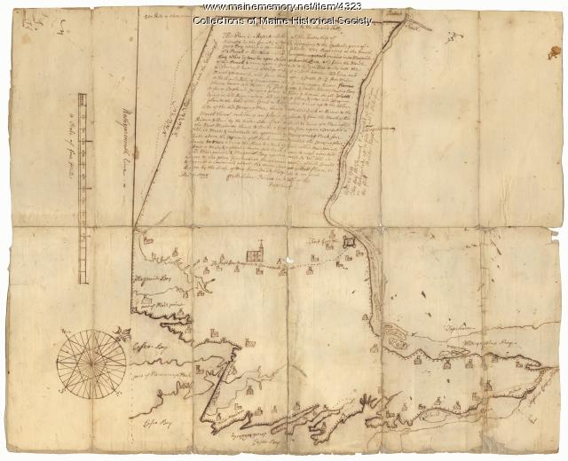
Contributed by: Maine Historical Society Date: 1738 Location: Brunswick; Harpswell; Topsham Media: Ink on paper
Item 12196

Map of Kennebec Purchase lots, ca. 1750
Contributed by: Maine Historical Society Date: circa 1750 Media: Ink on paper
Item 11730

Contributed by: Maine Historical Society Date: 1761-11-12 Location: Topsham Media: Ink on paper
Item 108765

Edward Little plan of lots, ca. 1820
Contributed by: Maine Historical Society Date: circa 1820 Media: Ink on paper
Item 6849

Contributed by: Maine Historical Society Date: 1794 Location: Augusta; Hallowell Media: Ink on paper
Item 11743

Contributed by: Maine Historical Society Date: 1742-11-12 Location: Harpswell Media: Ink on paper
Item 11731

William Patten's lot, Topsham, 1761
Contributed by: Maine Historical Society Date: 1761-11-24 Location: Topsham Media: Ink on paper
Item 11736

Lots on Cathance River, Topsham, 1764
Contributed by: Maine Historical Society Date: 1764-02-28 Location: Topsham Media: Ink on paper
Item 11737
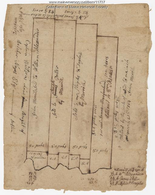
Contributed by: Maine Historical Society Date: 1764-04-07 Location: Topsham Media: Ink on paper
