Keywords: Maps, Manuscript.
- Historical Items (357)
- Tax Records (0)
- Architecture & Landscape (0)
- Online Exhibits (9)
- Site Pages (58)
- My Maine Stories (0)
- Lesson Plans (0)
Historical Items
These results include photographs, documents, letters, paintings, artifacts, and many other kinds of Maine related items from collections around the state and elsewhere.
Item 110967

Map of Islands on Lake Huron, ca. 1820
Contributed by: Maine Historical Society Date: circa 1820 Location: Drummond Media: Ink on paper
Item 18727

Plan of Georgetown, Maine, 1829
Contributed by: Maine Historical Society Date: 1829 Location: Georgetown Media: Ink, watercolor, map
Item 110981

Contributed by: Maine Historical Society Date: 1817–1820 Media: Ink on paper
Item 11965

Contributed by: City of Portland Dept. of Public Works Date: 1773 Location: Portland Media: Ink on paper, map
Item 11989

Plan of Ann (now Park) Street, Portland, ca. 1802
Contributed by: Maine Historical Society Date: circa 1802 Location: Portland Media: Pen, Ink and watercolor on paper, map
Item 11779

Plan of a section of Portland called The Oaks, ca. 1845
Contributed by: Maine Historical Society Date: circa 1845 Location: Portland Media: Ink on paper, map
Item 11743

Contributed by: Maine Historical Society Date: 1742-11-12 Location: Harpswell Media: Ink on paper
Item 11739
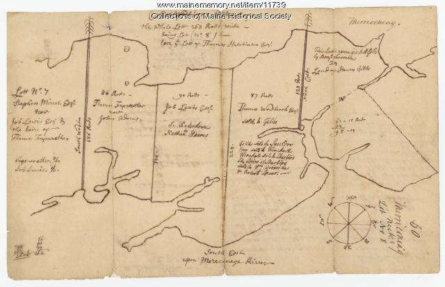
Contributed by: Maine Historical Society Date: 1771-06-17 Location: Harpswell Media: Ink on paper
Item 110895

Plan of the islands at the mouth of the River St. Clair, ca. 1823
Contributed by: Maine Historical Society Date: circa 1823 Media: Ink on paper
Item 10097

Contributed by: The General Henry Knox Museum Date: 1786 Media: Ink on paper
Item 58322

Copy of early Surry map, ca. 1880
Contributed by: Maine Historical Society Date: circa 1880 Location: Surry Media: Ink on paper
Item 12196

Map of Kennebec Purchase lots, ca. 1750
Contributed by: Maine Historical Society Date: circa 1750 Media: Ink on paper
Item 68866

Libby River land, Scarborough, 1794
Contributed by: Maine Historical Society Date: 1794 Location: Scarborough; Scarborough Media: Ink on paper, map
Item 12396

Androscoggin River area map, 1771
Contributed by: Maine Historical Society Date: 1771-06-11 Location: Jay; Canton; Livermore Falls Media: Ink on paper
Item 11730

Contributed by: Maine Historical Society Date: 1761-11-12 Location: Topsham Media: Ink on paper
Item 11726

Contributed by: Maine Historical Society Date: 1795-05-29 Location: Brunswick; Durham; Freeport; Bath Media: Ink on paper
Item 11714
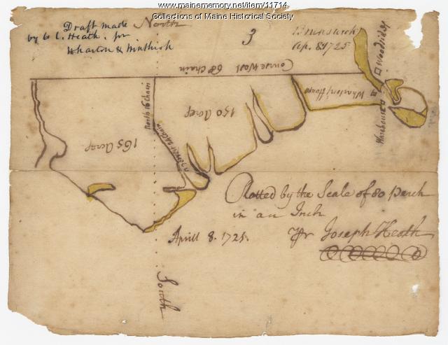
Contributed by: Maine Historical Society Date: 1725-04-08 Location: Brunswick Media: Ink on paper
Item 12133

Plan of that part of the county of Hancock lying on the Piscataquis.., 1806
Contributed by: Maine Historical Society Date: 1806 Media: Ink on parchment, map
Item 110900

Map detail for portions of Cornwall and Bug Islands, ca. 1820
Contributed by: Maine Historical Society Date: circa 1820 Location: Cornwall Island ; St. Regis Island Media: Graphite on paper
Item 6846

Plan of Saint Croix River, Calais, 1807
Contributed by: Maine Historical Society Date: 1807 Location: Calais Media: Ink on paper
Item 11724

Map of Brunswick near the Narrows, 1737
Contributed by: Maine Historical Society Date: 1737 Location: Brunswick; Topsham Media: Ink on paper
Item 5314

Plan of rivers of Saco and Kennebunk, 1731
Contributed by: Maine Historical Society Date: 1731 Media: Ink on paper
Item 110976

Manuscript survey of Indian Stream, New Hampshire, 1843-1844
Contributed by: Maine Historical Society Date: 1843–1844 Location: Pittsburg Media: Ink on paper
Item 108848

Map and petition, Sandy River, 1798
Contributed by: Maine Historical Society Date: 1798 Location: New Vineyard; Farmington Media: Ink on paper
