LC Subject Heading: Maps, Early
- Historical Items (112)
- Tax Records (0)
- Architecture & Landscape (0)
- Online Exhibits (0)
- Site Pages (0)
- My Maine Stories (0)
- Lesson Plans (0)
Historical Items
These results include photographs, documents, letters, paintings, artifacts, and many other kinds of Maine related items from collections around the state and elsewhere.
Item 12202

Plan of Samuel Goodwin's land, Dresden, ca. 1760
Contributed by: Maine Historical Society Date: circa 1760 Location: Woolwich; Dresden; Woolwich; Dresden Media: Ink on paper
Item 12567

Samuel Goodwin mill grant, Dresden, 1757
Contributed by: Maine Historical Society Date: 1757-10-24 Location: Dresden Media: Ink on paper
Item 12937
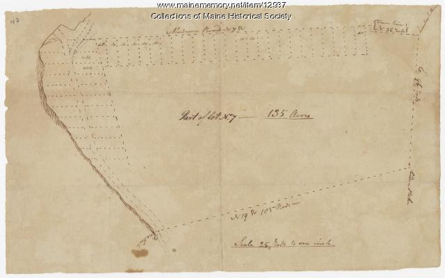
Map of lot no. 7, 135 acres on Madison Road, Skowhegan, ca. 1760
Contributed by: Maine Historical Society Date: circa 1760 Location: Skowhegan Media: Ink on paper
Item 108848

Map and petition, Sandy River, 1798
Contributed by: Maine Historical Society Date: 1798 Location: New Vineyard; Farmington Media: Ink on paper
Item 108862

Survey of lots for Peter Brown, Georgetown, 1761
Contributed by: Maine Historical Society Date: 1761-01-12 Location: Bath Media: Ink on paper
Item 11827
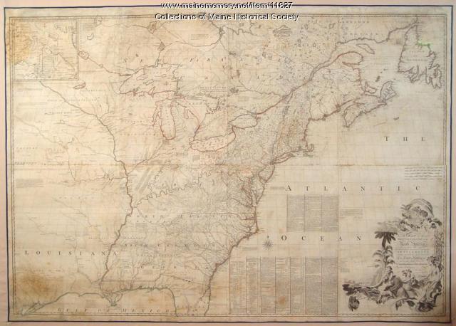
Map of the British and French North America, 1775
Contributed by: Maine Historical Society Date: 1755 Media: Ink on paper, map
Item 12199

Plan of Cathance River, Bowdoinham, ca. 1740
Contributed by: Maine Historical Society Date: circa 1740 Location: Bowdoinham Media: Ink on paper
Item 12395

Map of Wesserunsett stream, 1790
Contributed by: Maine Historical Society Date: 1790-12-12 Location: Canaan; Canaan Media: Ink on paper
Item 12851

Contributed by: Maine Historical Society Date: 1798 Media: Ink on paper
Item 68865

Contributed by: Maine Historical Society Date: 1784 Location: Scarborough Media: Ink on paper
Item 68873

Zebulon Libbey's land, Scarborough, 1769
Contributed by: Maine Historical Society Date: 1769 Location: Scarborough Media: Ink and wash on paper
Item 102071

Map of early Greene, Lewiston and Sabattus, ca. 1790
Contributed by: Maine Historical Society Date: circa 1790 Location: Sabattus; Greene Media: Ink on vellum
Item 109000

Dresden and Woolwich proposed border, ca. 1757
Contributed by: Maine Historical Society Date: circa 1757 Location: Woolwich; Dresden Media: Ink on paper
Item 110355

Survey of lots, Georgetown, 1793
Contributed by: Maine Historical Society Date: circa 1780 Location: Lubec Media: Ink on paper
Item 12126

Kennebec and Sagadahoc Rivers, 1755
Contributed by: Maine Historical Society Date: 1754 Media: Ink on paper
Item 12943

Plan of lots on the Sheepscot River, Alna, 1798
Contributed by: Maine Historical Society Date: 1759 Location: Alna Media: Ink on paper
Item 110867

"Plan of a tract of land lying 15 English miles on each side of Kennebeck River," 1751
Contributed by: Maine Historical Society Date: 1751 Media: Ink on paper
Item 4168

Contributed by: Maine Historical Society Date: 1690 Location: Portland Media: Ink on paper
Item 4323
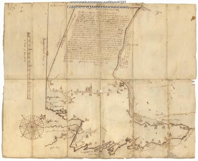
Contributed by: Maine Historical Society Date: 1738 Location: Brunswick; Harpswell; Topsham Media: Ink on paper
Item 11715
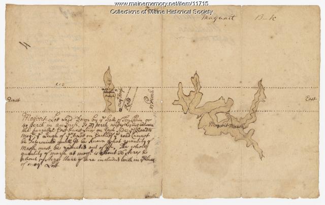
Plan of Maquoit Meadows, ca. 1720
Contributed by: Maine Historical Society Date: circa 1720 Location: Brunswick Media: Ink on paper
Item 11724

Map of Brunswick near the Narrows, 1737
Contributed by: Maine Historical Society Date: 1737 Location: Brunswick; Topsham Media: Ink on paper
Item 11976

Plan of the Kennebec River describing the Plymouth patent, ca. 1719
Contributed by: Maine Historical Society Date: circa 1719 Media: Ink on paper
Item 12203

Benjamin and Nehemiah Turner's plan containing 200 acres, Palermo, 1806
Contributed by: Maine Historical Society Date: 1806-06-18 Location: Palermo Media: Ink on paper
Item 12382

Plan of Kennebeck River, ca. 1765
Contributed by: Maine Historical Society Date: circa 1765 Media: Ink on paper
