LC Subject Heading: Maps
- Historical Items (607)
- Tax Records (0)
- Architecture & Landscape (2)
- Online Exhibits (0)
- Site Pages (0)
- My Maine Stories (0)
- Lesson Plans (0)
Historical Items
These results include photographs, documents, letters, paintings, artifacts, and many other kinds of Maine related items from collections around the state and elsewhere.
Item 16542

Rangley Lakes region map, 1876
Contributed by: Maine Historical Society Date: 1876 Media: Ink on paper
Item 17573

Lumbermen and Sportsmen's Map, 1894
Contributed by: Maine Historical Society Date: 1894 Media: Ink on paper, map
Item 23342

Contributed by: Maine Historical Society Date: circa 1850 Location: Thomaston Media: Ink on paper, map
Item 31883

Map of Cumberland County, 1880
Contributed by: North Yarmouth Historical Society Date: 1880 Media: Ink on paper
Item 105357

Map of the United States of America, 1821
Contributed by: Osher Map Library and Smith Center for Cartographic Education Date: 1821 Media: Engraving
Item 105520

Contributed by: Osher Map Library and Smith Center for Cartographic Education Date: circa 1907 Location: Bar Harbor Media: Lithograph
Item 4173

Contributed by: Maine Historical Society Date: 1866 Location: Portland Media: Ink on paper
Item 4181

Contributed by: Maine Historical Society Date: 1874 Media: Paper
Item 4182

Plan of Rascoheegan alias Parker's Island, 1759
Contributed by: Maine Historical Society Date: 1759 Location: Georgetown Media: Ink on paper
Item 10890

Contributed by: Maine Historical Society Date: 1909 Location: Portland Media: Ink on paper
Item 17574

Railroad map of Northern Maine, 1910
Contributed by: Maine Historical Society Date: 1910 Media: Ink on paper, map
Item 105443

A shopper's guide map of Portland, 1965
Contributed by: Osher Map Library and Smith Center for Cartographic Education Date: 1965 Location: Portland; South Portland; Cape Elizabeth Media: Lithograph
Item 4317

Cathance Mill lots, Topsham, 1759
Contributed by: Maine Historical Society Date: 1759-01-05 Location: Topsham Media: Ink on paper
Item 11945

Ramusio's Delle Nava Gationi, 1565
Contributed by: Maine Historical Society Date: 1565 Media: Ink on paper
Item 11966

Filling Back Cove, Portland, 1837-2003
Contributed by: City of Portland Dept. of Public Works Date: 1837 Location: Portland Media: Ink on paper, map
Item 11967

Back Cove fill history, Portland, 1837-2003
Contributed by: City of Portland Dept. of Public Works Date: 2003 Location: Portland Media: Ink on paper, map
Item 18727

Plan of Georgetown, Maine, 1829
Contributed by: Maine Historical Society Date: 1829 Location: Georgetown Media: Ink, watercolor, map
Item 18728

Plan of Georgetown, Maine, 1839
Contributed by: Maine Historical Society Date: 1839 Location: Georgetown; Georgetown Media: Ink, pencil, watercolor, map
Item 22215
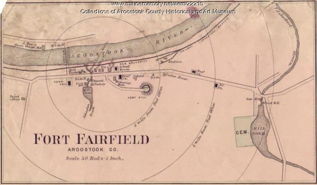
Map of Fort Fairfield, ca. 1870
Contributed by: Aroostook County Historical and Art Museum Date: circa 1870 Location: Fort Fairfield Media: Ink on paper
Item 22216

Contributed by: Aroostook County Historical and Art Museum Date: circa 1870 Location: Presque Isle Media: Ink on paper
Item 58322

Copy of early Surry map, ca. 1880
Contributed by: Maine Historical Society Date: circa 1880 Location: Surry Media: Ink on paper
Item 59770

Portland, South Portland, & Cape Elizabeth electric railroads, ca. 1941
Contributed by: Seashore Trolley Museum Date: circa 1941 Location: Portland Media: Ink on paper
Item 59772

Electric railroad route map, ca. 1933
Contributed by: Seashore Trolley Museum Date: circa 1933 Location: Portland; Falmouth; Yarmouth; Cumberland Media: Ink on paper
Item 62831

Contributed by: Strong Historical Society Date: circa 1861 Location: Strong Media: Ink on paper
