Keywords: town maps
- Historical Items (336)
- Tax Records (0)
- Architecture & Landscape (25)
- Online Exhibits (24)
- Site Pages (169)
- My Maine Stories (3)
- Lesson Plans (0)
Site Pages
These sites were created for each contributing partner or as part of collaborative community projects through Maine Memory. Learn about collaborative projects on MMN.
Site Page

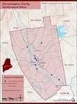
Farmington: Franklin County's Shiretown - Maps
"Farmington Town Map, 1794 Farmington Downtown Map, circa 1860 Farmington Topographical Map, 1924 Abbott Park Original Design Map "Paths" in Google…"
Site Page

Historic Hallowell - Train Wreck Map
"… Train Wreck Map Map X"
Site Page

Beyond Borders - Mapping Maine and the Northeast Boundary - Further Reading
"Edelson, S. Max. The New Map of Empire: How Britain Imagined America before Independence. Cambridge, MA: Harvard University Press, 2017."
Site Page
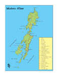
Islesboro--An Island in Penobscot Bay - Map of Islesboro
"… Map of Islesboro map of Islesboro X"
Site Page

Beyond Borders - Mapping Maine and the Northeast Boundary - Pejepscot Proprietors Papers, 1627‐1866
"Pejepscot Proprietors Papers, 1627‐1866 Map of lots on Maquoit & Merriconeeg, ca. 1719Maine Historical Society Coll."
Site Page

"… Historical Society Similarly, some of the maps within these collections contain vital placenames and locations, including documentation of…"
Site Page
Beyond Borders - Mapping Maine and the Northeast Boundary - Kennebec Proprietors Biographies
"He is listed on the John North map as surveyor. His fervent efforts kickstarted the company's incorporation and early activity around 1750."
Site Page

"… 1763-1842 British survey highlands map, ca. 1840Maine Historical Society Maine’s international border was the most bitterly contested…"
Site Page

Strong, a Mussul Unsquit village - The Bridge That Changed The Map
"The map was changed X But the map had already been changed. In 1861 the legislature had approved the petition of the residents of East Strong."
Site Page

"… their own hands, declaring in their own “Leagual Town Meeting” that the (still unincorporated) town would assume the power to revoke grants to…"
Site Page

"72 Kennebec Proprietors "Voted that Two Town Each of five Miles on the R Kennebeck & fifteen Miles Back..."Maine Historical Society The Kennebec…"
Site Page
"… least one major shareholder and the company clerk, made most of the decisions about managing the new, unincorporated towns on proprietary lands."
Site Page

"… as an agent for the company in their first town, present-day Dresden. At times, company agents clashed with their employers, disobeying directives…"
Site Page

Maine's Road to Statehood - Overview: Road to Statehood
"Header image, detail of A Map of the State of Maine (1820) by Moses Greenleaf. Contributed by Osher Map Library and Smith Center for Cartographic…"
Site Page

Maine's Road to Statehood - Maine in the 17th Century
"Maine in the 17th Century Map of New England and New York, ca. 1676 Largely an unexplored territory by European settlers, 17th century Maine…"
Site Page

Maine's Road to Statehood - The Missouri Compromise: A Moral Dilemma
"Map of the State of Maine, 1820Osher Map Library and Smith Center for Cartographic Education Within the United States, a greater sectional debate…"
Site Page

Maine's Road to Statehood - 1790s: A Growing Movement
"… effort soon died out.[16] District of Maine map, 1795 Drawn in 1795, this map promoted the separation of Maine from Massachusetts."
Site Page

Thomaston: The Town that Went to Sea - Early Shipbuilders - 1780s
"… Early Shipbuilders - 1780s Map of the Georges River, Thomaston, Maine 2009Thomaston Historical Society By the time Thomaston was…"
Site Page

Thomaston: The Town that Went to Sea - Thomaston Narrative
"Map of the New England Coast, 1610Maine Historical Society In 1605, after making landfall at Monhegan, Captain Waymouth re-anchored his ship…"
Site Page

Western Maine Foothills Region - Regional and Town History
"Google Maps tells us that the distance between Byron and Buckfield—respectively the northern and southern-most towns in RSU 10—is 43 miles, with a…"
Site Page

Farmington: Franklin County's Shiretown - The Brick Inn
"… Topographical Map of the Franklin County with Town of Farmington noted (map from Library of Congress)."
Site Page
Farmington: Franklin County's Shiretown - Brief History
"… States Geological Survey (USGS) Topographical Map of Farmington 1920 and 1922Farmington Historical Society The geographic location proved to be…"
Site Page
Farmington: Franklin County's Shiretown - Early Settlers
"… town records and to make a roller for the town maps. [1803-1804] So it appears he was a reputable businessman."
Site Page

Farmington: Franklin County's Shiretown - Education
"taught school in town. The Town was incorporated in 1794, and at the second town meeting of that year, the town raised a sum of money for “schooling”."
