Keywords: to 1800.
- Historical Items (723)
- Tax Records (0)
- Architecture & Landscape (1)
- Online Exhibits (35)
- Site Pages (222)
- My Maine Stories (4)
- Lesson Plans (0)
Historical Items
These results include photographs, documents, letters, paintings, artifacts, and many other kinds of Maine related items from collections around the state and elsewhere.
Item 110988

Contributed by: Maine Historical Society Date: circa 1820 Media: Ink on paper
Item 116514

St. John River boundary survey, Little Black River rapids, ca. 1843
Contributed by: Maine Historical Society Date: circa 1843 Media: Ink on paper
Item 8564

North shore, Lake Huron, ca. 1819
Contributed by: Maine Historical Society Date: circa 1819 Media: Ink on paper
Item 10833

Topographic map, Bath sheet, 1894
Contributed by: Maine Historical Society Date: 1894 Media: Map, ink on paper
Item 104600

Map of the District of Maine, 1815
Contributed by: Osher Map Library and Smith Center for Cartographic Education Date: 1815 Media: Engraving
Item 105270

Manuscript map of Windham, 1872
Contributed by: Osher Map Library and Smith Center for Cartographic Education Date: circa 1740 Location: Windham Media: Ink on Paper
Item 110905

Map of "Islands by Treaty of 1783," ca. 1817
Contributed by: Maine Historical Society Date: 1783 Media: Ink on paper
Item 110917

Bowen & Co. United States and British possessions map, British Columbia, 1846
Contributed by: Maine Historical Society Date: circa 1846 Location: Orcas Island; Vancouver Island Media: Ink on paper
Item 35628

Map of 1866 Portland Fire, 1866
Contributed by: Maine Historical Society Date: 1866-07-04 Location: Portland Media: Ink on paper
Item 100210

Anne L. Pierce sketch of Longfellow house site, Portland, ca. 1905
Contributed by: Maine Historical Society Date: circa 1823 Location: Portland Media: Ink on paper
Item 111022

A plane chart of Rainy Lake, ca. 1820
Contributed by: Maine Historical Society Date: circa 1820 Media: Ink on paper
Item 111049

Survey of Muddy Lake, ca. 1822
Contributed by: Maine Historical Society Date: circa 1822 Media: Ink on paper
Item 116500

Sketch of Drummond Island and straight between Lake Huron and Superior, ca. 1820
Contributed by: Maine Historical Society Date: circa 1820 Location: Sault St. Marie; Sault Ste. Marie Media: Ink on paper
Item 116522

Drummond's Island, Lesser and Greater Manitou, ca. 1820
Contributed by: Maine Historical Society Date: circa 1820 Media: Ink on paper
Item 116531

Part of the North Shore of Lake Huron, ca. 1820
Contributed by: Maine Historical Society Date: circa 1820 Media: Ink on paper
Item 11779

Plan of a section of Portland called The Oaks, ca. 1845
Contributed by: Maine Historical Society Date: circa 1845 Location: Portland Media: Ink on paper, map
Item 11963
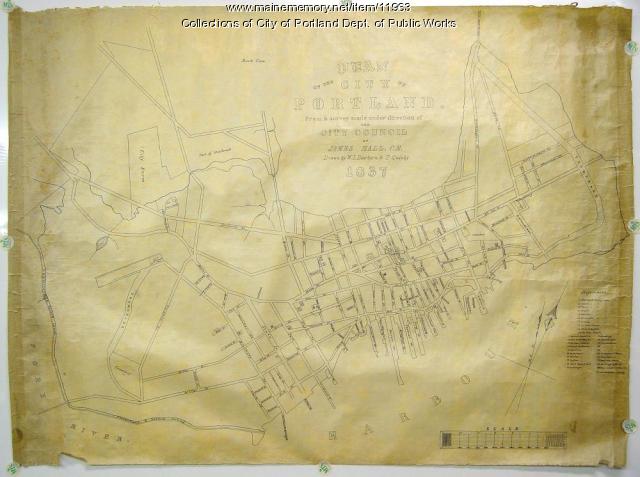
Plan of the City of Portland, 1837
Contributed by: City of Portland Dept. of Public Works Date: 1837 Location: Portland Media: Ink on paper, map
Item 22488

Southwest Branch of the St. John River, 1845
Contributed by: Maine Historical Society Date: 1845 Media: Ink on paper
Item 35625

Bird's eye view of the city of Portland, 1876
Contributed by: Maine Historical Society Date: 1876 Location: Portland Media: Ink on paper, lithograph
Item 63561

O.O. Howard sketch of Gettysburg battlefield, 1899
Contributed by: Maine Historical Society Date: 1899 Location: Gettysburg Media: Ink on paper
Item 110898

St. Regis Village at the river St. Lawrence, New York, ca. 1815
Contributed by: Maine Historical Society Date: circa 1815 Location: Waverly Media: Ink on paper
Item 116523

Manuscript map of Cape Hurd, Lake Huron, ca. 1820
Contributed by: Maine Historical Society Date: circa 1820 Media: Ink on paper
Item 7533

Map of Cape Elizabeth, Richmond Island area, 1884
Contributed by: Maine Historical Society Date: circa 1630 Location: Cape Elizabeth; Richmond Island Media: Ink on paper
Item 62831

Contributed by: Strong Historical Society Date: circa 1861 Location: Strong Media: Ink on paper
