Keywords: map making
- Historical Items (18)
- Tax Records (0)
- Architecture & Landscape (0)
- Online Exhibits (20)
- Site Pages (64)
- My Maine Stories (6)
- Lesson Plans (2)
Site Pages
These sites were created for each contributing partner or as part of collaborative community projects through Maine Memory. Learn about collaborative projects on MMN.
Site Page

"Map by Francis Joseph Neptune, Cobscook River, 1798Maine Historical Society The Beyond Borders portal makes accessible three of the Maine Historical…"
Site Page

"… 1763-1842 British survey highlands map, ca. 1840Maine Historical Society Maine’s international border was the most bitterly contested…"
Site Page

"This ill-defined boundary, based on an inaccurate map, was laid out in the Treaty of Paris in 1783. Maine Historical Society The European history of…"
Site Page

Beyond Borders - Mapping Maine and the Northeast Boundary - Project Partners
"… to extend the reach of such materials and make their intellectual content widely accessible." Any views, findings, conclusions, or recommendations…"
Site Page

"… not participate in companies’ day-to-day decision-making or shareholders’ meetings. Instead, they appeared in the record primarily when land titles…"
Site Page

"… only that we—as Wabanaki people—have always been making our own history, but that settlers have never fully recognized our self-determination or…"
Site Page

"… is between the often-distant proprietors, who make their claims over Wabanaki lands, sometimes through deeds (or purported deeds) signed with…"
Site Page

"… Goodwin found a copy of the Plymouth Colony Patent in 1744. The major shareholders began attempting to make the company claim a reality in 1749."
Site Page

"… by assuming the risk of moving to Maine, and making the company claim valuable, they deserved a greater share of it."
Site Page

"… roads, mills, and meetinghouses they built helped make the rest of the proprietors’ tracts more appealing to future purchasers."
Site Page

"… task of writing about historical documents and making them relevant to non-historians is often daunting."
Site Page

"… Indian deeds and title were only recognized as making it possible for European settlers—and European settlers only—to have full title to land, even…"
Site Page

Maine's Road to Statehood - Maine in the 17th Century
"Maine in the 17th Century Map of New England and New York, ca. 1676 Largely an unexplored territory by European settlers, 17th century Maine…"
Site Page

Maine's Road to Statehood - Overview: Road to Statehood
"Header image, detail of A Map of the State of Maine (1820) by Moses Greenleaf. Contributed by Osher Map Library and Smith Center for Cartographic…"
Site Page

Farmington: Franklin County's Shiretown - The Brick Inn
"… has been noted on this 1861 Walling Topographical Map of the Franklin County with Town of Farmington noted (map from Library of Congress)."
Site Page
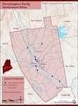
Farmington: Franklin County's Shiretown - Early Settlers
"… town records and to make a roller for the town maps. [1803-1804] So it appears he was a reputable businessman."
Site Page

Farmington: Franklin County's Shiretown - Brief History
"… Library, and Maine Historical Society 1794 map of FarmingtonFarmington Historical Society "Farmington is undoubtly one of the best…"
Site Page

Farmington: Franklin County's Shiretown - Agriculture
"Regional History Reprints. Originally published in 1846. Franklin Chronicle Newspapers. 1840-1918. Various magazine articles and maps."
Site Page

Farmington: Franklin County's Shiretown - Education
"Education Click the icon to see a map of the early schools of Farmington. X By Nancy Porter, Researcher and Page Creator With images from…"
Site Page

Maine's Road to Statehood - The American Revolution and Early Attempts at Separation - Page 1 of 2
"Did it make sense for Mainers to remain part of the Commonwealth? Some of the District's leading gentlemen—William Gorham and Stephen Longfellow III…"
Site Page

Maine's Road to Statehood - Turn of the Century to the War of 1812
"… its infant skin and entered a stage of maturity—making it ripe for statehood. Census of the District of Maine, 1810 Maine's population grew by…"
Site Page

"… lists the "toasts" as well as the names of those making them. They include some of the leading citizens of Farmington."
Site Page

Farmington: Franklin County's Shiretown - About Us
"… as we share the rich and dynamic history that makes Farmington a great place to live and work. 2008-2009 team members and dedicated volunteers…"
Site Page
Farmington: Franklin County's Shiretown - Measuring Rock
"… they stopped and stripped some basswood bark to make a chain (the tool used to measure land) that was one rod in length."
