Keywords: Survey Map
- Historical Items (188)
- Tax Records (0)
- Architecture & Landscape (51)
- Online Exhibits (12)
- Site Pages (65)
- My Maine Stories (0)
- Lesson Plans (0)
Historical Items
These results include photographs, documents, letters, paintings, artifacts, and many other kinds of Maine related items from collections around the state and elsewhere.
Item 15559

Co-cum-go-muc Mountains, ca. 1841
Contributed by: Maine Historical Society Date: circa 1841 Media: Transparency
Item 37703

Kennebec and Sagadahok rivers plan, 1755
Contributed by: Maine Historical Society Date: circa 1755 Media: Ink on paper
Item 116487

Canaan Corner, Northeast Boundary, ca. 1820
Contributed by: Maine Historical Society Date: circa 1820 Location: Canaan Media: Ink on paper
Item 116552

Lake Kaseiganagh east to Lake Superior, ca. 1825
Contributed by: Maine Historical Society Date: 1817–1827 Media: Ink on paper
Item 116554

Lake Kaseiganagh east to Lake Superior, duplicate, ca. 1825
Contributed by: Maine Historical Society Date: circa 1825 Media: Ink on paper
Item 116493

Crooked Lake and Lake Namacan, ca. 1820
Contributed by: Maine Historical Society Date: circa 1820 Media: Ink on paper
Item 11719
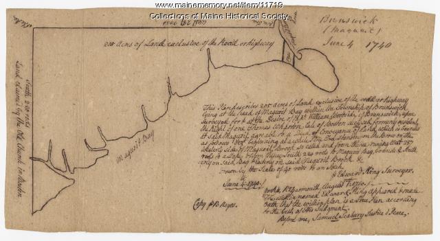
Contributed by: Maine Historical Society Date: 1740-06-04 Location: Brunswick Media: Ink on paper
Item 102767

Copy of a plan of lands on the west side of Madomack River, Waldoboro, 1774
Contributed by: Maine Historical Society Date: 1774 Location: Waldoboro Media: Ink on paper
Item 11733

Noyes, Skinner, and Merrill lots, Topsham, 1762
Contributed by: Maine Historical Society Date: 1762-01-05 Location: Topsham Media: Ink on paper
Item 17401

Falls of the Du Loup, ca. 1841
Contributed by: Maine Historical Society Date: circa 1841 Media: Transparency
Item 111004

Mouth of Detroit River, ca. 1820
Contributed by: Maine Historical Society Date: circa 1820 Media: Ink on paper
Item 15010

Co-cum-go-muc Mountains, ca. 1841
Contributed by: Maine Historical Society Date: circa 1841 Media: Transparency
Item 17397

Junction of the Du Loup River with the Chaudiere River, ca. 1841
Contributed by: Maine Historical Society Date: circa 1841 Media: Transparency
Item 17398

Sketch of country toward the St. John River, ca. 1841
Contributed by: Maine Historical Society Date: circa 1841 Media: Transparency
Item 17399

Otter Pond, Du Loup Water, 1841
Contributed by: Maine Historical Society Date: 1841-09-20 Media: Transparency
Item 17400

Contributed by: Maine Historical Society Date: 1841-10-20 Media: Transparency
Item 17402

Contributed by: Maine Historical Society Date: 1841 Media: Transparency
Item 12126

Kennebec and Sagadahoc Rivers, 1755
Contributed by: Maine Historical Society Date: 1754 Media: Ink on paper
Item 9602

Katahdin, as seen from Chamberlain Lake, 1839
Contributed by: Maine Historical Society Date: 1841 Media: Transparency
Item 148725

Plan of Township 3, Range 13, 1915
Contributed by: Maine Historical Society Date: 1915 Location: T3 R13 WELS Media: Ink on linen; hand coloring
Item 22488

Southwest Branch of the St. John River, 1845
Contributed by: Maine Historical Society Date: 1845 Media: Ink on paper
Item 6885

Plan of James Deering's Farm, Portland, 1843
Contributed by: Maine Historical Society Date: 1843 Location: Portland Media: Ink on paper
Item 58324

Mount Vernon land controversy, ca. 1806
Contributed by: Maine Historical Society Date: 1806 Location: Mount Vernon Media: Ink on paper
Item 68871

Second parish of Scarborough, 1798
Contributed by: Maine Historical Society Date: 1798 Location: Scarborough Media: Ink on paper
