Keywords: Street maps
- Historical Items (89)
- Tax Records (0)
- Architecture & Landscape (39)
- Online Exhibits (17)
- Site Pages (62)
- My Maine Stories (2)
- Lesson Plans (0)
Site Pages
These sites were created for each contributing partner or as part of collaborative community projects through Maine Memory. Learn about collaborative projects on MMN.
Site Page

Bath's Historic Downtown - 94 Front Street
"… in the early 1850s, according to the 1858 map of Bath, and city tax records, David Tilden Stinson rented the location from Oliver Moses, running a…"
Site Page

Beyond Borders - Mapping Maine and the Northeast Boundary - Kennebec Proprietors Biographies
"He is listed on the John North map as surveyor. His fervent efforts kickstarted the company's incorporation and early activity around 1750."
Site Page

Cumberland & North Yarmouth - "Main Streets" of North Yarmouth and Cumberland
"1871 North Yarmouth Historical Society Locating the old houses of Cumberland map, by Hope Dilloway, 1989Prince Memorial Library"
Site Page
"… meeting at the Royall Exchange Tavern on King Street in Boston. X While claiming ownership to hundreds of thousands of acres in Maine, most of…"
Site Page

"Northeast Harbor Village Map, ca. 1955Northeast Harbor Library The Future That Northeast Harbor is in economic decline, there is no doubt."
Site Page

Bath's Historic Downtown - The Customs House
"1901Patten Free Library According to the 1851 map of Bath, three separate buildings occupied the property where the Customs House was later built."
Site Page

Bath's Historic Downtown - Intersection of Centre and Washington
"According to several city maps, around 1910, the church had a vestry added to it. In 1890, a large organ was purchased for the church."
Site Page

Bath's Historic Downtown - History Overview
"Throughout the nineteenth century, as the lowest of these areas were filled in and Commercial Street was added to the east of Front Street, the…"
Site Page

Farmington: Franklin County's Shiretown - The Brick Inn
"… has been noted on this 1861 Walling Topographical Map of the Franklin County with Town of Farmington noted (map from Library of Congress)."
Site Page
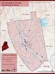
Farmington: Franklin County's Shiretown - Early Settlers
"Early Settlers Click the icon for a map of the locations of early settler's homesteads X By Nancy Porter, Researcher & Page Creator With…"
Site Page

Farmington: Franklin County's Shiretown - Brief History
"… Library, and Maine Historical Society 1794 map of FarmingtonFarmington Historical Society "Farmington is undoubtly one of the best…"
Site Page

Farmington: Franklin County's Shiretown - Education
"Education Click the icon to see a map of the early schools of Farmington. X By Nancy Porter, Researcher and Page Creator With images from…"
Site Page
Bath's Historic Downtown - Project Resources
"… 1894, “History of Bath and Environs, 1607-1894.” Maps Map of Part of the Town of Bath, A. Hammett, circa 1830. City of Bath, Lincoln County, Maine."
Site Page

Farmington: Franklin County's Shiretown - Farmington Public Library, 1916
"Notice the unpaved street, the wooden fences, and the elm trees, which have long since been removed, due to the Dutch elm disease, which was…"
Site Page

Bath's Historic Downtown - Project Overview
"Students attempted to fill in blank maps of the city, list as many facts as they could recall, and pose thoughtful questions on topics that they were…"
Site Page

"Located at 4 Academy Street in Farmington. The woman in the photograph is Lydia Abbott Titcomb. View additional information about this item on the…"
Site Page
Farmington: Franklin County's Shiretown - Meeting House Park
"(And now you know that Church Street is named for John Church and not the North Church at the east end of the street.) The Meeting House became a…"
Site Page

Farmington: Franklin County's Shiretown - North Church
"… purchased the lot on the northeast corner of High Street and Court Street and built the North Church in 1973."
Site Page
Farmington: Franklin County's Shiretown - Railroad into the Village
"At the intersection of the street with Broadway, and in fact from thence to the stone culvert, the road has been bullied and rendered dangerous."
Site Page
Farmington: Franklin County's Shiretown - Chester Greenwood
"… neighborhood near his home and with it, came a street that still bears his name. And he supported education, presumably because he didn’t have a…"
Site Page

"… Village with two of his daughters on Anson Street. The Titcomb House burned down around 1945."
Site Page

Farmington: Franklin County's Shiretown - The Abbott School
"… and purchased the Little Blue property across the street from Few Acres, and built a cottage there, where he continued his writing."
Site Page

Historic Hallowell - Historic Hallowell Resources and Links
"… Historic Maps Hallowell, Kennebec Co., Maine (sheet 1, index) by Sanborn-Perris Map Company from 1890 In the collection of The David Rumsey…"
Site Page

Thomaston: The Town that Went to Sea - Shipbuilding Declines - 1857 to 1861
"… Maine 1855Thomaston Historical Society Maps from 1855 to 1875 identify shipyards on Water Street under the following names: Robinson, McCallum…"
