Keywords: Penobscot Bay
- Historical Items (134)
- Tax Records (0)
- Architecture & Landscape (0)
- Online Exhibits (25)
- Site Pages (40)
- My Maine Stories (0)
- Lesson Plans (0)
Site Pages
These sites were created for each contributing partner or as part of collaborative community projects through Maine Memory. Learn about collaborative projects on MMN.
Site Page

"(editor), Penobscot The Forest, River and Bay. Island Institute, 1996. Surry's Centennial Souvenir, 1903. Varney, George J."
Site Page

Islesboro--An Island in Penobscot Bay - Our Resources
"… Affordable Property, PO Box 206, 376 West Bay Road, 734.2299 Islesboro Community Center, PO Box 265, 103 Pendleton Point Road, 734.8200…"
Site Page

Islesboro--An Island in Penobscot Bay - Water Transportation
"… to or from nearby towns on this side of Penobscot Bay such as Belfast or Camden. One could travel by steamboat from Islesboro to Rockland and…"
Site Page
Islesboro--An Island in Penobscot Bay - Historical Overview
"… Captain Benjamin Church arrived in Penobscot Bay with a company of men and landed on what came to be known as 700 Acre Island, a small island near…"
Site Page

Islesboro--An Island in Penobscot Bay - Early Settlements
"… of Maine dividing East and West Penobscot Bays. Early settlers arrived by various seacraft (or by sleigh over frozen water) bringing with them all…"
Site Page

Islesboro--An Island in Penobscot Bay - Businesses and Cottage Industries
"… island of Islesboro, located in the Penobscot Bay, has a long and rich history, as one of the last coastal areas to be settled, in the mid 1760s."
Site Page

View collections, facts, and contact information for this Contributing Partner.
Site Page

Surry by the Bay - History of Surry
"… back from the rugged shores of a beautiful bay. No echo of human industry to break the silence of the savage region, only the red man and his wild…"
Site Page

Surry by the Bay - Early Twentieth Century
"… the code name Esther 74, was erected at Morgan's Bay. Surry volunteers maintained all night vigils in search of German boats and submarines."
Site Page

Islesboro--An Island in Penobscot Bay - Summer Resorts
"Bay View House Booklet, Islesboro, ca. 1920Islesboro Historical Society As was true at Ryder’s Cove, there were year-round residents at Hewes Point…"
Site Page

Life on a Tidal River - Four Famous Bangorians
"… graduated in 1874, she started to practice in the Bay Area back in California. After that she applied back to San Francisco Medical Society in…"
Site Page

Islesboro--An Island in Penobscot Bay - Schools
"Schools map of Islesboro Text by Ruth Hartley School Bell, Islesboro, ca. 1880Islesboro Historical Society After incorporating as a town in…"
Site Page
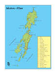
Islesboro--An Island in Penobscot Bay - Map of Islesboro
"… Map of Islesboro map of Islesboro X"
Site Page
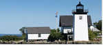
Islesboro--An Island in Penobscot Bay - About Us
"About Us Grindle Point Lighthouse X TEAM ISLESBORO’S PROCESS From the start, Islesboro stressed student participation and community involvement."
Site Page

Blue Hill, Maine - Blue Hill Spearheads Development on the Downeast Coast
"… to be settled by the English was the Penobscot Bay region including what is now known as the town of Blue Hill."
Site Page
Blue Hill, Maine - Project Sources
"… of the Mid-Maine Coast: Blue Hill and Penobscot Bays, 1982. —(LI) O’Leary, W.M. Maine Sea Fisheries: The Rise and Fall of a Native Industry…"
Site Page

"A handful of land schemes in Passamaquoddy Bay sprang up under the jurisdiction of Nova Scotia in the late 1760s and 1770s, but they were small, and…"
Site Page

Blue Hill, Maine - Educating Blue Hill
"… eight and nine merged into the "head of the bay district" in 1848. Like other schoolhouses, in the earlier years the school had had a wide age…"
Site Page

"… called the Waldo Patent) to the west of Penobscot Bay. For these proprietors and others like them who spearheaded smaller schemes, landownership…"
Site Page

"… of the rivers that flowed into Passamaquoddy Bay was actually the St. Croix intended in 1783. It also agreed upon the interior source (or…"
Site Page

"Ranco, PhD (Penobscot), Fall 2022 The collections in the Beyond Borders project are important and significant to many audiences, including, and…"
Site Page

"“A “Labyrinth of Uncertainties”: Penobscot River Islands, Land Assignments, and Indigenous Women Proprietors in Nineteenth-Century Maine.” The…"
Site Page

"… between colonists and the Wabanaki in 1736, a Penobscot couple visited an English household to relay a warning."
Site Page

"… where the General Court in Boston sided with the Penobscots in the 1730s, against local settlers, because of Dummer’s Treaty."
