Keywords: Pejepscot Proprietors
- Historical Items (142)
- Tax Records (0)
- Architecture & Landscape (0)
- Online Exhibits (6)
- Site Pages (49)
- My Maine Stories (0)
- Lesson Plans (0)
Historical Items
These results include photographs, documents, letters, paintings, artifacts, and many other kinds of Maine related items from collections around the state and elsewhere.
Item 108768

Survey of lot no. 90, Durham, ca. 1790
Contributed by: Maine Historical Society Date: circa 1790 Location: Durham Media: Ink on paper
Item 11972

Contributed by: Maine Historical Society Date: circa 1740 Location: Harpswell Media: Ink on paper
Item 108766

Plan of lot no. 1, Lewiston, ca. 1800
Contributed by: Maine Historical Society Date: circa 1800 Location: Lewiston Media: Ink on paper
Item 4323
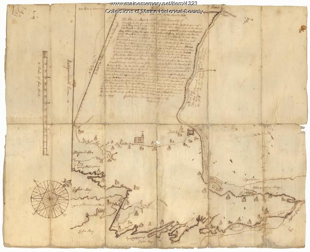
Contributed by: Maine Historical Society Date: 1738 Location: Brunswick; Harpswell; Topsham Media: Ink on paper
Item 11743

Contributed by: Maine Historical Society Date: 1742-11-12 Location: Harpswell Media: Ink on paper
Item 11731

William Patten's lot, Topsham, 1761
Contributed by: Maine Historical Society Date: 1761-11-24 Location: Topsham Media: Ink on paper
Item 108751

50 acres bargained, Leeds, 1834
Contributed by: Maine Historical Society Date: 1834-10-02 Location: Leeds Media: Ink on paper
Item 108756

Plot adjacent to Peables' fence, ca. 1800
Contributed by: Maine Historical Society Date: circa 1800 Media: Ink on paper
Item 102069

Early map of Lewiston, Auburn and Minot, 1820
Contributed by: Maine Historical Society Date: 1820 Location: Lewiston; Auburn; Minot Media: Ink on paper
Item 11725

Contributed by: Maine Historical Society Date: 1772 Location: Brunswick Media: Ink on paper
Item 11720

Contributed by: Maine Historical Society Date: 1740-09-29 Location: Brunswick Media: Ink on paper
Item 11729

Land surveyed for Hugh Wilson, Topsham, 1761
Contributed by: Maine Historical Society Date: 1761-01-01 Location: Topsham Media: Ink on paper
Item 109025

Manuscript map of Topsham Lots, 1763
Contributed by: Maine Historical Society Date: 1763 Location: Topsham Media: Ink on paper
Item 4324

Androscoggin and Kennebec Rivers, ca. 1720
Contributed by: Maine Historical Society Date: circa 1720 Media: Ink on paper
Item 108760

Survey of lots near Great and Little Androscoggin Rivers, ca. 1800
Contributed by: Maine Historical Society Date: circa 1800 Media: Ink on paper
Item 108755

Land of Samuel Sylvester, Prout's Gore, 1813
Contributed by: Maine Historical Society Date: 1813-11-05 Location: Freeport Media: Ink on paper
Item 108750

Contributed by: Maine Historical Society Date: 1834-10-02 Location: Leeds Media: Ink on paper
Item 108753

Plan of the Bracket Lots, Androscoggin County, ca. 1800
Contributed by: Maine Historical Society Date: circa 1800 Location: Durham Media: Ink on paper
Item 108758

Survey of part of lot 155, 1841
Contributed by: Maine Historical Society Date: 1841-06-17 Media: Ink on paper
Item 108757

Survey of land eastern side of No Name Pond, Lewiston, ca. 1800
Contributed by: Maine Historical Society Date: circa 1800 Location: Lewiston Media: Ink on paper
Item 12408

John Patten lot, Topsham, ca. 1760
Contributed by: Maine Historical Society Date: circa 1760 Location: Topsham Media: Ink on paper
Item 109026

Abagadassat Mill lots, Bowdoinham, 1755
Contributed by: Maine Historical Society Date: 1755 Location: Bowdoinham Media: Ink on paper
Item 108759

Survey of land in Poland, 1842
Contributed by: Maine Historical Society Date: 1842 Location: Poland Media: Ink on paper
Item 37701

Contributed by: Maine Historical Society Date: circa 1750 Media: Ink on paper
