Keywords: Historical Map
- Historical Items (586)
- Tax Records (0)
- Architecture & Landscape (209)
- Online Exhibits (31)
- Site Pages (171)
- My Maine Stories (2)
- Lesson Plans (5)
Site Pages
These sites were created for each contributing partner or as part of collaborative community projects through Maine Memory. Learn about collaborative projects on MMN.
Site Page
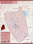
Farmington: Franklin County's Shiretown - Early Settlers
"Early Settlers Click the icon for a map of the locations of early settler's homesteads X By Nancy Porter, Researcher & Page Creator With…"
Site Page

Farmington: Franklin County's Shiretown - Brief History
"… Library, and Maine Historical Society 1794 map of FarmingtonFarmington Historical Society "Farmington is undoubtly one of the best…"
Site Page

Bath's Historic Downtown - Intersection of Centre and Washington
"According to several city maps, around 1910, the church had a vestry added to it. In 1890, a large organ was purchased for the church."
Site Page

Farmington: Franklin County's Shiretown - Agriculture
"Regional History Reprints. Originally published in 1846. Franklin Chronicle Newspapers. 1840-1918. Various magazine articles and maps."
Site Page

View collections, facts, and contact information for this Contributing Partner.
Site Page

Farmington: Franklin County's Shiretown - Education
"Education Click the icon to see a map of the early schools of Farmington. X By Nancy Porter, Researcher and Page Creator With images from…"
Site Page

Frye Island Historical Society
View collections, facts, and contact information for this Contributing Partner.
Site Page

Scarborough: They Called It Owascoag - Historical Overview - Page 1 of 4
"Historical Overview Map of Scarborough with MarshlandScarborough Historical Society & Museum Scarborough: They Called it Owascoag Text by…"
Site Page

View collections, facts, and contact information for this Contributing Partner.
Site Page

Historic Hallowell - Thomas Bond House
"The 1885 map of Hallowell shows the occupant of the Thomas Bond House as C.A. Page. Charles A. Page was a manufacturer/dealer of saddle, harnesses…"
Site Page

Maine's Road to Statehood - After the War: The First Victory for Separationists
"Maine Historical Society The War of 1812 proved a trying time for the separation movement in Maine."
Site Page

Maine's Road to Statehood - The American Revolution and Early Attempts at Separation - Page 1 of 2
"… burnt by Capt. Moet, October 18, 1775Maine Historical Society On April 30, 1785, the Falmouth Gazette and Weekly Advertiser, a Maine newspaper…"
Site Page

Maine's Road to Statehood - The Final Vote
"… the final vote for separation, Boston, 1819Maine Historical Society For several months after the heated Brunswick Convention, separation was only…"
Site Page

Bath's Historic Downtown - 94 Front Street
"… in the early 1850s, according to the 1858 map of Bath, and city tax records, David Tilden Stinson rented the location from Oliver Moses, running a…"
Site Page

Historic Hallowell - Police and Fire Citations
""Town of Dresden Fire Fighters." Dresden, Maine. Dresden Fire Department, uknown. Web. 09 May 2011. <http:// townofdresden.com/map.shtml>."
Site Page

Western Maine Foothills Region - Regional and Town History
"Google Maps tells us that the distance between Byron and Buckfield—respectively the northern and southern-most towns in RSU 10—is 43 miles, with a…"
Site Page
Western Maine Foothills Region - Rumford High School Basketball - 1970s - Page 1 of 2
"… of the 1970’s that really put the town “on the map” with its sports prominence. In a recent Bangor Daily News farewell to the Auditorium article…"
Site Page

Historic Hallowell - Hallowell History From a 7th Grade Perspective
"… X This year's plethora of information included maps, a ships manifest, newspaper articles, history of the Vaughan Woods and Homestead, annual…"
Site Page

Cumberland & North Yarmouth - Our Shared History - Page 1 of 4
"Our Shared History Map of North Yarmouth, 1687Maine Historical Society From One Town, Many: Ancient North Yarmouth We are now two separate…"
Site Page

Cumberland & North Yarmouth - Our Shared History - Page 2 of 4
"Cumberland Map X Cumberland’s Secession: 1821 This church split foreshadowed the secession of the town of Cumberland from North Yarmouth, which…"
Site Page

Cumberland & North Yarmouth - Resources and Links
"… business directory of the subscribers to the new map of Maine : with a brief history and description of the state. Portland, Maine : J."
Site Page

Islesboro--An Island in Penobscot Bay - Historical Overview
"Historical Overview map of Islesboro by Olivia Boucher and Melissa L. Olson Survey Chart, Islesboro, 1884Islesboro Historical Society…"
Site Page

Cumberland & North Yarmouth - "Main Streets" of North Yarmouth and Cumberland
"1871 North Yarmouth Historical Society Locating the old houses of Cumberland map, by Hope Dilloway, 1989Prince Memorial Library"
Site Page

View collections, facts, and contact information for this Contributing Partner.
