Keywords: Historical Map
- Historical Items (586)
- Tax Records (0)
- Architecture & Landscape (209)
- Online Exhibits (31)
- Site Pages (171)
- My Maine Stories (2)
- Lesson Plans (5)
Historical Items
These results include photographs, documents, letters, paintings, artifacts, and many other kinds of Maine related items from collections around the state and elsewhere.
Item 14760

Map of Portland Harbour and islands, 1825
Contributed by: Maine Historical Society Date: 1825 Media: Ink on paper, map
Item 17574

Railroad map of Northern Maine, 1910
Contributed by: Maine Historical Society Date: 1910 Media: Ink on paper, map
Item 22214
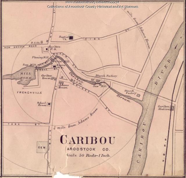
Contributed by: Aroostook County Historical and Art Museum Date: circa 1870 Location: Caribou Media: Ink on paper
Item 108835

Plan of lots 1-10, Fairfield, 1782
Contributed by: Maine Historical Society Date: 1782-12-20 Location: Fairfield Media: Ink on paper
Item 16997

Map of Fryeburg Village in 1878
Contributed by: Fryeburg Historical Society Date: circa 1878 Location: Fryeburg Media: Map
Item 18722

Modern rendering of John Small's map of Falmouth, 1753
Contributed by: Maine Historical Society Date: 1753 Location: Falmouth Media: Map, ink on paper
Item 31237

Moses Banks Map, Scarborough, 1787
Contributed by: Scarborough Historical Society & Museum Date: 1787 Location: Scarborough Media: Paper and ink
Item 11827
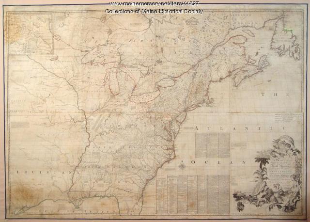
Map of the British and French North America, 1775
Contributed by: Maine Historical Society Date: 1755 Media: Ink on paper, map
Item 11826

Moses Greenleaf's map of the District of Maine, 1815
Contributed by: Maine Historical Society Date: 1815 Media: Ink on paper, map
Item 23341

Map of Cushing Island, ca. 1888
Contributed by: Maine Historical Society Date: circa 1888 Location: Portland Media: Ink on paper, map
Item 11836

Map of Passamoquoddy Bay, 1925
Contributed by: Maine Historical Society Date: 1925 Media: Ink on paper, map
Item 105272

"Map of Portland and some places thereabout," 1928
Contributed by: Osher Map Library and Smith Center for Cartographic Education Date: 1928 Location: Portland Media: Lithograph
Item 11784

Map of the Inhabited Part of Maine, Moses Greenleaf, 1829
Contributed by: Maine Historical Society Date: 1778 Media: Ink on paper, map
Item 17573

Lumbermen and Sportsmen's Map, 1894
Contributed by: Maine Historical Society Date: 1894 Media: Ink on paper, map
Item 100725

Contributed by: Maine Historical Society Date: 1858 Location: Portland Media: Lithograph with hand-coloring
Item 31520

Locating the old houses of Cumberland map, by Hope Dilloway, 1989
Contributed by: Prince Memorial Library Date: circa 1871 Location: Cumberland Media: Ink and watercolor on paper
Item 108837

Copy of Thomas Johnston's Plan of part of the Eastern Shore, ca. 1770
Contributed by: Maine Historical Society Date: 1753 Media: Ink on paper
Item 10832

Map by Francis Joseph Neptune, Cobscook River, 1798
Contributed by: Maine Historical Society Date: 1798 Media: Ink on paper
Item 7494

Map of New England and New York, ca. 1676
Contributed by: Maine Historical Society Date: circa 1676 Media: Ink on paper
Item 22489

Northern Maine boundary map, 1843
Contributed by: Maine Historical Society Date: 1843 Media: Ink on paper, map
Item 34148

Black Point, Scarborough, ca. 1741
Contributed by: Scarborough Historical Society & Museum Date: circa 1741 Location: Scarborough Media: Paper on cardboard
Item 105630

Contributed by: Maine Historical Society Date: 1835 Media: Ink on paper
Item 11854

Moses Greenleaf's Map of the inhabited part of the state of Maine, 1829
Contributed by: Maine Historical Society Date: 1778 Media: Ink wash on lithograph, Map
Item 23348

Map showing approaches to Mount Desert, 1903
Contributed by: Maine Historical Society Date: 1903 Media: Ink on paper, map
