Category: Nature & Geography, Maps
- Historical Items (576)
- Tax Records (0)
- Architecture & Landscape (0)
- Online Exhibits (6)
- Site Pages (10)
- My Maine Stories (1)
- Lesson Plans (1)
Historical Items
These results include photographs, documents, letters, paintings, artifacts, and many other kinds of Maine related items from collections around the state and elsewhere.
Item 116510

Survey of Lake Huron, West Main Shore, ca. 1820
Contributed by: Maine Historical Society Date: circa 1820 Media: Ink on paper
Item 148307

North Atlantic Appalachian Domain map, 2007
Contributed by: Maine Historical Society Date: 2007 Media: Ink on paper
Item 9600

Cocumgomucsis Lake view to Katahdin, Talcott Survey, 1841
Contributed by: Maine Historical Society Date: 1840 Media: Phototransparency
Item 9601

Cocumgomuc Mountains, Talcott Survey, 1841
Contributed by: Maine Historical Society Date: 1840 Media: Phototransparency
Item 15010

Co-cum-go-muc Mountains, ca. 1841
Contributed by: Maine Historical Society Date: circa 1841 Media: Transparency
Item 15559

Co-cum-go-muc Mountains, ca. 1841
Contributed by: Maine Historical Society Date: circa 1841 Media: Transparency
Item 16540

Map of the Rangeley Lake and Dead River regions, 1885
Contributed by: Maine Historical Society Date: 1885 Media: Ink on paper
Item 16541

Map of lakes of Franklin and Oxford counties, 1876
Contributed by: Maine Historical Society Date: 1876 Media: Ink on paper
Item 17397

Junction of the Du Loup River with the Chaudiere River, ca. 1841
Contributed by: Maine Historical Society Date: circa 1841 Media: Transparency
Item 17398

Sketch of country toward the St. John River, ca. 1841
Contributed by: Maine Historical Society Date: circa 1841 Media: Transparency
Item 17399

Otter Pond, Du Loup Water, 1841
Contributed by: Maine Historical Society Date: 1841-09-20 Media: Transparency
Item 17400

Contributed by: Maine Historical Society Date: 1841-10-20 Media: Transparency
Item 17402

Contributed by: Maine Historical Society Date: 1841 Media: Transparency
Item 17403

Contributed by: Maine Historical Society Date: circa 1841 Media: Transparency
Item 31888

Frederick Rogers to his mother in Bangor, Oct. 11, 1861
Contributed by: Bangor Historical Society Date: 1861-10-11 Location: Bangor Media: Ink on paper
Item 36927

Map of underground routes to Canada, 1898
Contributed by: Maine Historical Society Date: 1780–1865 Media: Ink on paper
Item 59811

Skowhegan, Norridgewock, & Madison electric railway lines, ca. 1928
Contributed by: Seashore Trolley Museum Date: circa 1928 Location: Norridgewock; Skowhegan Media: Ink on paper
Item 105358

The Phillips Road and Trail Map of Baxter State Park, 1972
Contributed by: Osher Map Library and Smith Center for Cartographic Education Date: 1972 Location: Millinocket Media: Lithograph
Item 105441

Machegonne : Portland, also called Falmouth, 1932
Contributed by: Osher Map Library and Smith Center for Cartographic Education Date: 1632–1932 Location: Portland; Falmouth Media: Lithograph
Item 116506

Lake Huron, Part of the Fourth Manitou, ca. 1820
Contributed by: Maine Historical Society Date: circa 1820 Media: Ink on paper
Item 22215
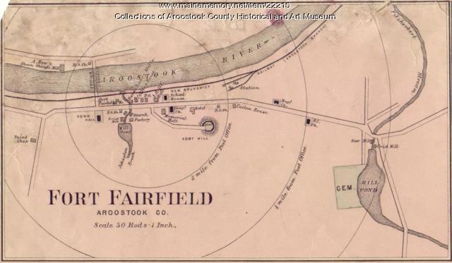
Map of Fort Fairfield, ca. 1870
Contributed by: Aroostook County Historical and Art Museum Date: circa 1870 Location: Fort Fairfield Media: Ink on paper
Item 4181

Contributed by: Maine Historical Society Date: 1874 Media: Paper
Item 6848

Contributed by: Maine Historical Society Date: circa 1840 Location: Westbrook Media: Ink on paper
Item 22212

Contributed by: Aroostook County Historical and Art Museum Date: circa 1870 Location: Houlton Media: Ink on paper
