Keywords: Early maps
- Historical Items (263)
- Tax Records (0)
- Architecture & Landscape (0)
- Online Exhibits (29)
- Site Pages (128)
- My Maine Stories (7)
- Lesson Plans (0)
Site Pages
These sites were created for each contributing partner or as part of collaborative community projects through Maine Memory. Learn about collaborative projects on MMN.
Site Page

"Wabanaki Agency in the Proprietor Records Acknowledgement In the twenty-first century, historians and tribal scholars have turned to these…"
Site Page

"Wabanaki Agency in the Proprietor Records Kinship and Leadership Copy, deed from James and Rachell Berry to Proprietors, page 1 of 3Maine…"
Site Page

"Wabanaki Agency in the Proprietor Records Essay by Lisa Brooks (Abenaki), Fall 2022 Lisa Brooks (Missisquoi Abenaki) Henry S."
Site Page

"Wabanaki Agency in the Proprietor Records Sovereignty and Subsistence Copy, account regarding deed from Abenaki Sagamores to Richard Wharton…"
Site Page

"Beyond Borders: A Wabanaki Perspective Past meets Present I am particularly struck by how similar the Proprietors’ documents and actions feel to…"
Site Page

"Beyond Borders: A Wabanaki Perspective Darren J. Ranco, PhD (Penobscot), Fall 2022 The collections in the Beyond Borders project are important and…"
Site Page

"The Shaping of the Borderlands: Arcane Deeds and Failed Colonies Boundary between United States and New Brunswick, undatedMaine Historical…"
Site Page

Thomaston: The Town that Went to Sea - Early Shipbuilders - 1780s
"… Early Shipbuilders - 1780s Map of the Georges River, Thomaston, Maine 2009Thomaston Historical Society By the time Thomaston was…"
Site Page

Maine's Road to Statehood - Maine in the 17th Century
"Maine in the 17th Century Map of New England and New York, ca. 1676 Largely an unexplored territory by European settlers, 17th century Maine…"
Site Page

Maine's Road to Statehood - Overview: Road to Statehood
"Header image, detail of A Map of the State of Maine (1820) by Moses Greenleaf. Contributed by Osher Map Library and Smith Center for Cartographic…"
Site Page

Islesboro--An Island in Penobscot Bay - Early Settlements
"Early Settlements map of Islesboro Text by Lang Smith Big Tree, Islesboro, ca. 1920Islesboro Historical Society Islesboro was first settled…"
Site Page

Blue Hill, Maine - Shipbuilding: An Important Early Industry
"The settlement was not on the map at first because the British had found long straight trees that were good for building masts, so the map makers did…"
Site Page

Maine's Road to Statehood - The Missouri Compromise: A Moral Dilemma
"Map of the State of Maine, 1820Osher Map Library and Smith Center for Cartographic Education Within the United States, a greater sectional debate…"
Site Page

Maine's Road to Statehood - 1790s: A Growing Movement
"… effort soon died out.[16] District of Maine map, 1795 Drawn in 1795, this map promoted the separation of Maine from Massachusetts."
Site Page

Thomaston: The Town that Went to Sea - Early Wharves and Yards - 1795 to 1825
"Map of the Georges River, Thomaston, Maine 2009Thomaston Historical Society Early in the century, boat builders built coastal schooners and barges…"
Site Page

Thomaston: The Town that Went to Sea - Early History - 1719 to 1740
"Map of Lincoln, Thomaston, Maine in 1719Thomaston Historical Society Throughout Lovewell’s War, 1721-1726, the Indians and their French allies again…"
Site Page

"Champlain’s early map gives this island the name “Brule-Cote,” meaning “Burnt-hill” in his native French, presumably due to evidence of past fires on…"
Site Page

Farmington: Franklin County's Shiretown - Index
"… Commerce & the Railroad - Agriculture, Places Maps - Main Page Measuring Rock - Brief History, Places Meeting House Park - Places North Church -…"
Site Page

Farmington: Franklin County's Shiretown - The Brick Inn
"… has been noted on this 1861 Walling Topographical Map of the Franklin County with Town of Farmington noted (map from Library of Congress)."
Site Page
Farmington: Franklin County's Shiretown - Brief History
"… Library, and Maine Historical Society 1794 map of FarmingtonFarmington Historical Society "Farmington is undoubtly one of the best…"
Site Page

Farmington: Franklin County's Shiretown - Agriculture
"Regional History Reprints. Originally published in 1846. Franklin Chronicle Newspapers. 1840-1918. Various magazine articles and maps."
Site Page
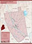
Farmington: Franklin County's Shiretown - Education
"Education Click the icon to see a map of the early schools of Farmington. X By Nancy Porter, Researcher and Page Creator With images from…"
Site Page

Maine's Road to Statehood - Turn of the Century to the War of 1812
"… and would continue to play a major role in early statehood as Mane's first governor. Patten Free Library The separationists and…"
Site Page

Farmington: Franklin County's Shiretown - Hotel Willows, Farmington, ca. 1910
"… A photographic image on heavy paper was used as early advertising or as a postcard. This shows the Hotel Willows in landscaped setting, and…"
