Keywords: trail maps
Item 148307

North Atlantic Appalachian Domain map, 2007
Contributed by: Maine Historical Society Date: 2007 Media: Ink on paper
Item 11285

Map of the Conquest of Katahdin, 1933
Contributed by: Baxter State Park Date: 1934 Location: Mt. Katahdin Twp. Media: Ink on paper, Photographic print

Item 149097

New York Botanical Garden Ornamental Conifer Collections, Bronx, NY, 1946-1999
Contributed by: Maine Historical Society Date: 1946–1999 Location: Bronx Client: New York Botanical Gardens Architect: Patrick Chasse; Landscape Design Associates
Item 149072

Frank residence master bedroom planting plan, Lincoln, MA, 1964-2002
Contributed by: Maine Historical Society Date: 1964–2002 Location: Lincoln Clients: Bob Frank; Velma Frank Architect: Patrick Chasse; Landscape Design Associates

Exhibit
Building the International Appalachian Trail
Wildlife biologist Richard Anderson first proposed the International Appalachian Trail (IAT) in 1993. The IAT is a long-distance hiking trail along the modern-day Appalachian, Caledonian, and Atlas Mountain ranges, geological descendants of the ancient Central Pangean Mountains. Today, the IAT stretches from the Katahdin Woods and Waters National Monument in Maine, through portions of Canada, Greenland, Iceland, the Faroe Islands, and Europe, and into northern Africa.
Exhibit

The boundaries of Maine are the product of international conflict, economic competition, political fights, and contested development. The boundaries are expressions of human values; people determined the shape of Maine.

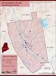
Site Page

Farmington: Franklin County's Shiretown - Maps
"All the other maps were built on the base map. Farmington Base Map Farmington Agricultural Sites Farmington Cemeteries Farmington Cultural Interest…"
Site Page
Farmington: Franklin County's Shiretown - Early Settlers
"… or horse through unsettled areas following the trails of early trappers or Indians. Some of the men who came to Farmington prior to 1800 and who…"
Story

Tracers
by anonymous
tracers, bonding, and fixations
