
(Page 7 of 8) Print Version
Clean water, warming water
Warming Oceans
by David Reidmiller Ph.D. Director, Climate Center Gulf of Maine Research Institute

The Gulf of Maine is experiencing physical, chemical, and biological changes as a result of climate change. The unprecedented accumulation of greenhouse gasses in the atmosphere over the past century traps excess heat in the Earth system, with world oceans absorbing more than 90%.
As a result of its shape, bathymetry (the measurement of depth of water), and changes in large-scale ocean currents like the Gulf Stream, the rate of warming in the Gulf of Maine is faster than that of more than 95% of the world’s oceans. At the surface, this additional heat can impede vertical mixing of ocean water, preventing life-sustaining nutrients from reaching organisms closer to the surface. Throughout the water column, warming waters create a friendlier environment for certain fish species and pathogens that can disrupt ecosystems, causing population declines and shifts.
Oceans provide us with an “ecosystem service” because they absorb carbon dioxide (CO2)—the primary greenhouse gas—from the atmosphere as a natural part of Earth’s carbon cycle. But the unnatural pace that humanity is emitting CO2 into the atmosphere is causing an increase in CO2 absorption by the world’s oceans, resulting in a gradual acidification of seawater—a 30% increase in acidity since pre-industrial times. More acidic water makes it more difficult for shellfish like lobsters, oysters, and clams to form their exoskeleton or shells. These changes present risks to coastal communities who rely on the ocean for their livelihoods and well-being.
But changes offer opportunities to create new markets for emergent species and adapt business practices to the continually changing marine environment as a result of climate change. In the process, Maine’s marine-dependent communities can serve as a global model for adapting and thriving in a warmer world.
The Penobscot River

Penobscot Tribal petitions about encroachment and timber industry, Stockton Springs, 1772
Item Contributed by
Maine Historical Society

The Penobscot River is New England’s largest river system, draining an area of 8,570 square miles.
Maine’s northern climate and geography, a landscape shaped by cool temperatures and receding glaciers, created an environment of dense mixed hardwood and conifer trees. Paper companies like Great Northern Paper industrialized the Maine woods. They took over millions of acres of forestlands, and dammed rivers to transport logs and generate power. Companies eventually controlled waterways, dumping industrial effluent freely into the rivers and air.
The use of Petitions to communicate displeasure or critique of colonial authorities by Wabanaki Nations is a long standing tradition, stretching back to the 17th century. Petitions reflected Wabanaki diplomatic traditions, that understands documents like treaties as relational agreements, dependent on consistent communication and understanding to hold meaning. They also served to inform Colonial authorities of conditions on the ground, where individual settlers would often break the agreements made by the Colonial authorities with Wabanaki Tribal Nations, and would sometimes forcefully correct or punish these individual settlers violating the treaties or agreements.

James E. Francis kapahse (sturgeon) drum, Indian Island, 2019
Item Contributed by
Maine Historical Society

Settler industrialists saw Maine as a resource-rich landscape with unending supplies of trees, granite, animals, and fish. There were approximately 119 dams constructed to support the lumber and paper industries on the Penobscot River that blocked fish migrations and other animals from using the water.
Mills also polluted the water, compromising the animals and humans living along the rivers. Starting in 2004, The Penobscot River Restoration Project opened up 2,000 miles of rivers and streams to sea-run fish through dam removals and fish passageways, while increasing hydropower generation.
Settlement, logging operations, mills, and dams have obstructed the passage of fish like sturgeon, salmon, and shad that migrate up the Penobscot River from the ocean to spawn.
According to the International Union for Conservation of Nature (IUCN), as of 2023, 100% of the 26 species of surviving sturgeon are now at risk of extinction due to dams and poaching, up from 85% in 2009.
Penobscot oral histories include stories about human obligations to fish, but their migrations have been inhibited for over a century. With the removal of dams through the Penobscot River Restoration Project and building effective fish passages, the sturgeon, salmon, and shad are returning, along with language and cultural activities related to the fish. The word kapahse is the Penobscot name for sturgeon.

Protests on the Penobscot River, Bangor, 2018
Courtesy of Chek Wingo/Sunlight Media Collective
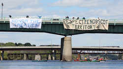
In 2012, Maine State Attorney General William Schneider issued a statement claiming exclusive state control over the Penobscot River. The Penobscot Nation responded to this claim with a lawsuit, attempting to preserve Tribal control over hunting and fishing rights recognized in treaties and the Maine Indians Claims Settlement Act of 1980.
In response, Wabanaki people formed a number of groups in 2014 and 2015 to protect the Penobscot River and educate non-Wabanaki people about the state’s cases. As the lawsuit progressed through the federal court system, Wabanaki citizens engaged in traditional and new forms of public demonstration. This included calling attention to the State of Maine asserting control over the Penobscot River and from the Penobscot Nation.
Penobscot people see the river as a kin relative to which they have never relinquished their rights. While the lawsuit was ultimately decided in favor of the State of Maine, Wabanaki activism raised awareness of ongoing disputes around the extent of Tribal territory and sovereignty, helping build allies and momentum to change unfair and unequal treatment of Wabanaki Nations in state and federal law, as enshrined in the Maine Indian Claims Settlement Act of 1980.
The Androscoggin River

Sketch of Androscoggin River, ca. 1830
Item Contributed by
Edmund S. Muskie Archives and Special Collections Library

Great Falls of the Androscoggin River, Lewiston, ca. 1975
Item Contributed by
Lewiston Public Library
The Androscoggin River, from its source in the Rangeley Lakes to its outlet in Merrymeeting Bay, drops 1,500 vertical feet. During annual fish migrations, Wabanaki people harvested fish like salmon and sturgeon on the falls for millennia, in ways that supported communities and also respected the fish. Later, settler-colonialists built bridges, dams, and mills, which disrupted traditional subsistence activities and caused conflict between Wabanaki peoples and settlers.
Historic paintings show these scenic falls, but also demonstrate the long standing industrial pollution of the Androscoggin for centuries. John A. Briggs built Lewiston’s first cotton mill, in 1836, which burned in 1850.
Mills powered by the Androscoggin River were a driving economic force for centuries. The Cowan Mill, built in 1850 on the footprint of John A. Biggs’ cotton mill, also burned in 2009.
Photographs showing the severe pollution of the Androscoggin River are rare. Local communities surrounding the river before the Clean Water Act likely remember the foul effluent smell and foaming waters, but little photographic evidence survives.

The Clean Water Act of 1972
Maine Senator Edmund “Ed” S. Muskie (1914-1996) ushered The Clean Water Act of 1972 through Congress to ensure Americans’ access to drinkable, swimmable and fishable water. In 1972, clean air and water was not a given, and Maine’s Androscoggin River was listed as one of the top 10 polluted rivers in the nation.
Acknowledging water’s essential role for life, the United Nations declared access to clean water and sanitation a basic human right in 2010. Muskie saw laws that protected water as good for Americans, and absolutely necessary for the nation’s survival. He built consensus, and although then President Richard Nixon vetoed the bill, on October 18, 1972, the Clean Water Act became law, with both houses of Congress overriding the veto.
Muskie worked to make the public more aware of the health issues caused by pollution. When campaigning for the 1970 Clean Air Act, Muskie demonstrated his devotion to environmental advocacy saying,
We should all understand that we are all in the same boat. That what happens to our environment must make a difference to all of us, whoever we are. And that what happens to each of us, must make a difference to the rest of us. So we must reclaim the total human environment.
In 2023 America’s water quality in rivers, lakes and streams has improved, but threats to water safety remain. The Act requires the Environmental Protection Agency (EPA)—along with states, Tribes, and territories—to monitor the quality of lakes, rivers, streams, estuaries, and other water bodies. But as of 2017, the EPA’s most recent report, only about half of US waters have been assessed. The Act’s no-discharge goal has yet to be achieved, and in Maine, some freshwater fish are currently contaminated with PFAS (“forever chemicals”), mercury, PCBs, Dioxins, and DDT, making them potentially dangerous to eat.

Water Pollution
Ed Muskie grew up in Rumford near the Androscoggin River, where industries discharged pollutants into the river, and municipalities dumped sewage.
Located on the Androscoggin River in Rumford Falls, the Rumford Sulphite Mill, built in 1895, produced sulphite pulp for paper products. By 1900, Rumford had seven mills including the Rumford Falls Paper Company, the Fort Hill Chemical Company, the Continental Bag Company, the International Paper Company, the Rumford Falls Envelope Factory, and the Oxford Paper Company. Dams on the Androscoggin created a powerful falls known as the “Niagara of New England” providing power to the mills.
A study of the Androscoggin by Dr. Walter Lawrance, a Bates College chemistry professor showed that it had almost no dissolved oxygen and therefore could not support fish or aquatic life. The river was threatened not only by industrial chemicals, but also by organic debris from log drives and agricultural or sewage runoff.

Summary of river condition, Lewiston, 1948
Item Contributed by
Edmund S. Muskie Archives and Special Collections Library

Student letter to Edmund Muskie, Poland, 1970
Item Contributed by
Edmund S. Muskie Archives and Special Collections Library
From 1943 to 1977, Lawrance produced reports on the condition of the river. The first determined the intensity and cause of the river’s noxious odor in the Lewiston-Auburn area. In the summer of 1948, low river flow and high water temperatures increased the odor. Lawrance noted when paper companies upriver reduced sulphite production, it, “made an appreciable reduction in the pollution load carried by the river.” Lawrence received press coverage, especially for using sodium nitrate to resupply oxygen to the river water.
Suzanne Clune, age 11, wrote to Senator Muskie in 1970 telling him about the Little Androscoggin River, which she said had become quite polluted. She wrote that the river had a “most sickening smell” and that “frogs have been seen gasping for air” and “fish have been seen floating down the river dead.” She stated, “I am sick of the river like this. Please do something about it.”
The EPA requires permits for industries that discharge pollution into water via pipes, but permit holders self-report the levels, sometimes leading to non-compliance.
While point source “pipe” pollution is an important issue, according to the Government Accountability Office, the leading cause of water pollution today is from runoff that carries sediment, oil, bacteria, toxins, and other pollutants from farms, yards, and paved streets and parking lots into nearby waters.

The Scow Vixen loaded with waste for disposal near Ram Island, Portland, 1925
Item Contributed by
Maine Historical Society/MaineToday Media
For centuries, people have used rivers and oceans as dumping grounds, incorrectly believing that water has unending renewable properties.
Starting in 1924, Portland used the scow boat, Vixen, to dispose of city waste in the ocean. They loaded the scow with refuse that could not be carried to the public dump on the shores of Back Bay. A 1925 City manager said moving and disposing garbage into the sea was, “one step more in the direction of ideal sanitary and health conditions.”
Workers loaded The Vixen with up to 100 barrels daily, transporting the waste to dumping grounds off of the eastern end of Ram Island. In 1925, they added a second scow, The Three Brothers, to take care of additional garbage generated in summer months.
The Marine Protection Research and Sanctuaries Act, passed in 1972, the same year as the Clean Water Act, regulates ocean dumping and stopped practices like those of the City of Portland.

Item Contributed by
Edmund S. Muskie Archives and Special Collections Library
Richard E. Gosse at the US Public Health Service in Portland wrote to Muskie about the, “wanton disregard by the city of Portland and surrounding communities in the field of pollution.”
Gosse sent Muskie photographs taken from Veranda Street that showed pollution where the Presumpscot River flows into Casco Bay, indicating S.D. Warren Paper Company discharge on the left, flowing near Mackworth Island. Gosse detailed the many pollutants to Muskie, saying,
The smell of this river is nauseating and its contents consists of feces, paper fibers, etc. The photos I think illustrate how the current of the Presumpscot River carries this filth out into Casco Bay.
Gosse was one of hundreds of people who wrote to Muskie, expressing their concerns and helping to strengthen his case that the federal government must do something to protect the environment.


The Pejepscot Paper Company Mill on the Androscoggin River in Topsham was flooded on March 20, 1936. Because of climate change, increased and severe weather events are causing even more flooding as of 2023, leading water and wastewater infrastructure to fail, leaving people without water and contaminating surrounding areas.
Creativity and making small scale solutions to bolster the natural world are strategies for combating climate change. Harpswell-based Margaret Leonard paints abstracted landscapes that show the human condition and the traces of human existence in the environment. In 2022, she began a series based upon the Frank J. Wood Bridge that spans Brunswick and Topsham over the Androscoggin River, because it is slated for removal.

"January Androscoggin Study Winter Tree Play," by Veronica Benning, 1987
Item Contributed by
Maine Historical Society
Leonard’s Bridge series paintings demonstrate a lively river with jumping sturgeon and people fishing, a common occurrence in 2023. However, despite progress, the Androscoggin continues to be contaminated and polluted. The Maine Division of Environmental and Community Health recommends people fishing on the Androscoggin eat, “No more than 6-12 fish meals a year of any fish species.”
Art can document and be a bridge between the facts of climate change, and the emotions we feel about it. Abstract painter Veronica Benning taught at Portland School of Art, later the Maine College of Art, and became fascinated with Maine landscapes saying she found that, “Maine’s natural beauty became a foundation of learning ‘to see’ in terms of painting.”
The Clean Water Act of 1972’s goals required zero pollution by 1985. When Benning created this painting in 1987, the Androscoggin was still actively polluted, yet she found a way to be inspired by the coldness of January and the beauty of the trees and water.
Friendly URL: https://www.mainememory.net/exhibits/CODERED
