Contributed by Islesboro Historical Society

Description
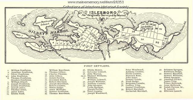
This map shows the plots of land owned by the first settlers of Islesboro. It was originally drawn up in 1799 by Samuel Warren, Jr., himself a settler on Islesboro, to settle a dispute with General Henry Knox over ownership of the island. Islesboro lies north to south, rather than east to west as this map indicates.
Transcription
About This Item
- Title: Warren Survey Map, Islesboro, ca. 1893
- Creator: Samuel Warren, Jr.
- Creation Date: circa 1893
- Subject Date: circa 1799
- Location: Islesboro, Waldo County, ME
- Media: Ink on paper
- Local Code: 97.01
- Object Type: Text and Image
Cross Reference Searches
Standardized Subject Headings
People
Other Keywords
For more information about this item, contact:
Islesboro Historical SocietyPO Box 301, 388 Main Road, Islesboro, ME 04848
(207) 734-6733
Use of this Item is not restricted by copyright and/or related rights, but the holding organization is contractually obligated to limit use. For more information, please contact the contributing organization. However, watermarked Maine Memory Network images may be used for educational purposes.
Please post your comment below to share with others. If you'd like to privately share a comment or correction with MMN staff, please send us a message with this link.
