

North Atlantic Appalachian Domain map, 2007
Item 148307 info
Maine Historical Society
Bill Duffy, cartographer for the International Appalachian Trail (IAT), created this map to highlight the modern ranges once part of the Central Pangean Mountains over 300 million years ago. Today, the mountains in these areas are some of the oldest on earth and bear geographic and fossil evidence of their common origin. It is through these regions that the IAT passes.

IAT annual general meeting, Maine Chapter, Shin Pond, 2006
Item 148293 info
Maine Historical Society
Volunteers from Maine and Canada gathered to plan the IAT in the spring of 1994. In the months that followed, they established organizational chapters in Maine, New Brunswick, and Québec. Collectively, the chapters referred to themselves as the International Appalachian Trail/Sentier International des Appalaches, or IAT/SIA.
Each year, the chapters and the International Council of the IAT hold general meetings. In 2006, members of the Maine Chapter held their annual meeting at Shin Pond, near Katahdin.
The IAT relies on volunteer hours and commitment. Over the years, Maine Chapter members have gradually shifted the state’s trail from roads to forested areas, built a library of hiker resources, and maintained campsites and portions of trail.

Richard Anderson, Cap Gaspé, Canada, 1999
Item 110872 info
Maine Historical Society
Richard Anderson, a founder of the IAT, attended the trail’s official dedication at Cap Gaspé, Québec, Canada in 1999.

International Appalachian Trail/Sentier International des Appalaches Day proclamation, 1999
Item 148294 info
Maine Historical Society
In recognition of the completion of the IAT from Maine to Québec, then Maine Governor Angus S. King, Jr., declared June 5, 1999, International Appalachian Trail/Sentier International des Appalaches Day.
IAT members in Maine and SIA members in Canada collaborated to develop the trail. Governor King acknowledged this cooperation in the proclamation, declaring the venture a “joining of partners,” and noting the trail’s crossing of political and linguistic borders to “link two nations and several cultures within a single bioregion.”

Richard Anderson IAT Maine Chapter membership card, 1998
Item 148296 info
Maine Historical Society
Richard Anderson is both a member and the first president of the Maine Chapter of the IAT. As a non-profit, IAT’s members provide crucial financial and logistical support to the organization and its mission.
Each chapter’s board, elected by members, spearheads projects to care for and develop the route in their region such as cutting trails, cleaning campsites, securing insurance policies, and working with legislators and journalists.

Wendell and Marie Pierce sign land use agreement with Richard Anderson, Mars Hill, 1995
Item 148297 info
Maine Historical Society
Establishing a new long-distance hiking trail presented multiple obstacles, including the swaths of private land between the Katahdin Woods and Waters National Monument and the US-Canada border. Members routed the IAT primarily through public lands, getting permissions from local and state governments, but it was impossible for the IAT to entirely avoid passing through private property.
Anderson drew up land use agreements with property owners such as Marie and Wendell Pierce, owners of much of Mars Hill Mountain where the IAT built the trail’s first lean-to campsite in Maine.

Maine IAT map, 2008
Item 148298 info
Maine Historical Society
In his 2019 article, “Beyond Borders: The Story of the International Appalachian Trail,” Don Hudson, co-founder of the IAT, described the trail’s evolution since 2001:
"Almost 90 percent of the trail in Maine was set along the shoulder of country roads. Eighteen years later, the IAT in Maine...follows a combination of single-track trails in the woods, old forestry roads, a stretch of repurposed railway bed between Houlton and Bridgewater and about 15 miles of the international border between Mars Hill and the border crossing at Fort Fairfield. Only about 15 percent of the trail is located on country roads and plans are afoot to decrease the number of road miles to as few as 10 over the 130-mile distance."

Building an IAT lean-to, Grand Pitch, 2005
Item 148300 info
Maine Historical Society
In addition to routing, marking, mapping, and publicizing the trail, IAT members and volunteers established campsites along the route. Select sites feature wooden lean-tos, like those found along the original Appalachian Trail.
Crews of volunteers built the lean-tos, using designs by IAT cartographer Clarence “Charlie” Gilman. Volunteers continue to manage, repair, and clean IAT lean-tos and campsites.
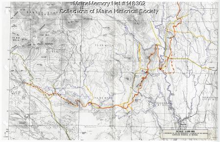
IAT route map, 1995
Item 148302 info
Maine Historical Society
Clarence “Charlie” Gilman, a retired Naval commander and cartographer with the US Geological Survey, sketched many maps and routes for the IAT’s initial path through Maine. Various portions of Gilman’s early trail maps included alternate routes, sometimes accompanied by notes explaining factors favoring one proposal or another.
This map was part of a larger report Gilman drafted about routing, cutting, and marking the IAT through Maine’s upper Penobscot County, accompanied by information about the area’s vegetation and infrastructure.

Resolution concerning the International Appalachian Trail, 2008
Item 148303 info
Maine Historical Society
At the 32nd conference of the New England Governors and the Eastern Canadian Premiers in 2008, American and Canadian leaders signed a resolution affirming ongoing support for the transnational trail.
The resolution officially recognized the IAT’s role physically and culturally connecting neighboring regions and serving as a celebration of shared geology

Rules of the trail, IAT/SIA newsletter, 1995
Item 148304 info
Maine Historical Society
The IAT functions as a collective of independent chapters. Each participating authority, whether a state, province, territory, or nation, has its own chapter that oversees the development and management of its portion of trail.
While some chapters neighbor one another and coordinate closely, such as those of Maine and Maritime Canada, all chapters cohere around principles, trail signage, and a shared vision of the IAT.

Port aux Basques trail opening, Newfoundland, Canada, 2003
Item 148305 info
Maine Historical Society
IAT volunteers expanded the trail in stages, with each new portion celebrated as a local and collective achievement. At the opening of the initial stretch of trail in Newfoundland, long-time members, including Richard Anderson and M.J. Eberhart, joined with regional chapter members to commemorate the event.

Kelly’s Bridge, border of Northern Ireland and the Republic of Ireland, 2016
Item 148306 info
Maine Historical Society
In 2013, the IAT established a trail through Northern Ireland and the Republic of Ireland. Called the Ulster-Ireland Trail, it joined two nations with a history of conflict. Former Maine Senator and Special Envoy for Northern Ireland, George J. Mitchell, deemed it a “spectacular and historic section of trail.”
This slideshow contains 13 items
