(Page 1 of 6) Print Version


Holding up the Sky was curated and advised by:
Lisa Brooks (Abenaki) Professor of English and American Studies, Amherst College, Massachusetts; James Eric Francis Sr. (Penobscot) Director of Cultural and Historic Preservation, Penobscot Nation; Suzanne Greenlaw (Maliseet) Ph.D student, University of Maine, Orono; Tilly Laskey, Curator, Maine Historical Society; Micah Pawling, Professor of History and Native American Studies, University of Maine, Orono; Darren Ranco (Penobscot), Professor of Anthropology and Coordinator of Native American Research, University of Maine, Orono; Theresa Secord (Penobscot), Artist and Maine Historical Society Trustee; Ashley Smith (Wabanaki descent), Assistant Professor of Native American Studies and Environmental Justice, Hampshire College, Massachusetts; Donald Soctomah (Passamaquoddy) Director, Passamaquoddy Cultural Heritage Center and Passamaquoddy Tribal Historic Preservation Officer.
On display at Maine Historical Society, 489 Congress Street, Portland, Maine from April 12, 2019-February 1, 2020
Please visit State of Mind: Becoming Maine, a companion exhibition examining Maine's Bicentennial.
What does it mean to be in one place for over 13,000 years?
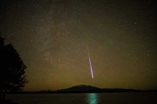
Katahdin by James Eric Francis Sr. (Penobscot)
According to Penobscot oral histories, Glooscap, the first man, keeps his lodge at Katahdin, called ktàtən in the Penobscot language. The mountain is an important and sacred place. At 5,270 feet above sea level, Katahdin is the highest point in Maine. James Eric Francis took this image on November 15, 2014 during an aurora borealis and meteor shower event. Courtesy of the artist.
Wabanaki means People of the Dawnland. As the first people to greet the sunrise, they are responsible for “holding up the sky.”

Map by Steve Bicknell, Courtesy of the Anthropology Department, University of Maine, Orono
Wabanaki people, including the Maliseet, Micmac, Passamaquoddy, Penobscot, and Abenaki Nations, have inhabited what is now northern New England, the Canadian Maritimes, and Quebec, since time immemorial according to oral histories, and for at least 13,000 years according to the archaeological record.
Wabanakis are constantly adapting in response to dramatic changes in the environment. Their cultures also have changed over time, with the development of sophisticated political networks, evolving philosophies, and a deep understanding of the landscape.
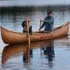
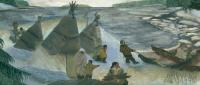
For generations, Wabanaki people traveled seasonally, planting corn on the riverbanks in the spring, harvesting fish on the coast and gathering berries during the summer, and hunting game in the woods during wintertime. Their mobile lifestyle was prosperous, but radically changed with the coming of European settlers around 400 years ago, and later with the splitting of ancestral territory through the establishment of arbitrary international and state borders.
Archaeology
Glaciers covered Maine 15,000 years ago. As the climate warmed a tundra landscape and large game evolved, including wooly mammoths, mastodons, and saber-toothed cats. Between 9,000 and as many as 13,000 years ago, Paleo Indians—ancestors of the Wabanaki— followed the big game, hunting and living in what is now Maine.
Rivers developed from melting glaciers and forests grew as the environment stabilized. The Wabanaki adapted to the changing ecosystem, becoming expert stone and toolmakers, weaving baskets and snowshoes, and creating other cultural items that enabled successful hunting and fishing. Lifestyles were mobile, and people traveled and traded over long distances.
Kineo Rhyolite


Mount Kineo is located on Moosehead Lake. The mountain contains one of the largest formations of rhyolite (igneous rock that is the volcanic equivalent of granite) in the world. The Kineo Rhyolite is prized for being an extremely strong and durable stone, yet easily carved. For this reason, it was ideal for making projectile points and other tools.
Wabanaki oral histories re-count stories of Gluscabe, who created Mount Kineo by making an arrowhead out of a nearby stone and shooting it at a cow moose. The moose fell, and turned into that specific stone—Kineo Rhyolite—that is quarried at Mount Kineo and is the perfect tool for making projectile points.
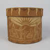
When the inland sea covering Maine receded, it left a thick layer of marine clay—the Presumpscot Formation—perfect for forming pottery vessels. As populations grew, so did technology. Pottery making in Wabanaki communities began around 3000 years ago, making storing and cooking food much easier. This pot dates to about 2700 years ago and was found at Harlow's Point along the shoreline of Lake Auburn in 1881.
Friendly URL: https://www.mainememory.net/exhibits/holdingupthesky
Explore historic and contemporary histories by Wabanaki people