LC Subject Heading: United States--Boundaries--Canada
- Historical Items (138)
- Tax Records (0)
- Architecture & Landscape (0)
- Online Exhibits (0)
- Site Pages (0)
- My Maine Stories (0)
- Lesson Plans (0)
Historical Items
These results include photographs, documents, letters, paintings, artifacts, and many other kinds of Maine related items from collections around the state and elsewhere.
Item 10123

Webster-Ashburton anniversary proclamation, 1992
Contributed by: Fort Kent Historical Society Date: 1842-08-08 Location: Fort Kent Media: Ink on paper
Item 10124

Treaty anniversary proclamation, 1992
Contributed by: Fort Kent Historical Society Date: 1842-08-09 Media: Ink on paper
Item 10125

New Brunswick Treaty of Washington anniversary proclamation, 1992
Contributed by: Fort Kent Historical Society Date: 1842-08-09 Media: Ink on paper
Item 11786

Contested Northeast boundary map, 1843
Contributed by: Maine Historical Society Date: 1843 Media: Ink on paper
Item 11833

Index Map of International Boundary, 1930
Contributed by: Maine Historical Society Date: 1930 Media: Ink on paper, map
Item 11834

Map showing Monument and Glendenning Brooks, 1924
Contributed by: Maine Historical Society Date: 1924 Media: Ink on paper, map
Item 11836

Map of Passamoquoddy Bay, 1925
Contributed by: Maine Historical Society Date: 1925 Media: Ink on paper, map
Item 11985

James Irish Letter to Samuel Cook, June 12, 1826
Contributed by: Cary Library Date: 1826 Location: Houlton; Houlton; Fredericton Media: Ink on paper
Item 15787

Contributed by: Bangor Public Library Date: 1944 Location: Calais; St. Stephen Media: Photographic print
Item 20763

Penobscot River and Chesuncook Lake, 1820
Contributed by: Maine Historical Society Date: 1820 Media: Ink on paper
Item 20814

Jarvis letter concerning Maine boundaries, 1832
Contributed by: Maine Historical Society Date: 1832 Media: Ink on paper
Item 28423

John Quincy Adams instruction on northeast boundary, 1823
Contributed by: Maine Historical Society Date: 1823 Media: Ink on paper
Item 31460

Contributed by: Penobscot Marine Museum Date: 1911 Location: Fort Kent Media: Glass Negative
Item 33468

Customs Office, Lubec, ca. 1963, ca. 1963
Contributed by: Lubec Historical Society Date: circa 1963 Location: Lubec Media: Photo transparency
Item 36237
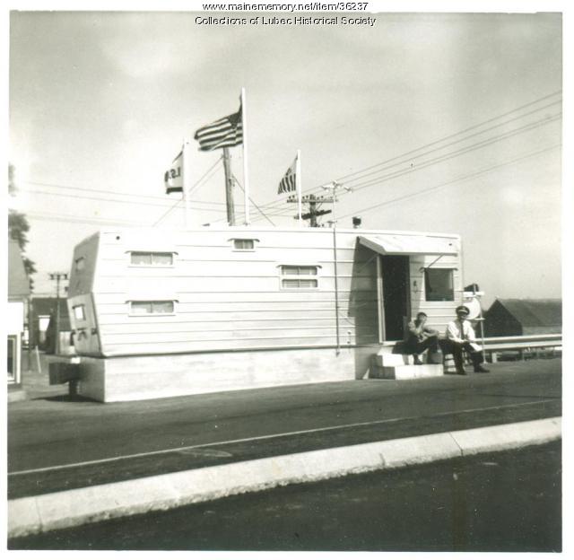
Customs office, Lubec, 1963, 1963
Contributed by: Lubec Historical Society Date: 1963 Location: Lubec Media: Photographic print
Item 36261

Ebeneezer Greely letter from jail, New Brunswick, 1837
Contributed by: Maine Historical Society Date: 1837 Location: Madawaska; Fredericton Media: Ink on paper
Item 105351

"Plan of the British and American positions, on the disputed territory by an eye witness," 1843
Contributed by: Osher Map Library and Smith Center for Cartographic Education Date: circa 1838 Media: Lithograph
Item 110911

North Branch of the Meduxnekeag River, ca. 1817
Contributed by: Maine Historical Society Date: circa 1817 Media: Ink on paper
Item 110913

"Part of Bug Island" map fragment, ca. 1823
Contributed by: Maine Historical Society Date: circa 1823 Media: Ink on paper
Item 110936

Map of Campobello Island, ca. 1840
Contributed by: Maine Historical Society Date: circa 1840 Location: Campobello Island Media: Ink on paper
Item 110988

Contributed by: Maine Historical Society Date: circa 1820 Media: Ink on paper
Item 111019

A plane chart of Koochechee Seepe, called Rainy River, ca. 1820
Contributed by: Maine Historical Society Date: circa 1820 Media: Ink on paper
Item 111036

Contributed by: Maine Historical Society Date: circa 1820 Media: Ink on paper
Item 116491

Manuscript map of Lake Superior to Lake of the Woods, ca. 1822
Contributed by: Maine Historical Society Date: circa 1820 Media: Ink on paper
