LC Subject Heading: Plymouth Company (1749-1816)--Records and correspondence--Maps
- Historical Items (38)
- Tax Records (0)
- Architecture & Landscape (0)
- Online Exhibits (0)
- Site Pages (0)
- My Maine Stories (0)
- Lesson Plans (0)
Historical Items
These results include photographs, documents, letters, paintings, artifacts, and many other kinds of Maine related items from collections around the state and elsewhere.
Item 12558

Contributed by: Maine Historical Society Date: circa 1800 Location: Skowhegan Media: Ink on paper
Item 12571

Contributed by: Maine Historical Society Date: 1810-06-15 Location: Windsor; Windsor Media: Ink on paper
Item 12560

Plan of lots on Sheepscot Pond, Palermo, 1806
Contributed by: Maine Historical Society Date: 1806-06-27 Location: Palermo Media: Ink on paper
Item 12563

Survey of settlers' lots in Norridgewock, 1802 and 1803
Contributed by: Maine Historical Society Date: 1803 Location: Norridgewock; Norridgewock Media: Ink on paper
Item 12197
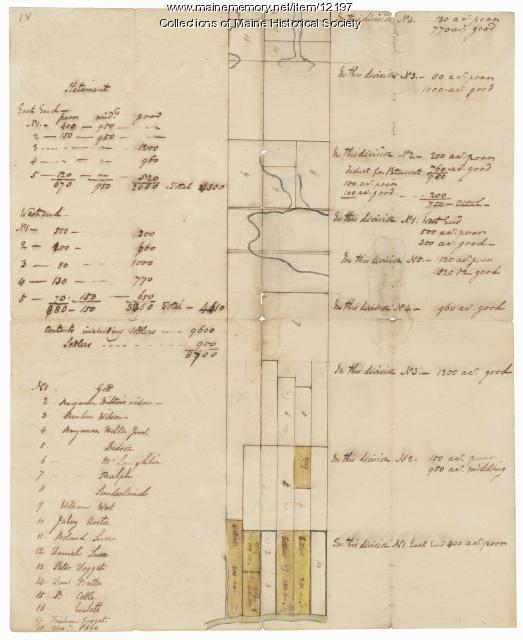
Division of the Tyng and Lowell estates, ca. 1760
Contributed by: Maine Historical Society Date: circa 1760 Media: Ink on paper
Item 12199

Plan of Cathance River, Bowdoinham, ca. 1740
Contributed by: Maine Historical Society Date: circa 1740 Location: Bowdoinham Media: Ink on paper
Item 12380

Tract granted to Samuel Goodwin, ca. 1757
Contributed by: Maine Historical Society Date: circa 1757 Location: Dresden Media: Ink on paper
Item 12381

Lot No. 39 of the Plymouth Company grant, June 1764
Contributed by: Maine Historical Society Date: 1764-06-27 Location: Winslow Media: Ink on paper
Item 12395

Map of Wesserunsett stream, 1790
Contributed by: Maine Historical Society Date: 1790-12-12 Location: Canaan; Canaan Media: Ink on paper
Item 12398

Early map of the Sheepscot River, 1816
Contributed by: Maine Historical Society Date: 1816-01-08 Location: Somerville; Whitefield; Windsor Media: Ink on paper
Item 12851

Contributed by: Maine Historical Society Date: 1798 Media: Ink on paper
Item 12852

Kennebec River above Fort Western, ca. 1800
Contributed by: Maine Historical Society Date: circa 1800 Media: Ink on paper
Item 108858

Plan of 200 acres on the Western Side of Kennebec River, Frankfort Plantation, 1758
Contributed by: Maine Historical Society Date: 1758 Location: Dresden Media: Ink on paper
Item 109000

Dresden and Woolwich proposed border, ca. 1757
Contributed by: Maine Historical Society Date: circa 1757 Location: Woolwich; Dresden Media: Ink on paper
Item 110355

Survey of lots, Georgetown, 1793
Contributed by: Maine Historical Society Date: circa 1780 Location: Lubec Media: Ink on paper
Item 11975

Plan of Ruscohegon Alias Parker's Island, Georgetown, 1759
Contributed by: Maine Historical Society Date: 1759-03-22 Location: Georgetown Media: Ink on paper
Item 11976

Plan of the Kennebec River describing the Plymouth patent, ca. 1719
Contributed by: Maine Historical Society Date: circa 1719 Media: Ink on paper
Item 11977

Plan of part of the Eastern Shore, 1753
Contributed by: Maine Historical Society Date: 1753 Media: Ink on paper
Item 12200

Maps of lots on the Androscoggin River, ca. 1760
Contributed by: Maine Historical Society Date: circa 1760 Location: Jay; Canton; Livermore Falls Media: Ink on paper
Item 12202

Plan of Samuel Goodwin's land, Dresden, ca. 1760
Contributed by: Maine Historical Society Date: circa 1760 Location: Woolwich; Dresden; Woolwich; Dresden Media: Ink on paper
Item 12203

Benjamin and Nehemiah Turner's plan containing 200 acres, Palermo, 1806
Contributed by: Maine Historical Society Date: 1806-06-18 Location: Palermo Media: Ink on paper
Item 12382

Plan of Kennebeck River, ca. 1765
Contributed by: Maine Historical Society Date: circa 1765 Media: Ink on paper
Item 12396

Androscoggin River area map, 1771
Contributed by: Maine Historical Society Date: 1771-06-11 Location: Jay; Canton; Livermore Falls Media: Ink on paper
Item 12397

Dr. Silvester Gardiner's tract, Alna, 1761
Contributed by: Maine Historical Society Date: 1759-12-29 Location: Alna Media: Ink on paper
