LC Subject Heading: Maine--History--Colonial period, ca. 1600-1775--Maps, Manuscript
- Historical Items (62)
- Tax Records (0)
- Architecture & Landscape (0)
- Online Exhibits (0)
- Site Pages (0)
- My Maine Stories (0)
- Lesson Plans (0)
Historical Items
These results include photographs, documents, letters, paintings, artifacts, and many other kinds of Maine related items from collections around the state and elsewhere.
Item 5314

Plan of rivers of Saco and Kennebunk, 1731
Contributed by: Maine Historical Society Date: 1731 Media: Ink on paper
Item 12125

Map of Cobbosseecontee Stream, 1765
Contributed by: Maine Historical Society Date: 1765-07-29 Location: Augusta; Gardiner; Farmingdale; Hallowell; Litchfield; Manchester; Winthrop; Monmouth Media: Ink on paper
Item 108831

Contributed by: Maine Historical Society Date: 1774-03-29 Location: Vassalboro Media: Ink on paper
Item 5343

Contributed by: Maine Historical Society Date: 1743 Location: Harpswell Media: Ink on paper
Item 5958

Acter Patten's land, Topsham, 1765
Contributed by: Maine Historical Society Date: 1765-11-09 Location: Topsham Media: Ink on paper
Item 11923

Survey of Robert and John Donlop lots, Brunswick, 1757
Contributed by: Maine Historical Society Date: 1757 Location: Brunswick Media: Ink on paper
Item 11924

Lots on Maquoit Road, Brunswick, 1761
Contributed by: Maine Historical Society Date: 1761 Location: Brunswick Media: Ink on paper
Item 11925

Seven lots on the Androscoggin River, 1771
Contributed by: Maine Historical Society Date: 1771 Location: Brunswick; Topsham; Freeport; Durham Media: Ink on paper
Item 11929
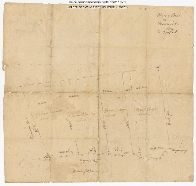
Flying Point at Maquoit Bay, Freeport, ca. 1770
Contributed by: Maine Historical Society Date: circa 1770 Location: Freeport; Brunswick Media: Ink on paper
Item 12196

Map of Kennebec Purchase lots, ca. 1750
Contributed by: Maine Historical Society Date: circa 1750 Media: Ink on paper
Item 22383

Contributed by: Maine Historical Society Date: 1727 Location: North Yarmouth; Falmouth; Freeport Media: Ink on paper
Item 33847

Champlain's map of Saco Bay and the Saco River, 1605
Contributed by: McArthur Public Library Date: 1605 Location: Biddeford; Saco Media: Photographic print
Item 4316

Plan of J. Robinson lot, Topsham, 1761
Contributed by: Maine Historical Society Date: 1761 Location: Topsham Media: Ink on paper
Item 4319

Contributed by: Maine Historical Society Date: circa 1795 Location: Freeport; New Gloucester; Brunswick Media: Ink on paper
Item 4325

"Brunswick in the late Province of Mayne in New England," 1719
Contributed by: Maine Historical Society Date: 1718-01-28 Location: Brunswick Media: Ink on paper
Item 5335

Brunswick and Topsham, ca. 1730
Contributed by: Maine Historical Society Date: circa 1730 Location: Brunswick; Topsham Media: Ink on paper
Item 5956

Estate of William Skinner, Topsham, 1766
Contributed by: Maine Historical Society Date: 1766-06-15 Location: Topsham Media: Ink on paper
Item 5957

William Patten's land, Topsham, 1771
Contributed by: Maine Historical Society Date: 1771-04-12 Location: Bowdoinham Media: Ink on paper
Item 5965

William Patten's land, Topsham, 1770
Contributed by: Maine Historical Society Date: 1770-05-28 Location: Topsham Media: Ink on paper
Item 11727

Cathance Millright's land, Topsham, 1759
Contributed by: Maine Historical Society Date: 1759-06-16 Location: Topsham Media: Ink on paper
Item 11729

Land surveyed for Hugh Wilson, Topsham, 1761
Contributed by: Maine Historical Society Date: 1761-01-01 Location: Topsham Media: Ink on paper
Item 11730

Contributed by: Maine Historical Society Date: 1761-11-12 Location: Topsham Media: Ink on paper
Item 11731

William Patten's lot, Topsham, 1761
Contributed by: Maine Historical Society Date: 1761-11-24 Location: Topsham Media: Ink on paper
Item 11732

Contributed by: Maine Historical Society Date: circa 1760 Location: Topsham Media: Ink on paper
