Keywords: to 1800
- Historical Items (723)
- Tax Records (0)
- Architecture & Landscape (1)
- Online Exhibits (35)
- Site Pages (223)
- My Maine Stories (4)
- Lesson Plans (0)
Historical Items
These results include photographs, documents, letters, paintings, artifacts, and many other kinds of Maine related items from collections around the state and elsewhere.
Item 12561

Lots on Tinkham's Pond, Kennebec Patent, ca. 1800
Contributed by: Maine Historical Society Date: circa 1800 Location: Chelsea; Whitefield Media: Ink on paper
Item 68913

Scarborough landowners, ca. 1800
Contributed by: Maine Historical Society Date: circa 1800 Location: Scarborough Media: Ink on paper
Item 11729

Land surveyed for Hugh Wilson, Topsham, 1761
Contributed by: Maine Historical Society Date: 1761-01-01 Location: Topsham Media: Ink on paper
Item 11732

Contributed by: Maine Historical Society Date: circa 1760 Location: Topsham Media: Ink on paper
Item 11720

Contributed by: Maine Historical Society Date: 1740-09-29 Location: Brunswick Media: Ink on paper
Item 11727

Cathance Millright's land, Topsham, 1759
Contributed by: Maine Historical Society Date: 1759-06-16 Location: Topsham Media: Ink on paper
Item 11725

Contributed by: Maine Historical Society Date: 1772 Location: Brunswick Media: Ink on paper
Item 4319

Contributed by: Maine Historical Society Date: circa 1795 Location: Freeport; New Gloucester; Brunswick Media: Ink on paper
Item 5960

Fort land for William Ross, Brunswick, ca. 1763
Contributed by: Maine Historical Society Date: circa 1763 Location: Brunswick Media: Ink on paper
Item 5320

Peletiah Haly's lot, Haly's Island, ca. 1750
Contributed by: Maine Historical Society Date: circa 1750 Location: Topsham; Brunswick Media: Ink on paper
Item 7950

Islands in Passamaquoddy Bay, ca. 1800
Contributed by: Maine Historical Society Date: circa 1800 Media: Ink on paper
Item 4325

"Brunswick in the late Province of Mayne in New England," 1719
Contributed by: Maine Historical Society Date: 1718-01-28 Location: Brunswick Media: Ink on paper
Item 12852

Kennebec River above Fort Western, ca. 1800
Contributed by: Maine Historical Society Date: circa 1800 Media: Ink on paper
Item 11730

Contributed by: Maine Historical Society Date: 1761-11-12 Location: Topsham Media: Ink on paper
Item 11731

William Patten's lot, Topsham, 1761
Contributed by: Maine Historical Society Date: 1761-11-24 Location: Topsham Media: Ink on paper
Item 11723

Contributed by: Maine Historical Society Date: 1747-07-06 Location: Brunswick Media: Ink on paper
Item 11960

Plan of land on Bramhall Hill by Peleg Wadsworth, ca. 1800
Contributed by: City of Portland Dept. of Public Works Date: circa 1800 Location: Portland Media: Ink and wash on paper, map
Item 108766

Plan of lot no. 1, Lewiston, ca. 1800
Contributed by: Maine Historical Society Date: circa 1800 Location: Lewiston Media: Ink on paper
Item 4323
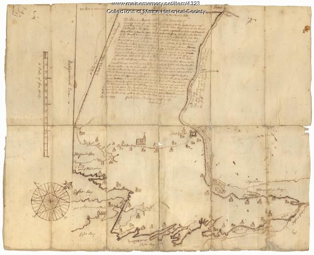
Contributed by: Maine Historical Society Date: 1738 Location: Brunswick; Harpswell; Topsham Media: Ink on paper
Item 4318

Androscoggin River above Lewiston, ca. 1750
Contributed by: Maine Historical Society Date: circa 1750 Location: Turner; Livermore; Wayne; Leeds Media: Ink on paper
Item 108753

Plan of the Bracket Lots, Androscoggin County, ca. 1800
Contributed by: Maine Historical Society Date: circa 1800 Location: Durham Media: Ink on paper
Item 4316

Plan of J. Robinson lot, Topsham, 1761
Contributed by: Maine Historical Society Date: 1761 Location: Topsham Media: Ink on paper
Item 104604

New Map of English America, 1677
Contributed by: Osher Map Library and Smith Center for Cartographic Education Date: 1777 Media: Engraving
Item 104938

"New England the Most Remarqueable Parts Thus Named," 1637
Contributed by: Osher Map Library and Smith Center for Cartographic Education Date: circa 1614 Media: Engraving
