Keywords: map
- Historical Items (939)
- Tax Records (0)
- Architecture & Landscape (209)
- Online Exhibits (33)
- Site Pages (232)
- My Maine Stories (8)
- Lesson Plans (6)
Site Pages
These sites were created for each contributing partner or as part of collaborative community projects through Maine Memory. Learn about collaborative projects on MMN.
Site Page

"Beyond Borders: A Wabanaki Perspective What is not questioned, it seems, in either the 18th century, or the late 20th and early 21st centuries, is…"
Site Page

Maine's Road to Statehood - The Coasting Law of 1789
"… coincide with Maine's separation.[10] New Map of English America, 1677 Since Massachusetts was adjacent to New Hampshire, Connecticut, New…"
Site Page

Maine's Road to Statehood - Overview: Road to Statehood
"Header image, detail of A Map of the State of Maine (1820) by Moses Greenleaf. Contributed by Osher Map Library and Smith Center for Cartographic…"
Site Page

Maine's Road to Statehood - Maine in the 17th Century
"Maine in the 17th Century Map of New England and New York, ca. 1676 Largely an unexplored territory by European settlers, 17th century Maine…"
Site Page

Maine's Road to Statehood - The Missouri Compromise: A Moral Dilemma
"Map of the State of Maine, 1820Osher Map Library and Smith Center for Cartographic Education Within the United States, a greater sectional debate…"
Site Page

Maine's Road to Statehood - 1790s: A Growing Movement
"… effort soon died out.[16] District of Maine map, 1795 Drawn in 1795, this map promoted the separation of Maine from Massachusetts."
Site Page

"Fixing Borders on the Land: The Northeastern Boundary in Treaties and Local Reality, 1763-1842 Moose River, Moose Head Lake and Kennebeck…"
Site Page

"The Shaping of the Borderlands: Arcane Deeds and Failed Colonies Islands in Passamaquoddy Bay, ca."
Site Page

"The Shaping of the Borderlands: Arcane Deeds and Failed Colonies Boundary between United States and New Brunswick, undatedMaine Historical…"
Site Page

Strong, a Mussul Unsquit village - The Bridge That Changed The Map
"The map was changed X But the map had already been changed. In 1861 the legislature had approved the petition of the residents of East Strong."
Site Page

Farmington: Franklin County's Shiretown - Index
"… Commerce & the Railroad - Agriculture, Places Maps - Main Page Measuring Rock - Brief History, Places Meeting House Park - Places North Church -…"
Site Page

Farmington: Franklin County's Shiretown - The Brick Inn
"… has been noted on this 1861 Walling Topographical Map of the Franklin County with Town of Farmington noted (map from Library of Congress)."
Site Page
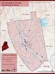
Farmington: Franklin County's Shiretown - Early Settlers
"Early Settlers Click the icon for a map of the locations of early settler's homesteads X By Nancy Porter, Researcher & Page Creator With…"
Site Page
Farmington: Franklin County's Shiretown - Brief History
"… Library, and Maine Historical Society 1794 map of FarmingtonFarmington Historical Society "Farmington is undoubtly one of the best…"
Site Page

Farmington: Franklin County's Shiretown - Agriculture
"Regional History Reprints. Originally published in 1846. Franklin Chronicle Newspapers. 1840-1918. Various magazine articles and maps."
Site Page

Farmington: Franklin County's Shiretown - Education
"Education Click the icon to see a map of the early schools of Farmington. X By Nancy Porter, Researcher and Page Creator With images from…"
Site Page

Maine's Road to Statehood - The American Revolution and Early Attempts at Separation - Page 2 of 2
"The American Revolution and Early Attempts at Separation The committee sent a similar address to the citizens of Maine urging them to support…"
Site Page

Maine's Road to Statehood - The American Revolution and Early Attempts at Separation - Page 1 of 2
"The American Revolution and Early Attempts at Separation Overwhelmingly dedicated to independence from Britain, Mainers quieted any murmurs of…"
Site Page

Maine's Road to Statehood - The Final Vote
"The Final Vote William Williamson to Joseph Williamson on the final vote for separation, Boston, 1819Maine Historical Society For several…"
Site Page

Maine's Road to Statehood - After the War: The First Victory for Separationists
"After the War: The First Victory for Separationists The "Boxer" and "Enterprise," Monhegan, 1831 This painting depicts an 1813 battle between…"
Site Page

Maine's Road to Statehood - Turn of the Century to the War of 1812
"Turn of the Century to the War of 1812 The 1800s welcomed a plethora of economic and demographic changes for the District of Maine."
Site Page
Farmington: Franklin County's Shiretown - Corn Canning Industry
"Corn Canning Industry By 1913, Maine employed 7,000 people in corn factories, one-third of them women."
Site Page

Farmington: Franklin County's Shiretown - Welcome
"Welcome Farmington History Online logo designed by Melanie Taylor Coombs X Farmington is a vibrant community in the western foothills of Maine…"
Site Page

"Stephen Titcomb and the Settlement of the Sandy River Valley By Cindy Stevens, avid historian, member of Farmington Historical Society, second grade…"
