Keywords: early maps
- Historical Items (262)
- Tax Records (0)
- Architecture & Landscape (0)
- Online Exhibits (26)
- Site Pages (131)
- My Maine Stories (7)
- Lesson Plans (0)
Site Pages
These sites were created for each contributing partner or as part of collaborative community projects through Maine Memory. Learn about collaborative projects on MMN.
Site Page

Farmington: Franklin County's Shiretown - Maps
"All the other maps were built on the base map. Farmington Base Map Farmington Agricultural Sites Farmington Cemeteries Farmington Cultural Interest…"
Site Page

Beyond Borders - Mapping Maine and the Northeast Boundary - People
"Map by Francis Joseph Neptune, Cobscook River, 1798 Map by cartographer Chief Francis Joseph Neptune (Passamaquoddy), 1798Maine Historical Society…"
Site Page

Beyond Borders - Mapping Maine and the Northeast Boundary - Further Reading
"Edelson, S. Max. The New Map of Empire: How Britain Imagined America before Independence. Cambridge, MA: Harvard University Press, 2017."
Site Page

Beyond Borders - Mapping Maine and the Northeast Boundary - Project Background
"… 20,000 pages of manuscript material and maps across all three collections. However, this blossomed into nearly twice that amount as subtle details…"
Site Page

Beyond Borders - Mapping Maine and the Northeast Boundary - Project Home
"… 1731Maine Historical Society The Beyond Borders: Mapping Maine and the Northeast Boundary project, a two and half year initiative (2020-2022)…"
Site Page

"… Historical Society Similarly, some of the maps within these collections contain vital placenames and locations, including documentation of…"
Site Page
Beyond Borders - Mapping Maine and the Northeast Boundary - Kennebec Proprietors Biographies
"He is listed on the John North map as surveyor. His fervent efforts kickstarted the company's incorporation and early activity around 1750."
Site Page
"Deeds, maps, correspondence, diaries, depositions, account books, church records, lists of settlers, minutes of proprietors’ meetings and boundary…"
Site Page
"Map by Francis Joseph Neptune, Cobscook River, 1798Maine Historical Society The Beyond Borders portal makes accessible three of the Maine Historical…"
Site Page

"Seventy‐two loose maps accompany the records. Although about 50 select items were digitized in the early 2000s, the resolution and quality of the…"
Site Page

Beyond Borders - Mapping Maine and the Northeast Boundary - Pejepscot Proprietors Papers, 1627‐1866
"Pejepscot Proprietors Papers, 1627‐1866 Map of lots on Maquoit & Merriconeeg, ca. 1719Maine Historical Society Coll."
Site Page

"David Thompson's Diary of Astronomical Observations, 1817Maine Historical Society John Mitchell Deposition, Map & Field Book, 1764Maine…"
Site Page

"… 1760s had produced contradictory results, and maps of the area—when they even managed to accurately portray the geography—labeled any and all of…"
Site Page

Mount Desert Island: Shaped by Nature - Early Settlement
"… Library Northeast Harbor Section of 1807 Map by James and John PetersNortheast Harbor Library Climena Roberts Savage…"
Site Page

"Treaty of Washington boundary map, 1842Maine Historical Society Many overlapping authorities had strong claims in this borderland, starting, of…"
Site Page

"… 1763-1842 British survey highlands map, ca. 1840Maine Historical Society Maine’s international border was the most bitterly contested…"
Site Page
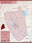
Farmington: Franklin County's Shiretown - Early Settlers
"Early Settlers Click the icon for a map of the locations of early settler's homesteads X By Nancy Porter, Researcher & Page Creator With…"
Site Page

"Contested Northeast boundary map, 1843Maine Historical Society The Maine land companies which had been organized in the wake of the fall of…"
Site Page

"This ill-defined boundary, based on an inaccurate map, was laid out in the Treaty of Paris in 1783. Maine Historical Society The European history of…"
Site Page
"“Red Lines on Maps: The Impact of Cartographical Errors on the Border between the United States and British North America, 1782-1842,” Imago Mundi…"
Site Page

Beyond Borders - Mapping Maine and the Northeast Boundary - Project Partners
"Project Partners The National Endowment for the Humanities (NEH) X In April 2020, Maine Historical Society received a $341,935 Humanities…"
Site Page

Beyond Borders - Mapping Maine and the Northeast Boundary - Borderland Essays
"Borderland Essays Explore essays, listed in the menu at right, pertaining to the drawing of the northeast boundary between the United States in…"
Site Page
"… economic activities, in short, undergirded both Wabanaki society and White New England colonists’ investment in and settlement of early Maine."
Site Page

"… White New Englanders invested in and settled in early Maine, they mobilized kinship ties that structured colonial business and investing practices."
