Keywords: US Coast Maps
- Historical Items (1)
- Tax Records (0)
- Architecture & Landscape (0)
- Online Exhibits (9)
- Site Pages (8)
- My Maine Stories (2)
- Lesson Plans (0)
Site Pages
These sites were created for each contributing partner or as part of collaborative community projects through Maine Memory. Learn about collaborative projects on MMN.
Site Page

"… dramatic conflict over land claims in the mid-coast region of Maine that have been expertly assessed for the Colonial and Revolutionary eras by…"
Site Page

"… northeast of Passamaquoddy Bay, from the Atlantic coast to the Gulf of St. Lawrence, and used Champlain’s Saint Croix River as a western boundary."
Site Page
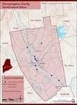
Farmington: Franklin County's Shiretown - Early Settlers
"… from Martha’s Vineyard – an island just off the coast of Cape Cod, Mass. Their roots went back several generations on the Vineyard, and in addition…"
Site Page

Cumberland & North Yarmouth - Our Shared History - Page 1 of 4
"… land into lots and built along the immediate coast, particularly near the Royal River, named for William Royall, one of the earliest settlers of…"
Site Page

Westport Island History Committee
View collections, facts, and contact information for this Contributing Partner.
Site Page

"… Cutter Service (later to become the United States Coast Guard), commissioning Hopley Yeaton as its first officer."
Site Page

Scarborough Historical Society & Museum
View collections, facts, and contact information for this Contributing Partner.
Site Page

Cumberland & North Yarmouth - "Main Streets" of North Yarmouth and Cumberland
"… Road Heading north and east from Boston along the coast of Maine, a shore road known as King's Highway was established in 1653."
