Keywords: Survey Map
- Historical Items (181)
- Tax Records (0)
- Architecture & Landscape (50)
- Online Exhibits (12)
- Site Pages (65)
- My Maine Stories (0)
- Lesson Plans (0)
Historical Items
These results include photographs, documents, letters, paintings, artifacts, and many other kinds of Maine related items from collections around the state and elsewhere.
Item 8563

British survey highlands map, ca. 1840
Contributed by: Maine Historical Society Date: circa 1840 Media: Ink on paper
Item 110895

Plan of the islands at the mouth of the River St. Clair, ca. 1823
Contributed by: Maine Historical Society Date: circa 1823 Media: Ink on paper
Item 5741

Detail from a Map of Portland Harbour and islands, 1825
Contributed by: Maine Historical Society Date: 1825 Location: Portland Media: Ink on paper, jpg
Item 110967

Map of Islands on Lake Huron, ca. 1820
Contributed by: Maine Historical Society Date: circa 1820 Location: Drummond Media: Ink on paper
Item 108759

Survey of land in Poland, 1842
Contributed by: Maine Historical Society Date: 1842 Location: Poland Media: Ink on paper
Item 110355

Survey of lots, Georgetown, 1793
Contributed by: Maine Historical Society Date: circa 1780 Location: Lubec Media: Ink on paper
Item 16541

Map of lakes of Franklin and Oxford counties, 1876
Contributed by: Maine Historical Society Date: 1876 Media: Ink on paper
Item 98903
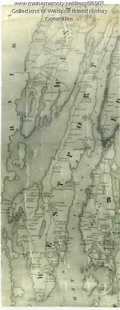
Contributed by: Westport Island History Committee Date: 1857 Location: Westport Island Media: Ink on paper, photograph
Item 116503

Manuscript map of Lake St. Clair, 1820
Contributed by: Maine Historical Society Date: 1820 Media: Ink on paper
Item 116488

A New Map of the Province of Lower Canada, 1838
Contributed by: Maine Historical Society Date: 1838 Media: Ink on paper
Item 11963
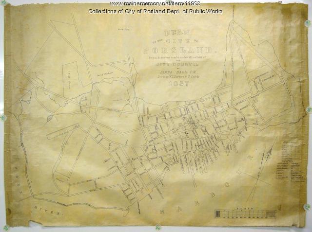
Plan of the City of Portland, 1837
Contributed by: City of Portland Dept. of Public Works Date: 1837 Location: Portland Media: Ink on paper, map
Item 6851

Chief Wasp map of Lake Vermillion, Sandy Point, ca. 1820
Contributed by: Maine Historical Society Date: circa 1825 Media: Graphite on paper
Item 148977

Map of Dead River Plantation, ca. 1915
Contributed by: Maine Historical Society Date: circa 1915 Location: Dead River Plantation Media: Ink on linen
Item 74772

Electric rural road survey, Boothbay, 1929
Contributed by: Maine Historical Society Date: 1929 Location: Boothbay; Edgecomb Media: Ink on paper
Item 12937
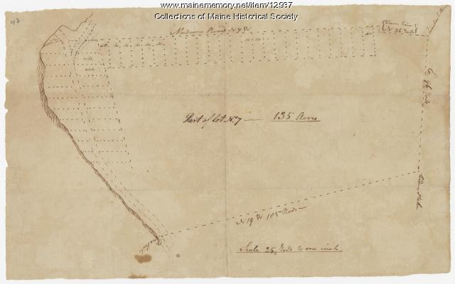
Map of lot no. 7, 135 acres on Madison Road, Skowhegan, ca. 1760
Contributed by: Maine Historical Society Date: circa 1760 Location: Skowhegan Media: Ink on paper
Item 9601

Cocumgomuc Mountains, Talcott Survey, 1841
Contributed by: Maine Historical Society Date: 1840 Media: Phototransparency
Item 116495

Manuscript map of Loon's Narrows & Lac Du Bois, ca. 1822
Contributed by: Maine Historical Society Date: circa 1822 Media: Ink on paper
Item 18728

Plan of Georgetown, Maine, 1839
Contributed by: Maine Historical Society Date: 1839 Location: Georgetown; Georgetown Media: Ink, pencil, watercolor, map
Item 33928

Survey plot, Cambridge Commons, 1792
Contributed by: Jonathan Fisher Memorial, Inc. Date: 1792 Location: Blue Hill Media: Ink on paper
Item 116516

Extract from a Map of the British and French Dominions in North America, 1755
Contributed by: Maine Historical Society Date: circa 1755 Media: Ink on paper
Item 108766

Plan of lot no. 1, Lewiston, ca. 1800
Contributed by: Maine Historical Society Date: circa 1800 Location: Lewiston Media: Ink on paper
Item 109022

Disputed lot E, Brunswick, 1811
Contributed by: Maine Historical Society Date: 1811-09-03 Location: Brunswick Media: Ink on paper
Item 18727

Plan of Georgetown, Maine, 1829
Contributed by: Maine Historical Society Date: 1829 Location: Georgetown Media: Ink, watercolor, map
Item 108764

Plan of suit, Little v. Field, 1823
Contributed by: Maine Historical Society Date: 1823 Media: Ink on paper
