Keywords: Survey Map
- Historical Items (181)
- Tax Records (0)
- Architecture & Landscape (50)
- Online Exhibits (12)
- Site Pages (65)
- My Maine Stories (0)
- Lesson Plans (0)
Historical Items
These results include photographs, documents, letters, paintings, artifacts, and many other kinds of Maine related items from collections around the state and elsewhere.
Item 28353
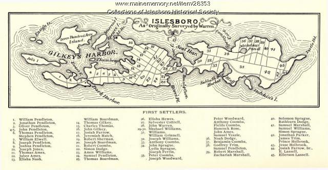
Warren Survey Map, Islesboro, ca. 1893
Contributed by: Islesboro Historical Society Date: circa 1799 Location: Islesboro Media: Ink on paper
Item 78950

Salem Towne Map, Mount Desert Island, ca. 1808
Contributed by: Mount Desert Island Historical Society Date: circa 1808 Location: Mount Desert Island Media: Map
Item 110888

Map of the Northern part of the state of Maine and of the adjacent British Provinces, 1830
Contributed by: Maine Historical Society Date: circa 1830 Media: Ink on paper
Item 108768

Survey of lot no. 90, Durham, ca. 1790
Contributed by: Maine Historical Society Date: circa 1790 Location: Durham Media: Ink on paper
Item 102070

Early map of Lewiston, Auburn and Minot, ca. 1820
Contributed by: Maine Historical Society Date: circa 1820 Location: Auburn; Lewiston; Minot Media: Ink on paper
Item 108862

Survey of lots for Peter Brown, Georgetown, 1761
Contributed by: Maine Historical Society Date: 1761-01-12 Location: Bath Media: Ink on paper
Item 102069

Early map of Lewiston, Auburn and Minot, 1820
Contributed by: Maine Historical Society Date: 1820 Location: Lewiston; Auburn; Minot Media: Ink on paper
Item 30213

Contributed by: Prince Memorial Library Date: 1857 Location: Cumberland Media: Wall map, ink on paper
Item 108835

Plan of lots 1-10, Fairfield, 1782
Contributed by: Maine Historical Society Date: 1782-12-20 Location: Fairfield Media: Ink on paper
Item 116533

St. John River boundary survey, 1843-1844
Contributed by: Maine Historical Society Date: circa 1844 Media: Ink on paper
Item 10834

Maine, Freeport sheet, Topographic map, 1892
Contributed by: Maine Historical Society Date: 1892 Media: Ink on paper
Item 105270

Manuscript map of Windham, 1872
Contributed by: Osher Map Library and Smith Center for Cartographic Education Date: circa 1740 Location: Windham Media: Ink on Paper
Item 105268

Contributed by: Osher Map Library and Smith Center for Cartographic Education Date: 1875 Location: Belfast Media: Lithograph
Item 110945

International water boundary between the United States and the Dominion of Canada, ca. 1893
Contributed by: Maine Historical Society Date: 1893 Media: Ink on paper
Item 10097

Contributed by: The General Henry Knox Museum Date: 1786 Media: Ink on paper
Item 10833

Topographic map, Bath sheet, 1894
Contributed by: Maine Historical Society Date: 1894 Media: Map, ink on paper
Item 116534

St. John River boundary survey, Five Islands, 1843
Contributed by: Maine Historical Society Date: 1843 Media: Ink on paper
Item 14760

Map of Portland Harbour and islands, 1825
Contributed by: Maine Historical Society Date: 1825 Media: Ink on paper, map
Item 31237

Moses Banks Map, Scarborough, 1787
Contributed by: Scarborough Historical Society & Museum Date: 1787 Location: Scarborough Media: Paper and ink
Item 16997

Map of Fryeburg Village in 1878
Contributed by: Fryeburg Historical Society Date: circa 1878 Location: Fryeburg Media: Map
Item 116515

St. John River boundary survey, from Rose Island north and east, 1844
Contributed by: Maine Historical Society Date: 1844 Media: Ink on paper
Item 116537

St. John River boundary survey no. 2, 1843
Contributed by: Maine Historical Society Date: 1843 Media: Ink on paper
Item 11826

Moses Greenleaf's map of the District of Maine, 1815
Contributed by: Maine Historical Society Date: 1815 Media: Ink on paper, map
Item 31520

Locating the old houses of Cumberland map, by Hope Dilloway, 1989
Contributed by: Prince Memorial Library Date: circa 1871 Location: Cumberland Media: Ink and watercolor on paper
