Keywords: Survey
- Historical Items (542)
- Tax Records (4)
- Architecture & Landscape (104)
- Online Exhibits (28)
- Site Pages (94)
- My Maine Stories (2)
- Lesson Plans (0)
Historical Items
These results include photographs, documents, letters, paintings, artifacts, and many other kinds of Maine related items from collections around the state and elsewhere.
Item 108768

Survey of lot no. 90, Durham, ca. 1790
Contributed by: Maine Historical Society Date: circa 1790 Location: Durham Media: Ink on paper
Item 98905

Trawl Survey for Maine Yankee, Westport Island, ca. 1978
Contributed by: Westport Island History Committee Date: circa 1978 Location: Westport Island Media: Photographic print
Item 116533

St. John River boundary survey, 1843-1844
Contributed by: Maine Historical Society Date: circa 1844 Media: Ink on paper
Item 13057

Portland Breakwater and Lighthouse, 1962
Contributed by: Maine Historical Society Date: 1962 Location: South Portland Media: Photographic print
Item 11259

Contributed by: Old York Historical Society Date: circa 1750 Location: York; York Media: Walnut, iron
Item 110945

International water boundary between the United States and the Dominion of Canada, ca. 1893
Contributed by: Maine Historical Society Date: 1893 Media: Ink on paper
Item 28353
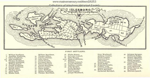
Warren Survey Map, Islesboro, ca. 1893
Contributed by: Islesboro Historical Society Date: circa 1799 Location: Islesboro Media: Ink on paper
Item 116534

St. John River boundary survey, Five Islands, 1843
Contributed by: Maine Historical Society Date: 1843 Media: Ink on paper
Item 116515

St. John River boundary survey, from Rose Island north and east, 1844
Contributed by: Maine Historical Society Date: 1844 Media: Ink on paper
Item 116537

St. John River boundary survey no. 2, 1843
Contributed by: Maine Historical Society Date: 1843 Media: Ink on paper
Item 135999

Barclay Collection Survey Reports, 1817-1826
Contributed by: Maine Historical Society Date: 1817–1826 Media: Ink on Paper
Item 9599

Mucalesa Mountain from Mucalesa Pond, Talcott Survey, 1841
Contributed by: Maine Historical Society Date: 1841 Media: Phototransparency
Item 108862

Survey of lots for Peter Brown, Georgetown, 1761
Contributed by: Maine Historical Society Date: 1761-01-12 Location: Bath Media: Ink on paper
Item 33926

Survey Instrument, Blue Hill, 1809
Contributed by: Farnsworth Museum of Art through Jonathan Fisher Memorial, Inc. Date: circa 1809 Location: Blue Hill Media: Wood, glass, metal
Item 9601

Cocumgomuc Mountains, Talcott Survey, 1841
Contributed by: Maine Historical Society Date: 1840 Media: Phototransparency
Item 33928

Survey plot, Cambridge Commons, 1792
Contributed by: Jonathan Fisher Memorial, Inc. Date: 1792 Location: Blue Hill Media: Ink on paper
Item 105350

Survey of two townships on the Kennebec River, 1790
Contributed by: Osher Map Library and Smith Center for Cartographic Education Date: 1790 Location: Madison; Cornville Media: Ink on Paper
Item 10522

Kennebec and Sheepscot rivers, 1868
Contributed by: Maine Historical Society Date: 1868 Media: Ink on paper
Item 108765

Edward Little plan of lots, ca. 1820
Contributed by: Maine Historical Society Date: circa 1820 Media: Ink on paper
Item 9597

View from Station 212, Talcott survey, 1841
Contributed by: Maine Historical Society Date: 1841 Media: Phototransparency
Item 74772

Electric rural road survey, Boothbay, 1929
Contributed by: Maine Historical Society Date: 1929 Location: Boothbay; Edgecomb Media: Ink on paper
Item 12178

Moses Greenleaf vertical sections, 1829
Contributed by: Maine Historical Society Date: 1829 Media: Ink on paper
Item 108767

Plan of land in Brunswick, ca. 1800
Contributed by: Maine Historical Society Date: circa 1800 Location: Brunswick Media: Ink on paper
Item 108753

Plan of the Bracket Lots, Androscoggin County, ca. 1800
Contributed by: Maine Historical Society Date: circa 1800 Location: Durham Media: Ink on paper
