Keywords: Old maps
- Historical Items (18)
- Tax Records (0)
- Architecture & Landscape (4)
- Online Exhibits (23)
- Site Pages (55)
- My Maine Stories (6)
- Lesson Plans (0)
Site Pages
These sites were created for each contributing partner or as part of collaborative community projects through Maine Memory. Learn about collaborative projects on MMN.
Site Page

Farmington: Franklin County's Shiretown - Maps
"All the other maps were built on the base map. Farmington Base Map Farmington Agricultural Sites Farmington Cemeteries Farmington Cultural Interest…"
Site Page

Beyond Borders - Mapping Maine and the Northeast Boundary - Further Reading
"Edelson, S. Max. The New Map of Empire: How Britain Imagined America before Independence. Cambridge, MA: Harvard University Press, 2017."
Site Page
Beyond Borders - Mapping Maine and the Northeast Boundary - Kennebec Proprietors Biographies
"He is listed on the John North map as surveyor. His fervent efforts kickstarted the company's incorporation and early activity around 1750."
Site Page
"… his property until he was past eighty years old. Josiah was also involved in shipping in Newburyport with his cousin Jacob Little."
Site Page
"This manner of claim did not rely on century-old parchment proof, and it could not be adjudicated by courts stacked with the proprietors’ cronies."
Site Page

"… decrying, much like the “liberty men” of old, any possible settlement related to the illegal taking of Wabanaki lands by the states of…"
Site Page

Farmington: Franklin County's Shiretown - The Brick Inn
"… has been noted on this 1861 Walling Topographical Map of the Franklin County with Town of Farmington noted (map from Library of Congress)."
Site Page
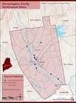
Farmington: Franklin County's Shiretown - Early Settlers
"Early Settlers Click the icon for a map of the locations of early settler's homesteads X By Nancy Porter, Researcher & Page Creator With…"
Site Page

Farmington: Franklin County's Shiretown - Education
"Education Click the icon to see a map of the early schools of Farmington. X By Nancy Porter, Researcher and Page Creator With images from…"
Site Page
Farmington: Franklin County's Shiretown - Franklin County Agricultural Fair
"… and $5 for “best bull, not less than 2 years old.” By 1901, at the 62nd Annual Exhibition of the Franklin County Agricultural Society, held on the…"
Site Page

Farmington: Franklin County's Shiretown - Elizabeth Akers Allen, née Chase
"… published when she was between 12 and 15 years old, under the pen name "Florence Percy". In 1855, using her pen name, she published her first book…"
Site Page
Farmington: Franklin County's Shiretown - Chester Greenwood
"… did indeed patent Ear Muffs when he was 15 years old. And before too many years passed, Chester was producing earmuffs in a factory in West…"
Site Page

"When the baby was just five weeks old, Stephen and Betsey Titcomb set out for their new home. They would have to travel 70 miles into the wilderness…"
Site Page

Farmington: Franklin County's Shiretown - The Abbott School
"… of a new dormitory on Main and Depot Streets, the old Fraternity building would no longer be needed (1962) and was demolished by a local contractor."
Site Page
Farmington: Franklin County's Shiretown - Railroad into the Village
"… it must cross on piles – some 800 feet, and the old Iron Horse, with his freight of timber and piles, goes over it a distance of about 600 feet."
Site Page

Bath's Historic Downtown - History Overview
"… SEE NOTE Detail of USGS Topographical Map of Bath, 2000Patten Free Library Introduction Downtown Bath, the heart of the City of Ships…"
Site Page

Bath's Historic Downtown - Project Resources
"… 1894, “History of Bath and Environs, 1607-1894.” Maps Map of Part of the Town of Bath, A. Hammett, circa 1830. City of Bath, Lincoln County, Maine."
Site Page

Bath's Historic Downtown - The Customs House
"1901Patten Free Library According to the 1851 map of Bath, three separate buildings occupied the property where the Customs House was later built."
Site Page

Bath's Historic Downtown - Project Overview
"Students attempted to fill in blank maps of the city, list as many facts as they could recall, and pose thoughtful questions on topics that they were…"
Site Page

Bath's Historic Downtown - Intersection of Centre and Washington
"According to several city maps, around 1910, the church had a vestry added to it. In 1890, a large organ was purchased for the church."
Site Page
Bath's Historic Downtown - 94 Front Street
"… in the early 1850s, according to the 1858 map of Bath, and city tax records, David Tilden Stinson rented the location from Oliver Moses, running a…"
Site Page

View collections, facts, and contact information for this Contributing Partner.
Site Page

Strong, a Mussul Unsquit village - About Us - Page 3 of 3
"… the society’s start of the yearlong Maine Memory project to research and map local homes, businesses and townspeople’s lives after the Civil War."
Site Page

View collections, facts, and contact information for this Contributing Partner.
