Keywords: Maine Map
- Historical Items (926)
- Tax Records (0)
- Architecture & Landscape (209)
- Online Exhibits (33)
- Site Pages (232)
- My Maine Stories (8)
- Lesson Plans (5)
Historical Items
These results include photographs, documents, letters, paintings, artifacts, and many other kinds of Maine related items from collections around the state and elsewhere.
Item 12100

Contributed by: Aroostook County Historical and Art Museum Date: 1887 Location: Houlton Media: Ink on paper
Item 28353
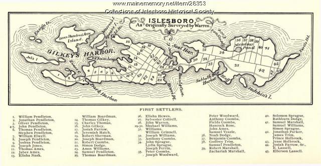
Warren Survey Map, Islesboro, ca. 1893
Contributed by: Islesboro Historical Society Date: circa 1799 Location: Islesboro Media: Ink on paper
Item 110888

Map of the Northern part of the state of Maine and of the adjacent British Provinces, 1830
Contributed by: Maine Historical Society Date: circa 1830 Media: Ink on paper
Item 104602

A plan of the District of Maine, 1795
Contributed by: Osher Map Library and Smith Center for Cartographic Education Date: 1795 Media: Ink on Paper
Item 104782

Contributed by: Osher Map Library and Smith Center for Cartographic Education Date: 1793 Media: Engraving
Item 104604

New Map of English America, 1677
Contributed by: Osher Map Library and Smith Center for Cartographic Education Date: 1777 Media: Engraving
Item 105269

Map of Maine drawn by Sarah N. Young, 1822
Contributed by: Osher Map Library and Smith Center for Cartographic Education Date: 1822 Media: Ink on Paper
Item 11826

Moses Greenleaf's map of the District of Maine, 1815
Contributed by: Maine Historical Society Date: 1815 Media: Ink on paper, map
Item 105630

Contributed by: Maine Historical Society Date: 1835 Media: Ink on paper
Item 30213

Contributed by: Prince Memorial Library Date: 1857 Location: Cumberland Media: Wall map, ink on paper
Item 11784

Map of the Inhabited Part of Maine, Moses Greenleaf, 1829
Contributed by: Maine Historical Society Date: 1778 Media: Ink on paper, map
Item 11285

Map of the Conquest of Katahdin, 1933
Contributed by: Baxter State Park Date: 1934 Location: Mt. Katahdin Twp. Media: Ink on paper, Photographic print
Item 104601

Contributed by: Osher Map Library and Smith Center for Cartographic Education Date: 1677 Media: Woodcut
Item 4177

Contributed by: Maine Historical Society Date: circa 1801 Media: Paper
Item 12098

Contributed by: Aroostook County Historical and Art Museum Date: 1894 Location: Houlton Media: Ink on paper
Item 102069

Early map of Lewiston, Auburn and Minot, 1820
Contributed by: Maine Historical Society Date: 1820 Location: Lewiston; Auburn; Minot Media: Ink on paper
Item 111027

Manuscript map of the Lake of the Woods, ca. 1820
Contributed by: Maine Historical Society Date: circa 1820 Media: Ink on paper
Item 17574

Railroad map of Northern Maine, 1910
Contributed by: Maine Historical Society Date: 1910 Media: Ink on paper, map
Item 9166

Contributed by: Maine Historical Society Date: 1795 Media: Ink on paper
Item 23342

Contributed by: Maine Historical Society Date: circa 1850 Location: Thomaston Media: Ink on paper, map
Item 96522

Baldwin and Sebago lot map, ca. 1820
Contributed by: Baldwin Historical Society Date: circa 1805 Location: Baldwin; Sebago Media: ink on paper
Item 11854

Moses Greenleaf's Map of the inhabited part of the state of Maine, 1829
Contributed by: Maine Historical Society Date: 1778 Media: Ink wash on lithograph, Map
Item 35628

Map of 1866 Portland Fire, 1866
Contributed by: Maine Historical Society Date: 1866-07-04 Location: Portland Media: Ink on paper
Item 105267

Contributed by: Osher Map Library and Smith Center for Cartographic Education Date: 1874 Location: Skowhegan Media: Lithograph
