Keywords: Landowners.
- Historical Items (423)
- Tax Records (19146)
- Architecture & Landscape (4)
- Online Exhibits (17)
- Site Pages (57)
- My Maine Stories (2)
- Lesson Plans (0)
Historical Items
These results include photographs, documents, letters, paintings, artifacts, and many other kinds of Maine related items from collections around the state and elsewhere.
Item 68913

Scarborough landowners, ca. 1800
Contributed by: Maine Historical Society Date: circa 1800 Location: Scarborough Media: Ink on paper
Item 102767

Copy of a plan of lands on the west side of Madomack River, Waldoboro, 1774
Contributed by: Maine Historical Society Date: 1774 Location: Waldoboro Media: Ink on paper
Item 108959

Plat of a tract of land in Woolwich, 1751
Contributed by: Patten Free Library Date: 1751-11-29 Location: Woolwich Media: Watercolor on paper
Item 34148

Black Point, Scarborough, ca. 1741
Contributed by: Scarborough Historical Society & Museum Date: circa 1741 Location: Scarborough Media: Paper on cardboard
Item 7582

Kennebec Proprietor meeting notes, Boston, 1751
Contributed by: Maine Historical Society Date: 1751-12-06 Location: Boston Media: Ink on paper
Item 5320

Peletiah Haly's lot, Haly's Island, ca. 1750
Contributed by: Maine Historical Society Date: circa 1750 Location: Topsham; Brunswick Media: Ink on paper
Item 58323
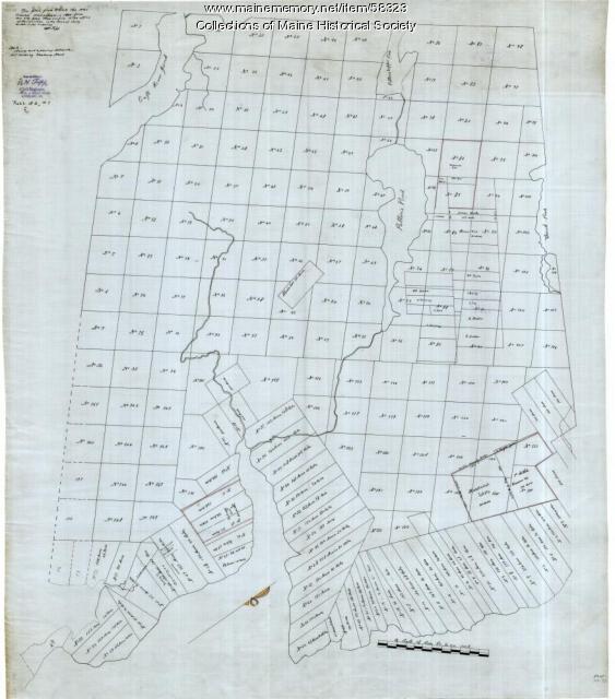
Copy of Surry and Ellsworth map, ca. 1880
Contributed by: Maine Historical Society Date: circa 1880 Location: Ellsworth; Surry Media: Ink on paper
Item 7311

Ferdinand Gorges' land deed to Thomas Cammock, 1634
Contributed by: Maine Historical Society Date: 1634-05-01 Media: Ink on paper
Item 12855

Plan of Cumberland and Lincoln counties, 1773
Contributed by: Maine Historical Society Date: 1773 Media: Ink on paper
Item 12851

Contributed by: Maine Historical Society Date: 1798 Media: Ink on paper
Item 12560

Plan of lots on Sheepscot Pond, Palermo, 1806
Contributed by: Maine Historical Society Date: 1806-06-27 Location: Palermo Media: Ink on paper
Item 68866

Libby River land, Scarborough, 1794
Contributed by: Maine Historical Society Date: 1794 Location: Scarborough; Scarborough Media: Ink on paper, map
Item 4316

Plan of J. Robinson lot, Topsham, 1761
Contributed by: Maine Historical Society Date: 1761 Location: Topsham Media: Ink on paper
Item 102071

Map of early Greene, Lewiston and Sabattus, ca. 1790
Contributed by: Maine Historical Society Date: circa 1790 Location: Sabattus; Greene Media: Ink on vellum
Item 20784

Black Point, Scarborough, ca. 1633 - 1728
Contributed by: Maine Historical Society Date: circa 1633 Location: Scarborough Media: Ink on paper, map
Item 68870

Lower part of Scarborough, ca. 1740
Contributed by: Maine Historical Society Date: circa 1740 Location: Scarborough Media: Ink and wash on paper
Item 35621
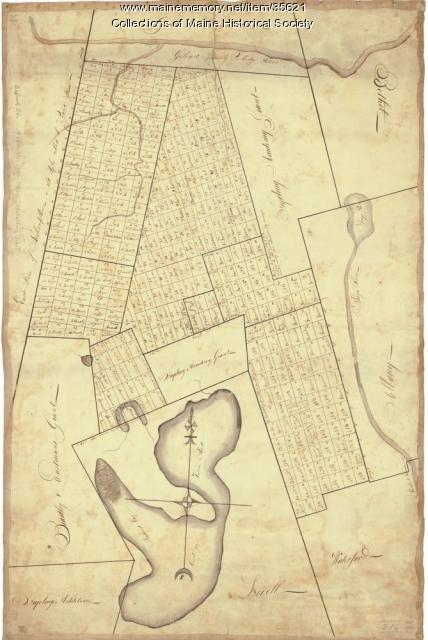
Contributed by: Maine Historical Society Date: circa 1792 Location: Stoneham; Lovell; Bethel; Albany; Mason Twp.; Bachelders Grant Media: Ink on fabric
Item 12852

Kennebec River above Fort Western, ca. 1800
Contributed by: Maine Historical Society Date: circa 1800 Media: Ink on paper
Item 12566

Contributed by: Maine Historical Society Date: 1778 Location: Alna Media: Ink on paper
Item 12125

Map of Cobbosseecontee Stream, 1765
Contributed by: Maine Historical Society Date: 1765-07-29 Location: Augusta; Gardiner; Farmingdale; Hallowell; Litchfield; Manchester; Winthrop; Monmouth Media: Ink on paper
Item 12943

Plan of lots on the Sheepscot River, Alna, 1798
Contributed by: Maine Historical Society Date: 1759 Location: Alna Media: Ink on paper
Item 5960

Fort land for William Ross, Brunswick, ca. 1763
Contributed by: Maine Historical Society Date: circa 1763 Location: Brunswick Media: Ink on paper
Item 11720

Contributed by: Maine Historical Society Date: 1740-09-29 Location: Brunswick Media: Ink on paper
Item 11725

Contributed by: Maine Historical Society Date: 1772 Location: Brunswick Media: Ink on paper
