Keywords: Historical Map
- Historical Items (579)
- Tax Records (0)
- Architecture & Landscape (208)
- Online Exhibits (31)
- Site Pages (171)
- My Maine Stories (2)
- Lesson Plans (5)
Historical Items
These results include photographs, documents, letters, paintings, artifacts, and many other kinds of Maine related items from collections around the state and elsewhere.
Item 105436

Contributed by: Osher Map Library and Smith Center for Cartographic Education Date: 1856 Location: Gardiner Media: Lithograph
Item 11777

Contributed by: Maine Historical Society Date: circa 1905 Media: Ink on paper, map
Item 105440

Map of Portland with illustrations of buildings, 1836
Contributed by: Osher Map Library and Smith Center for Cartographic Education Date: 1836 Location: Portland Media: Engraving
Item 10684
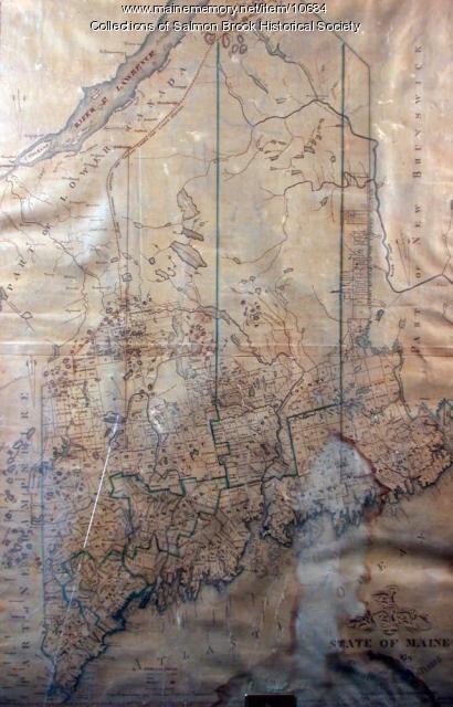
Contributed by: Salmon Brook Historical Society Date: circa 1825 Media: Digital photograph of printed map
Item 105442

Maine coast, a map of Casco Bay, 1960
Contributed by: Osher Map Library and Smith Center for Cartographic Education Date: 1632–1960 Location: Portland; Brunswick; Phippsburg Media: Lithograph
Item 78950

Salem Towne Map, Mount Desert Island, ca. 1808
Contributed by: Mount Desert Island Historical Society Date: circa 1808 Location: Mount Desert Island Media: Map
Item 105353

"Geographical, statistical, and historical map of Maine," 1826
Contributed by: Osher Map Library and Smith Center for Cartographic Education Date: 1826 Media: Engraving
Item 105920

Redline map of Portland and South Portland, 1935
Contributed by: Maine Historical Society Date: 1935-11-15 Location: Portland; South Portland Media: Ink on paper
Item 12100

Contributed by: Aroostook County Historical and Art Museum Date: 1887 Location: Houlton Media: Ink on paper
Item 28353
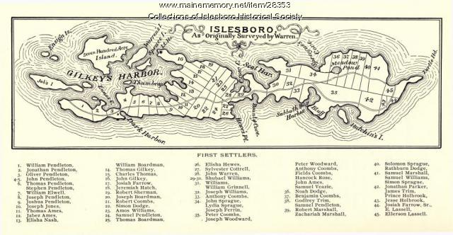
Warren Survey Map, Islesboro, ca. 1893
Contributed by: Islesboro Historical Society Date: circa 1799 Location: Islesboro Media: Ink on paper
Item 110888

Map of the Northern part of the state of Maine and of the adjacent British Provinces, 1830
Contributed by: Maine Historical Society Date: circa 1830 Media: Ink on paper
Item 104601

Contributed by: Osher Map Library and Smith Center for Cartographic Education Date: 1677 Media: Woodcut
Item 111027

Manuscript map of the Lake of the Woods, ca. 1820
Contributed by: Maine Historical Society Date: circa 1820 Media: Ink on paper
Item 12098

Contributed by: Aroostook County Historical and Art Museum Date: 1894 Location: Houlton Media: Ink on paper
Item 102069

Early map of Lewiston, Auburn and Minot, 1820
Contributed by: Maine Historical Society Date: 1820 Location: Lewiston; Auburn; Minot Media: Ink on paper
Item 23342

Contributed by: Maine Historical Society Date: circa 1850 Location: Thomaston Media: Ink on paper, map
Item 96522

Baldwin and Sebago lot map, ca. 1820
Contributed by: Baldwin Historical Society Date: circa 1805 Location: Baldwin; Sebago Media: ink on paper
Item 35628

Map of 1866 Portland Fire, 1866
Contributed by: Maine Historical Society Date: 1866-07-04 Location: Portland Media: Ink on paper
Item 105267

Contributed by: Osher Map Library and Smith Center for Cartographic Education Date: 1874 Location: Skowhegan Media: Lithograph
Item 102070

Early map of Lewiston, Auburn and Minot, ca. 1820
Contributed by: Maine Historical Society Date: circa 1820 Location: Auburn; Lewiston; Minot Media: Ink on paper
Item 10833

Topographic map, Bath sheet, 1894
Contributed by: Maine Historical Society Date: 1894 Media: Map, ink on paper
Item 100727

Contributed by: Maine Historical Society Date: 1826 Location: Portland Media: Watercolor and pen and ink, mounted on fabric
Item 11833

Index Map of International Boundary, 1930
Contributed by: Maine Historical Society Date: 1930 Media: Ink on paper, map
Item 11834

Map showing Monument and Glendenning Brooks, 1924
Contributed by: Maine Historical Society Date: 1924 Media: Ink on paper, map
