Keywords: Georges River
- Historical Items (245)
- Tax Records (0)
- Architecture & Landscape (0)
- Online Exhibits (59)
- Site Pages (130)
- My Maine Stories (4)
- Lesson Plans (0)
Site Pages
These sites were created for each contributing partner or as part of collaborative community projects through Maine Memory. Learn about collaborative projects on MMN.
Site Page

Lincoln, Maine - About Our Project
"… Historical Society members: Jeannette King, George King, Bonnie Gray Contact the Lincoln Historical Society's president, Bonnie Gray, here."
Site Page

Beyond Borders - Mapping Maine and the Northeast Boundary - People
"Map by Francis Joseph Neptune, Cobscook River, 1798 Map by cartographer Chief Francis Joseph Neptune (Passamaquoddy), 1798Maine Historical Society…"
Site Page

"George King Interview on Railroads The train was used to transport passengers, as well. The passenger rail first went from Old Town to Lincoln, and…"
Site Page
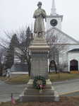
Lincoln, Maine - Jacob Stinchfield
"They had four children together named Ira, George, Charles, and Mary. His son, Charles, was the person who built the Civil War monument at the…"
Site Page

Lincoln, Maine - Telegraphs & Telephones
"Print. Ser. 3. King, George R. “Lincoln Light Power CO.” Lincoln Historical Society (1993): 252-54. Print. Whig and Courier. 1887th ser."
Site Page

"… by Robin Hood, in 1675, on the Wescustogo (Royal) River, and appeared on a deed regarding land on Merriconeag Neck with Robin Hood and her brother…"
Site Page

"Namely, the Androscoggin River where the Pejepscot Proprietors sold parcels for major settlements, and the Kennebec River watershed where the…"
Site Page

"Croix River. In the Passamaquoddy language the river was known as the Skutik River. Several testimonies were given about the location of the true St."
Site Page

Western Maine Foothills Region - Mexico - Page 2 of 3
"Passengers then would ford the river to Peru. When the river was low, foot passengers could walk across from the island to Peru on a natural causeway."
Site Page

"… the locative placename of the lower Androscoggin River, as Pejepscook (Pejepscot), and the upper river homeland, Ammoscongon (Amikôkan)."
Site Page

Western Maine Foothills Region - Rumford - Page 4 of 4
"… State of Maine with Numerous Illustrations, by George Jones Varney, 1836-1901, B. B. Russell, 57 Cornhill, Boston, MA., 1881; History of Rumford…"
Site Page

"… Proprietors? Plan of the Kennebec River describing the Plymouth patent, ca. 1719Maine Historical Society The Kennebec Proprietors traced…"
Site Page

"… efforts to have land grants east of the Penobscot River confirmed by the Crown, as the charter required, were stymied."
Site Page

"Croix River (as well as its source), and deciding how to follow the long St. John (Wolostoq) River and its tributaries, which was made especially…"
Site Page

"… and Local Reality, 1763-1842 Moose River, Moose Head Lake and Kennebeck Road, 1820Maine Historical Society Historian Francis M."
Site Page

"… reflection of the cross-shaped conjunction of the rivers around it or as a reflection on the party’s hopes of using the site as a base for…"
Site Page

"The fundamental issue was that, in the years since Champlain’s voyage, the precise location of the river had been lost."
Site Page

Western Maine Foothills Region - Ridlonville
"… contributed by Mexico Historical Society When George Ridlon arrived in 1894 and realized the economic possibilities of the Oxford Paper Company…"
Site Page
"Map by Francis Joseph Neptune, Cobscook River, 1798Maine Historical Society The Beyond Borders portal makes accessible three of the Maine Historical…"
Site Page

"For example, in a 1659 Kennebec River deed, Nanudemance retained “liberty unto me and my heirs to fish, fowl, and hunt also to set otter traps…"
Site Page

"… from the northwesternmost head of the Connecticut River, through the Great Lakes, and the eastern border’s terminus at Lake of the Woods (the…"
Site Page

"… of land made in the area east of the Kennebec River would be legally recognized unless separately and specifically approved by the British crown."
Site Page

"… veteran, and his attempts at protecting the Sandy River; and Polin, in his attempts at protecting the Presumpscot River, both through diplomacy and…"
Site Page

"… named Paul Chadwick in 1809 along the Kennebec River sapped popular support for continued resistance, convincing most residents to finally settle…"
