Category: Nature & Geography, Maps, Land grants
- Historical Items (162)
- Tax Records (0)
- Architecture & Landscape (0)
- Online Exhibits (3)
- Site Pages (0)
- My Maine Stories (0)
- Lesson Plans (0)
Historical Items
These results include photographs, documents, letters, paintings, artifacts, and many other kinds of Maine related items from collections around the state and elsewhere.
Item 102071

Map of early Greene, Lewiston and Sabattus, ca. 1790
Contributed by: Maine Historical Society Date: circa 1790 Location: Sabattus; Greene Media: Ink on vellum
Item 108848

Map and petition, Sandy River, 1798
Contributed by: Maine Historical Society Date: 1798 Location: New Vineyard; Farmington Media: Ink on paper
Item 12398

Early map of the Sheepscot River, 1816
Contributed by: Maine Historical Society Date: 1816-01-08 Location: Somerville; Whitefield; Windsor Media: Ink on paper
Item 12939

Henry May, James Larking lot, near the Sheepscot River, 1805
Contributed by: Maine Historical Society Date: 1805-11-25 Media: Ink on paper
Item 108750

Contributed by: Maine Historical Society Date: 1834-10-02 Location: Leeds Media: Ink on paper
Item 108751

50 acres bargained, Leeds, 1834
Contributed by: Maine Historical Society Date: 1834-10-02 Location: Leeds Media: Ink on paper
Item 108752

Plan of William Libby's lot, Durham, 1819
Contributed by: Maine Historical Society Date: 1819-12-08 Location: Durham Media: Ink on paper
Item 108753

Plan of the Bracket Lots, Androscoggin County, ca. 1800
Contributed by: Maine Historical Society Date: circa 1800 Location: Durham Media: Ink on paper
Item 108754

Plan excepting a road to Durham, 1821
Contributed by: Maine Historical Society Date: 1821-06-29 Location: Durham Media: Ink on paper
Item 108756

Plot adjacent to Peables' fence, ca. 1800
Contributed by: Maine Historical Society Date: circa 1800 Media: Ink on paper
Item 108759

Survey of land in Poland, 1842
Contributed by: Maine Historical Society Date: 1842 Location: Poland Media: Ink on paper
Item 108765

Edward Little plan of lots, ca. 1820
Contributed by: Maine Historical Society Date: circa 1820 Media: Ink on paper
Item 108766

Plan of lot no. 1, Lewiston, ca. 1800
Contributed by: Maine Historical Society Date: circa 1800 Location: Lewiston Media: Ink on paper
Item 108768

Survey of lot no. 90, Durham, ca. 1790
Contributed by: Maine Historical Society Date: circa 1790 Location: Durham Media: Ink on paper
Item 109022

Disputed lot E, Brunswick, 1811
Contributed by: Maine Historical Society Date: 1811-09-03 Location: Brunswick Media: Ink on paper
Item 5330

The Pejepscot Claim, September 15, 1764
Contributed by: Maine Historical Society Date: 1764-09-15 Location: Brunswick; Topsham; Freeport; Harpswell; Lewiston; North Yarmouth Media: Ink on paper
Item 6894

Plan of the Kennebec Million Acres, 1823
Contributed by: Maine Historical Society Date: 1823-10-17 Location: Kingfield; Moscow Media: Ink on paper
Item 7533

Map of Cape Elizabeth, Richmond Island area, 1884
Contributed by: Maine Historical Society Date: circa 1630 Location: Cape Elizabeth; Richmond Island Media: Ink on paper
Item 10097

Contributed by: The General Henry Knox Museum Date: 1786 Media: Ink on paper
Item 11775

Trelawny Black Point Deed, 1631
Contributed by: Maine Historical Society Date: 1631 Location: Scarborough; Scarborough Media: Ink on vellum
Item 12196

Map of Kennebec Purchase lots, ca. 1750
Contributed by: Maine Historical Society Date: circa 1750 Media: Ink on paper
Item 12197
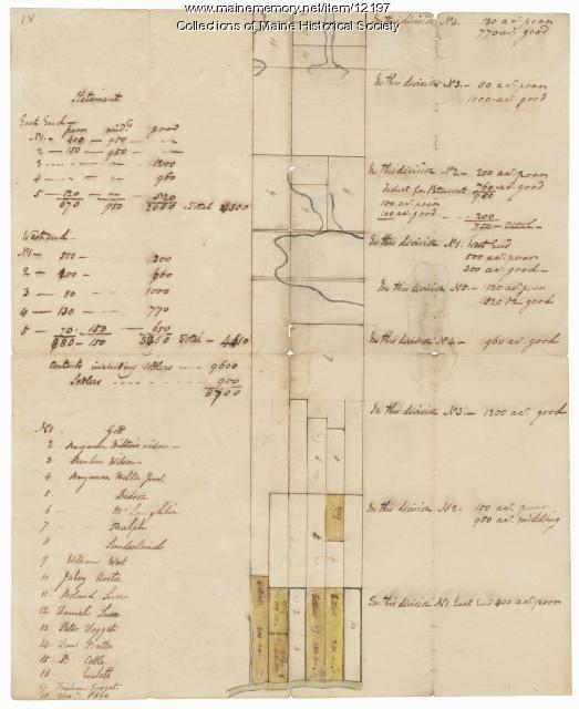
Division of the Tyng and Lowell estates, ca. 1760
Contributed by: Maine Historical Society Date: circa 1760 Media: Ink on paper
Item 12558

Contributed by: Maine Historical Society Date: circa 1800 Location: Skowhegan Media: Ink on paper
Item 12560

Plan of lots on Sheepscot Pond, Palermo, 1806
Contributed by: Maine Historical Society Date: 1806-06-27 Location: Palermo Media: Ink on paper
