Keywords: Wall Map
Item 105436

Contributed by: Osher Map Library and Smith Center for Cartographic Education Date: 1856 Location: Gardiner Media: Lithograph
Item 105318

Map of the town of Camden, 1875
Contributed by: Osher Map Library and Smith Center for Cartographic Education Date: 1875 Location: Camden; Rockland Media: Lithograph

Item 110501

Skylands, Mount Desert, 1922-2000
Contributed by: Maine Historical Society Date: 1922–2000 Location: Mount Desert Client: Martha Stewart Architect: Landscape Design Associates
Item 110446

Peters residence, Mount Desert, 1992-2008
Contributed by: Maine Historical Society Date: 1992–2008 Location: Mount Desert Client: Alton Peters Architect: Landscape Design Associates

Exhibit

The boundaries of Maine are the product of international conflict, economic competition, political fights, and contested development. The boundaries are expressions of human values; people determined the shape of Maine.
Exhibit

Home: The Longfellow House & the Emergence of Portland
The Wadsworth-Longfellow house is the oldest building on the Portland peninsula, the first historic site in Maine, a National Historic Landmark, home to three generations of Wadsworth and Longfellow family members -- including the boyhood home of the poet Henry Wadsworth Longfellow. The history of the house and its inhabitants provide a unique view of the growth and changes of Portland -- as well as of the immediate surroundings of the home.

Site Page

Farmington: Franklin County's Shiretown - The Brick Inn
"… of the Brick Inn has been noted on this 1861 Walling Topographical Map of the Franklin County with Town of Farmington noted (map from Library of…"
Site Page
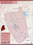
Farmington: Franklin County's Shiretown - Early Settlers
"The Ben Butlers tell us these murals were painted by Jonathan Poor, nephew of Rufus Porter. Other Farmington Falls homes boast walls with similar…"

Story

Vietnam Memoirs
by David Chessey
MY PERSONAL EXPERIENCES AND MY OBSERVATION OF NATIONWIDE OPINIONS CONCERNING THE “VIET NAM" WAR
