Keywords: Eastern Lands
Item 101444

Eastern lands broadside, ca. 1820
Contributed by: Maine Historical Society Date: circa 1820 Media: Ink on paper
Item 108702

"Southport" steamship at Five Islands, Georgetown, ca. 1915
Contributed by: Penobscot Marine Museum Date: circa 1915 Location: Georgetown Media: Glass Plate Negative

Exhibit

Lincoln County through the Eastern Eye
The Penobscot Marine Museum’s photography collections include nearly 50,000 glass plate negatives of images for "real photo" postcards produced by the Eastern Illustrating and Publishing Company of Belfast. This exhibit features postcards from Lincoln County.
Exhibit

Sagadahoc County through the Eastern Eye
The Eastern Illustrating and Publishing Company of Belfast, Maine. employed photographers who traveled by company vehicle through New England each summer, taking pictures of towns and cities, vacation spots and tourist attractions, working waterfronts and local industries, and other subjects postcard recipients might enjoy. The cards were printed by the millions in Belfast into the 1940s.

Site Page

"… father had once been the largest landowner in eastern Maine. Ashburton’s assessment of the 1842 treaty included that the final border was a “good…"
Site Page

"… documents from 1764 pertain to areas at the eastern end of the border (a survey of Passamaquoddy Bay by John Mitchell) and in the west (treaties…"

Story

The Point
by Norma K. Salway
In the summer, on the eastern shore of Songo, kids dove from a leaning tree
Story
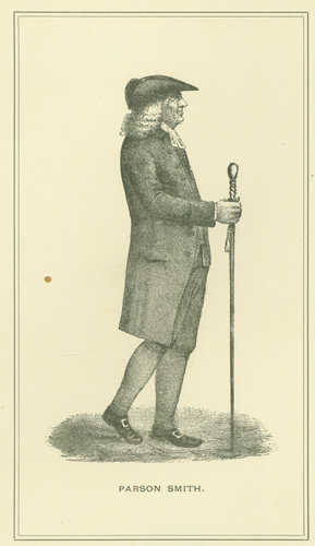
Reverend Thomas Smith of First Parish Portland
by Kristina Minister, Ph.D.
Pastor, Physician, Real Estate Speculator, and Agent for Wabanaki Genocide
